
Fact Sheet 13-02
Online Version 1.0
Federally Owned Coal and Federal Lands in the Northern and Central Appalachian Basin Coal Regions
By Susan J. Tewalt
|
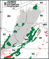
The U.S. Geological Survey (USGS) assessed five coal beds or coal zones in the northern and central
Appalachian Basin coal regions for the National Coal Resource Assessment: the Pittsburgh coal bed, the Upper Freeport coal bed, the Fire Clay coal zone, the Pond Creek coal zone, and the Pocahontas
No. 3 coal bed. The assessment produced stratigraphic and geochemical databases and digital coal maps, or models, which characterized the coal beds and coal zones. Using the assessment models, the USGS estimated original and remaining (unmined) resources for these coal beds or zones.
The Appalachian Basin assessment was conducted in collaboration with the State geological surveys of West Virginia, Pennsylvania, Ohio, Maryland, Kentucky, and Virginia. |
View a
Download Adobe
Acrobat Reader version 5.0 for free
URL: https://pubsdata.usgs.gov/pubs/fs/fs013-02/index.html
For more information, contact Susan J. Tewalt
Maintained by Eastern Publications Group
Last modified: 17:47:20 Tue 29 Nov 2016
Privacy statement | General disclaimer | Accessibility