![]()
 |
Robowell - Providing Accurate and Current Water-Level and Water-Quality Data in Real Time for Protecting Ground-Water ResourcesFact Sheet FS-053-02By Gregory E. Granato and Kirk P. Smith |
Accurate and current hydrologic data are necessary to protect the Nation's water-supply infrastructure because ground water is a limited and vulnerable resource. Robowell, an automated ground-water monitoring system, provides real-time data without incurring the high labor and laboratory costs associated with manual sampling. Using proven sampling methods, the Robowell system can monitor ground-water quality and water level in one or more wells at a monitoring site. This technology, if used with periodic manual sampling and appropriate calibration, provides the information necessary to detect abrupt changes, short-term variability, and seasonal and long-term trends in water quality and water levels. When Robowell detects these changes, it can quickly alert an operator. These capabilities make Robowell a steadfast sentry that can detect and report changes in water-quality or flow direction at contaminated sites, near potential sources of contaminants, or at public water-supply well fields.
Productive water-supply aquifers commonly occur in areas with shallow depths to ground water, permeable soils, and substantial flow rates, which render these aquifers susceptible to contamination from many sources (Trench, 1991; Harris and Steeves, 1994; Lent and others, 1997; Desimone and Ostiguy, 1999; Barlow, 2000). For instance, chemical spills and potential contamination commonly associated with various land-use practices (fig.1) can quickly degrade the water quality of a water-supply well. The design and operation of the supply well may also induce salt-water intrusion or surface-water infiltration, which would affect water quality. For example, Izbicki (2000) reported that a public-supply well in the Blackstone River Valley, Massachusetts draws water from the river to the well in as little as two days. The infiltrating river water adversely affects ground-water quality in this area. Recently, water suppliers, emergency planners, and the Department of Defense have recognized the potential for intentional chemical spills to sabotage drinking-water supplies (Lisa Olsen, U.S. Geological Survey, written commun., 2001).
|
|
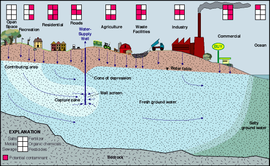
| Figure 1. Potential contaminants commonly associated with various land-use practices that may affect ground-water quality in aquifers used for water supply. |
Protecting public water supplies is crucial for protecting public health and investments in water-supply infrastructure (Trench, 1991; Harris and Steeves, 1994; Lent and others, 1997; Desimone and Ostiguy, 1999). Continuing development increases, the need to protect public water supplies. Development affects ground-water availability in two ways-it commonly increases water use and as development increases, it limits the number of pristine sites available for water-supply development. The balance between the availability of high-quality water and water demands is reaching a critical stage in many areas. For example, Harris and Steeves (1994) determined that only about 6 percent of the total area of Cape Cod was available for potential public-water-supply development after areas of ground-water contamination, potential saltwater-intrusion zones, and vulnerable land-use areas were eliminated. This fact is particularly notable because six sand and gravel aquifers underlie Cape Cod; therefore, the hydrologic setting does not limit potential locations of public water-supply-development areas, as is the case in many areas.
If the aquifer contributing water to a public-supply well is contaminated, little can be done to recover the resource. Active remediation is expensive and can take years to decades. Passive or natural remediation can take centuries before water in the area becomes fit to drink. Losing a well to contamination can be expensive because the value of the source area and the associated water-supply infrastructure is commonly lost. In addition, establishing and developing new water-supplies can be difficult and expensive.
Municipalities periodically sample water from supply wells to evaluate water quality. Contaminants may move into a water supply in the time between manual sampling events. By the time contaminants are usually detected, much of the area contributing water to a well may be contaminated. If early detection of contaminants is possible, pumping rates may be reduced, which will decrease the capture zone of the well, and a portion of the aquifer's production capacity may be retained.
Real-time water-level and water-quality monitoring data may help define the magnitude and variability of contamination from different land uses and may provide information for better management of water-supply areas. For instance, real-time monitoring near potential sources of pollution in and around the capture zone of public-supply wells may provide the information needed to detect contamination before it affects the supply area. Real-time water-quality monitoring also may be used to optimize the operation of existing well fields by minimizing the infiltration of surface water or saltwater, which may substantially impair the quality of public supply. Conversely, ground-water monitoring also may be used to identify subsurface discharge of ground-water contaminants to surface-water resources. Research and experience show that passive monitoring (by suspending a water-quality probe in a well) commonly does not provide representative measurements of water quality in the aquifer surrounding a monitoring well, and pumping well water is necessary to ensure representative measurements (Smith and Granato, 1998; Granato and Smith, 2001; Craig Wiegand, Water Superintendent, Provincetown Water Department, written commun., 2001).
To help monitor valuable ground-water resources, the U.S. Geological Survey developed, tested, and patented Robowell. This system measures and records values of selected water-quality properties and constituents on a frequent basis, using protocols approved for manual sampling methods (Granato and Smith, 1997a,b: 2000; 2001). Robowell, however, does not incur the high labor and laboratory costs associated with frequent manual sampling. Since December 1994, six prototype monitoring units have been developed and tested. These units have measured water levels and water quality year round under different hydrogeologic conditions, well designs, and geochemical environments.
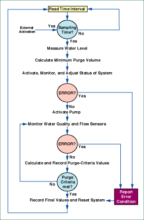
Robowell uses a computer to control a pump and a series of electronic instruments, which monitor the quality of ground water pumped through the system from a monitoring well or multilevel sampler. In the full implementation, a Robowell system will (1) activate itself as programmed, (2) perform a series of self-tests, (3) measure the water level in the well, (4) calculate the purge volume, (5) measure and record values of water-quality properties and constituents during the purge cycle, (6) determine and record the final values of the properties and constituents, and (7) return to an inactive mode (fig. 2). Granato and Smith (1999a,b; 2001) describe in detail the design and implementation of Robowell with case studies and potential applications.
|
| Figure 2. Robowell follows established manual sampling protocols and records water level, individual water-quality measurements, and final purge values. Robowell also records diagnostic information and any errors that may occur during the monitoring process. |
The system's computer program uses information from system feedback, water-quality measurements, and an internal clock to control the monitoring process automatically. If the system functions properly, it monitors and records instantaneous measurements of water-quality properties and constituents. After each measurement, Robowell calculates purge-criteria values (for example, the range of the last five measurements). Robowell records final water-quality values and terminates the measurement process when the purge criteria are met. If the system detects equipment errors during a sampling interval, the system records error codes and measured values for the sampling interval. An operator can initiate, suspend, or modify monitoring operations in response to errors in system feedback. The operator can monitor and control the system on site or by remote control through a communications link. Robowell provides three valuable tools for ground-water monitoring:
The first step toward assessing the potential vulnerability of a ground-water supply is to develop an understanding of the hydrology of the contributing area. To achieve this, monitoring wells are drilled and tested to establish the geometry, types of sediment, and hydraulic properties of an aquifer. Water levels from these wells help determine the magnitude and direction of ground-water flow. Historically, a relatively few (in space and time) periodic water-level measurements from wells were used to characterize directions of ground-water flow, potential contaminant movement, and the degree of interaction between ground and surface water. Recent research, however, suggests that continuous water-level data may be necessary to learn how ground-water flow responds to changing river stage (or ocean tides), short-term and seasonal aquifer-recharge rates, barometric pressure, well pumping or injection rates, and other stresses on the ground-water system that affect estimates of ground-water flow and potential contaminant movement (Myers and others, 1999; Taylor and Alley, 2001). For example, Myers and others (1999) deployed a network of real-time, ground-water-level monitoring wells and detected large changes in the direction (greater than 40 degrees) and magnitude (about 50 percent of the median gradient) of flow during an 8-month study of a surficial aquifer in Kansas. Large changes in the direction and magnitude of ground-water flows have also been detected between periods of relatively high- and low-water table conditions on Cape Cod, Massachusetts (McCobb and others, 1999).
Robowell units have successfully provided real-time water-level data to monitor
conditions at different study sites (Granato and Smith, 2001).
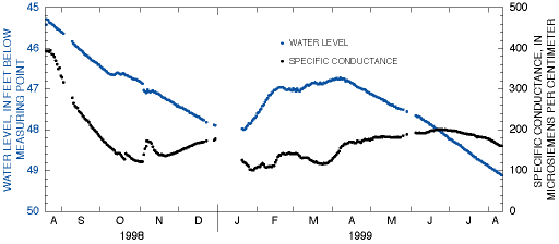
At Walden Pond, in Concord, Massachusetts, the real-time water levels and associated
water-quality measurements supplied by a Robowell were instrumental in detecting
a change in the direction of ground-water flow. Robowell was implemented as
part of a study to determine the source of nutrients to the pond. The unit was
emplaced to monitor short-term and seasonal variability in ground-water quality
downgradient of the State Park's septic leach field near the pond. Substantial
decreases in water levels and specific conductance (a measure of total dissolved
solids) during August and September 1998 (fig. 3) indicated a change in the
direction of ground-water flow. The decrease in specific conductance was surprising,
given the heavy use of the bathhouse facilities and the subsequent high-effluent
loading rates from the septic system during the summer. Increased manual ground-water-level
monitoring and installation and sampling of new wells in the area confirmed
that the direction of ground-water flow had changed, and that the Robowell prototype
was now on the edge, rather than in the center, of the septic-system-effluent
plume. The data from Robowell and from the increased manual sampling indicated
that the effluent plume was traveling toward the pond. This finding prompted
seepage studies at the edge of the pond to detect the arrival of this plume.
|
| Figure 3. From August 1998 through August 1999, Robowell monitored water level and specific conductance at USGS well 422627071195901 near Walden Pond, Concord, Massachusetts. Decreasing water levels and specific conductance during August and September 1998 suggested a change in the direction of ground-water flow. |
Robowell can detect changes in ground-water quality because it produces a record of water-quality measurements that are taken at a user-specified frequency. Because additional measurements cost almost nothing, Robowell units can measure on an hourly, daily, or weekly interval, as needed, to characterize changes in water quality. The system can be programmed to automatically increase the frequency of measurements if it detects changes in water quality. The real-time water-quality monitoring records produced by Robowell can provide the context for interpreting results from laboratory analysis of periodic manual samples. For example, records of real-time measurements can be used with analyses of discrete samples obtained manually to identify the abrupt arrival of a contaminant plume, subtle trends caused by a diffuse source of contaminants, or an error made in the analysis of a sample.
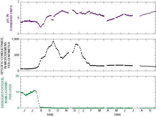
The Robowell technology has many potential applications for monitoring possible sources of ground-water contamination, and for guarding the source areas of public supply wells (Granato and Smith, 2001). In Massachusetts, Robowell units have reliably monitored the effects of road salt, sewage effluent, septic effluent, and saltwater intrusion on ground-water quality. Units have also monitored the effects of natural biological restoration of a contaminated aquifer and geochemical effects of an experimental remediation technique. For example, the Robowell data presented in figure 4 show changes in water quality measured in a well on Cape Cod, Massachusetts. The real-time data collected by this Robowell prototype provided the information necessary to characterize ground-water quality at the site. It also provided a context for interpreting the results of laboratory analyses of samples collected in the adjacent well cluster (Granato and Smith, 1999b). Robowell may also help monitor other sources of contaminants such as nonpoint-source pollution, infiltration from stormwater-retention structures, potential leakage at municipal landfill sites, chemical spills or chemical-disposal sites, and waste sites for military munitions (Granato and Smith, 2001).
|
| Figure 4. From June 1998 through September 1999, a Robowell prototype at USGS well 414047070321304 on Cape Cod, Massachusetts, measured changes in pH, specific conductance, and dissolved oxygen. |
Access to real-time ground-water data may be necessary to protect vulnerable ground-water supplies and to optimize operation of public water-supply wells. Robowell units can use telephone lines, cellular phones, radio connections, or satellite links to transmit data in real-time. If phone connections are used, Robowell units can provide timely information by voice-modem contact, direct data-modem connection, or by links to the internet. For example, quarterly manual samples collected from USGS well 414047070321304 on Cape Cod, Massachusetts at the end of July and October 1998, and in January 1999 would not detect changes in water quality (apparent as the two peaks in specific conductance in the real-time record on figure 4) in a timely manner. In this case, if one assumes a one-month delay between manual sample collection and receipt of a water-quality analysis from a laboratory, the person relying on this quarterly manual sampling program may not be aware of a change in water quality until December 1998. The person relying on the real-time Robowell data, however, could have detected and responded to a change in water quality in early August 1998. In fact, the Robowell monitoring ground water quality at this site (fig. 4) used a voice modem to contact the project chief in early August when specific conductance measurements initially exceeded 100 and then exceeded 200 microsiemens per centimeter (Granato and Smith, 1999b; 2001). These voice-modem alerts (preprogrammed messages in English) on an answering machine and subsequent telephone access to the real-time data allowed the project chief to optimize manual-sampling efforts and minimize laboratory-analysis expenses. This sampling program was improved because the project chief could dispatch sampling teams to the remote site when the plume arrived and ground-water quality changed substantially.
Another example of the utility of real-time access to data is provided by a Robowell used to monitor the freshwater/saltwater interface in a public water-supply well in Provincetown, Massachusetts. For over a year, the unit has provided real-time water levels and water-quality data on the internet. These data provide a direct indication of hydraulic head in the aquifer, which theoretically controls the position of the freshwater/saltwater interface. Graphs of water quality in the screened zones of the monitoring wells record changes in salinity caused by movement of the freshwater/saltwater interface. A number of operational parameters including equipment-shelter air temperature and humidity, battery voltage, bladder-pump gas pressure and flow rates, and diagnostic error codes are available to the system operators on a web page to facilitate maintenance for this remote unit. The real-time data from Provincetown, sound files demonstrating the telephone voice-modem connection, and detailed information on the Robowell technology are available on-line at URL http://ma.water.usgs.gov/automon/.
Protecting public health and the Nation's water-supply infrastructure requires accurate and current hydrologic data. As ground-water supplies become increasingly vulnerable to contaminants from many land uses, and as continuing development in many areas limits pristine sites for water-supply development, the need for real-time ground-water data increases. Robowell, an automated water-monitoring system, can help meet this need. Using established ground-water sampling protocols, this technology can provide real-time information about ground-water levels and water quality needed to protect ground-water supplies.
By Gregory E. Granato and Kirk P. Smith
Barlow P.M., 2000, Ground-water resources for the futureAtlantic coastal zone: U.S. Geological Survey Fact Sheet 085-00, 4 p.
DeSimone, L.A., and Ostiguy, L.J., 1999, A vulnerability assessment of public-supply wells in Rhode Island: U.S. Geological Survey Water-Resources Investigations Report 99-4160, 153 p.
Granato G.E., and Smith, K.P., 1999a, RobowellAn automated process for monitoring ground-water quality using established sampling protocols: Ground Water Monitoring and Remediation, v. 19, no. 4, p. 8189.
Granato, G.E., and Smith, K.P., 1999b, RobowellA reliable and accurate automated data-collection process applied to reactive-wall monitoring at the Massachusetts Military Reservation, Cape Cod, Massachusetts, in Morganwalp, D.W., and Buxton, H.T., eds., U.S. Geological Survey Toxic Substances Hydrology ProgramProceedings of the Technical Meeting, March 812, 1999, Charleston, South CarolinaVolume 3, Subsurface Contamination from Point Sources: U.S. Geological Survey Water-Resources Investigations Report 99-4018C, p. 447456.
Granato, G.E., and Smith, K.P., 2000, Automated ground-water monitoring system and method: Washington, D.C., U.S. Government Patent and Trademark Office, U.S. Patent 6,021,664, 31p.
Granato, G.E., and Smith, K.P., 2001, Automated ground-water monitoring with Robowellcase studies and potential applications: in Jensen, J.O., and Burggraf, L.W., eds., Chemical and biological early warning monitoring for water, food, and groundProceedings 4574: Bellingham, WA, Society of Photooptical Instrumentation Engineers, Photonics Boston, October 28, 2001, p. 3241.
Harris, S.L., and Steeves, P.A., 1994, Identifying potential public water-supply areas of the Cape Cod aquifer system, Massachusetts, using a geographic information system: U.S. Geological Survey Water-Resources Investigations Report 94-4156, 28 p.
Izbicki, J.A., 2000, Water resources of the Blackstone River Basin, Massachusetts: U.S. Geological Survey Water-Resources Investigations Report 93-4167, 115 p.
Lent, R.M., Waldron, M.C., and Rader, J.C., 1997, Public-water supplies in Massachusetts and Rhode IslandInvestigations of processes affecting source-water quality: U.S. Geological Survey Fact Sheet FS-054-97, 4 p.
McCobb, T.D., LeBlanc, D.R., and Hess, K.M., 1999, Determination of temporal and spatial variability of hydraulic gradients in an unconfined aquifer using three-point triangulation, Cape Cod, Massachusetts, in Morganwalp, D.W., and Buxton, H.T., eds., U.S. Geological Survey Toxic Substances Hydrology ProgramProceedings of the Technical Meeting, March 812, 1999, Charleston, South Carolina: Volume 3, Subsurface Contamination from Point Sources: U.S. Geological Survey Water-Resources Investigations Report 99-4018C, p. 349360.
Myers, N.C., Finnegan, P.J., and Breedlove, J.D., 1999, Analysis of water-level data and ground-water flow modeling at Fort Riley, Kansas: U.S. Geological Survey Water-Resources Investigations Report 99-4115, 6 p.
Smith, K.P., and Granato G.E., 1998, Technology transfer opportunitiesAutomated groundwater monitoring, a proven technology: U.S. Geological Survey Fact Sheet FS-122-98, 2 p.
Taylor C.J., and Alley, W.M., 2001, Ground-water-level monitoring and the importance of long-term water-level data: U.S. Geological Survey Circular 1217, 68 p.
Trench, E.C.T., 1991, Ground-water resources of Rhode Island: U.S. Geological Survey Open-File Report 91-199, 169 p.
For more information about licensing of this and other patents and for cooperative research opportunities with the USGS, please contact:
Technology Enterprise Office (TEO),
jgiller@usgs.gov
U.S. Geological Survey
12201 Sunrise Valley Drive, MS 211
Reston, VA 20192
Tel: (703) 648-4403
Fax: (703) 648-4408
For information about the technical details of Robowell, please contact:
Kirk P. Smith, kpsmith@usgs.gov
Gregory E. Granato, ggranato@usgs.gov
U.S. Geological Survey
Massachusetts, Rhode Island District
10
Bearfoot Road
Northborough, MA 01532
Tel:
(508) 490-5000
Fax:
(508) 490-5068
The Robowell investigations described in this Fact Sheet were
done in cooperation with the USGS Technology Enterprise Office,
the USGS Toxic Substances in Hydrology Program, the Air Force
Center for Environmental Excellence, the Massachusetts Highway
Department, the Provincetown Water Department, and the Massachusetts
Department of Environmental Management.
USGS Fact Sheet FS-053-02
July 2002
The citation for this report, in USGS format, is as follows:
Granato, G.E., and Smith, K.P., 2002, Robowell--Providing Accurate and
Current Water-Level and Water-Quality Data in Real Time for Protecting
Ground-Water Resources: U.S. Geological Survey Fact Sheet FS-053-02, 6 p.
For more information about Robowell and related programs, visit the following Web sites:
The Robowell Web site at URL http://ma.water.usgs.gov/automon/
The Technology Enterprise office Web site at URL http://www.usgs.gov/tech-transfer/
and the Toxic Substances Hydrology Program Web site at URL http://toxics.usgs.gov/
| AccessibilityFOIAPrivacyPolicies and Notices | |
 |
|