
U.S. Geological Survey
Fact Sheet 64-03
July 2003 - Online Version 1.0
The Marine Realms Information Bank --
A Coastal and Marine Digital Library
What is the MRIB?
The Marine Realms Information Bank (MRIB) is a digital library designed to classify, integrate, and facilitate access to scientific information about the oceans and the adjacent parts of the atmosphere and solid Earth, as well as to the people, techniques, and organizations involved in
marine science. By integrating information science and communication technology, the MRIB creates a new vision of libraries and scientific publishing and provides a dynamic environment for the
global sharing of digital information. The MRIB, which is a joint effort of the U.S.
Geological Survey (USGS) and the Woods Hole Oceanographic Institution (WHOI), is available on the World Wide Web at http://mrib.usgs.gov/.
What is a Distributed Geolibrary?
The MRIB is a distributed geolibrary as defined by the National Research Council (1999). As such, the MRIB (1) prioritizes the search and display of information by place (particular locations on
the Earth's surface) and (2) links information existing in remote physical locations by removing geographic and temporal boundaries. In spite of this distributed nature, the basic services of the MRIB remain similar to those of a traditional library. Any piece of relevant information accessible online (text, pictures, charts, maps, or binary data files) can be classified by specialists and placed on virtual shelves designed to allow users to browse through holdings with shared subjects, locations, or other characteristics.
How does the MRIB work?
The conceptual design of the MRIB is that of a system capable of classifying and integrating existing information without altering its attributes or integrity. All information pertaining to coastal and marine environments is organized by the following 13 criteria: location, geologic
time, physiographic feature, biota, discipline, research method, hot topics, project title, agency name, author, class, format, and audience. The collection of software constituting the MRIB grew out of the Woods Hole Oceanographic Institution’s 4DGeo-Browser project (Lerner and Maffei,
2001), which is based on the electronic index card (EIC). An EIC is the electronic counterpart of the physical index card used in library card catalogs. Any digital information referenced in the MRIB is assigned an EIC containing descriptive metadata, including geospatial data (area of study) and the document’s network location (Uniform Resource Locator or URL).
What does an MRIB user see?
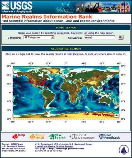
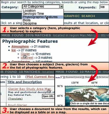
The MRIB Web interface (fig. 1) is designed to encourage browsing as well as searching, thus preserving the strengths of a traditional library catalog while taking advantage of the flexibility of digital technology. Currently, the MRIB offers three types of searches—by category, by keyword, and by location. Users can select categories from any depth within the classification hierarchies, search the metadata database for a keyword, or select a region by choosing a predefined location name listed in a gazetteer or by clicking on a map. These operations can be
applied repeatedly, in any order, until the selection is appropriately focused. After each step, the MRIB displays maps and tables containing links and descriptions of the information resources matching the selection criteria (figs. 2 and 3).
|
|
Figure 1. The MRIB Web interface.
|
|
|
Figure 2. The MRIB Web interface is designed to encourage browsing as well as searching.
|
|
|
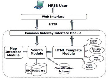
Figure 3. MRIB Software Architecture. The MRIB query process begins with the user issuing a
search request on the Web browser. The Common Gateway Interface module parses this
request and passes it on to the search module. The search module queries the electronic index
card database for matching records; for geographical searches, the map interface module is
also invoked to handle latitude and longitude parameters. Once the matching records are
retrieved, the search module calls upon one of several templates chosen by the user (table,
map, or category view). Finally, the Web page of results is sent back to the user.
|
What is the importance of the MRIB?
The initial focus of the MRIB has been on USGS coastal and marine geology information, but data from other scientific agencies, including WHOI, are also being indexed. MRIB Version 1 was
released on January 2003. The significance of the MRIB project lies in the utility of the digital library itself and in the implementation of the distributed geolibraries concept. Systems similar to the MRIB can be used as unifying catalogs for extensive or rapidly developing information bases where a centralized repository is impractical. The MRIB is a timely endeavor that will aid in accessing scientific information and in understanding the complicated issues involved in managing
natural resources and promoting public health, safety, and the well-being of our planet and its inhabitants.
References Cited
Lerner, S., and Maffei, A., 2001, 4DGeo-Browser--A Web-based data browser and server for accessing and analyzing multi-disciplinary data: Woods Hole Oceanographic Institution, Woods Hole, MA, Technical Report WHOI-2001-13, 71 p.
National Research Council, 1999, Distributed geolibraries—Spatial information resources: National Academy Press, Washington, DC, 136 p.
For additional information, please contact:
Frances L. Lightsom
U.S. Geological Survey
384 Woods Hole Road
Woods Hole, MA 02540-1598
E-mail: flightsom@usgs.gov
Telephone: 508-457-2242
Fax: 508-457-2310
U.S. Department of the Interior, U.S. Geological Survey
URL: https://pubsdata.usgs.gov/pubs/fs/fs064-03/fs064-03.html
For more information, contact Frances L. Lightsom
Maintained by Eastern Publications Group
Last modified: 17:56:17 Tue 29 Nov 2016
Privacy statement | General disclaimer | Accessibility