 |
|
|
||||
| Publications— Fact Sheet |
Prepared in cooperation with the NORTH PLATTE NATURAL RESOURCES DISTRICT
U.S. Geological Survey Fact Sheet 100-01
By Ingrid M. Verstraeten1, John Karl Bo¨hlke2, Thomas F. Kraemer2, and James C. Cannia3
This report is available online in Portable Document Format (PDF). If you do not have the Adobe Acrobat PDF Reader, it is available for free download from Adobe Systems Incorporated.
View the full report in PDF 5.1 MB
The effects of irrigation canals and the North Platte River on ground-water movement and quality in an irrigated alluvial valley, western Nebraska, were evaluated using environmental tracers. The results indicated that most of the ground water in the alluvium was derived from the North Platte River and generally was less than 30 years old. Ground-water-recharge rates varied substantially from about 0.6 to 9 feet per year with the larger recharge rates reflecting localized canal seepage.
Younger water had higher nitrate concentrations than older water. Increases in nitrate concentrations in recharging ground water over time may be associated with an increase in nitrogen fertilizer use over time. Denitrification was limited in the ground water in the alluvium.
Uranium concentrations in ground water resulted from dissolution of volcanic ash or other sediments in the underlying bedrock or incorporated in the alluvium. High uranium concentrations in the North Platte River during the winter months were a result of the addition of uranium-rich water from local tributaries and seepage of uranium-rich ground water.
Nitrate and uranium concentrations in ground water have adversely affected drinking-water supplies of residents in and near the Dutch Flats area in western Nebraska (fig. 1), requiring the relocation or drilling of additional public-supply wells. Some nitrate-N (nitrogen) concentrations higher than 10 mg/L (milligrams per liter; equivalent to parts per million), which is the U.S. Environmental Protection Agency (USEPA) Maximum Contaminant Level (MCL), were found in ground water (Verstraeten and others, 1995). Some uranium concentrations higher than 30 µg/L (micrograms per liter; equivalent to parts per billion), the USEPA MCL, were found in ground water and the North Platte River (Steele and Cannia, 1997; Verstraeten and others, 1995, 2001b; Verstraeten, Bohlke, and Kraemer, in press).
 |
(Click on for larger image) |
The U.S. Geological Survey, in cooperation with the North Platte Natural Resources District (NPNRD), conducted an investigation of an irrigated alluvial valley using environmental tracers, such as tritium and chlorofluorocarbons along with selected stable isotopes of hydrogen, helium, oxygen, nitrogen, and uranium. The objectives of the study were (1) to develop a better understanding of the effects of irrigation canals and the North Platte River on ground water, and (2) to evaluate sources and movement of water, nitrogen, and uranium. Multi-tracer methods were applied in an area where surface-water irrigation has significant effects on the quantity and quality of the ground water.
The approach included sampling of surface water and ground water at different scales of space and time from 1995 through 1999. Sources of water were determined by examining hydrogen and oxygen stable isotopes and dissolved atmospheric-gas concentrations. Ground-water-recharge rates and residence times were estimated by application of tritium-helium dating confirmed by limited chlorofluorocarbon data. Sources and sinks of nitrate were investigated using nitrogen stable isotopes and dissolved-gas concentrations. Sources and fluxes of uranium, including the uranium budget of surface water, were determined in part from the distribution of uranium isotope ratios.
This fact sheet summarizes selected results of the Dutch Flats study pertaining mainly to sources of water, nitrate, and uranium. More detailed information can be obtained from other reports (Verstraeten and others, 2000, 2001a, 2001b; Steele and others, 2001; Verstraeten, Bohlke, and Kraemer, in press).
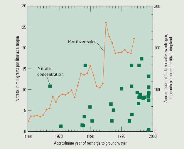
The study was conducted in a 212-square-mile agricultural area of the North Platte River alluvial valley in western Nebraska (fig. 1). The major geologic units in the study area are Quaternary-age alluvium and several bedrock units, including the Brule and Chadron Formations of Tertiary age (Verstraeten and others, 1995). Irrigation canals, built in the early 20th century, provide more than 80 percent of the irrigation water in Scotts Bluff County. Water diverted from the North Platte River in Wyoming generally flows through these canals from April or June through September. Additional irrigation water is obtained from wells. From 1960 to 1994, commercial nitrogen fertilizer use per unit area of cropland in Scotts Bluff County increased about tenfold, from about 23 pounds of nitrogen per acre in 1960 to about 223 pounds of nitrogen per acre in 1994. Fertilizer containing nitrogen was applied on about 39 percent of the land in Scotts Bluff County in 1997. The most intensively fertilized crops in the area are corn and sugar beets.
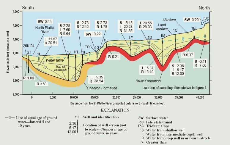
Hydrogen and oxygen isotope data indicated that most of the alluvial ground water originated from the North Platte River either directly as river-channel recharge or as recharge from surface-water irrigation (Verstraeten, Bohlke, and Kraemer, in press). Age dating indicated that ground water in the alluvium generally was less than 30 years old (fig. 2) and that recharge rates varied substantially from 0.6 to 9 feet per year with the larger recharge rates reflecting localized canal leakage. The average age of water in the alluvial aquifer along the transect was 8.8 years, with an average overall estimated mean recharge rate of 2.7 feet per year.
 |
(Click on for larger image) |
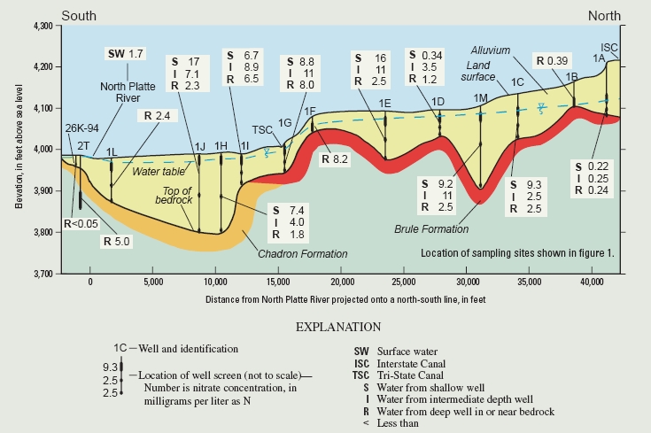
Nitrate concentrations (as N) and nitrogen isotopic compositions (as d15N [NO3-]) in the alluvial ground water in the study area varied from less than 0.05 to 23.7 mg/L (fig. 3; not all data are shown) and from -0.5 to +11.5 per mil (parts per thousand), respectively. Nitrate concentrations generally were higher in shallow, younger (less than 10 years old) water than in the deep, older (more than 10 years old) water (fig. 4) except near the irrigation canals. Most samples had d15N [NO3-] values from about +2 to +6 per mil. Samples with the highest nitrate concentrations typically had d15N [NO3-] values near the lower end of the range. The data indicate that the higher nitrate concentrations in younger compared to older ground water may be associated with a documented regional increase in fertilizer use over time (fig. 4). The inverse relation between nitrate concentration and isotope composition also may be associated with about a fivefold decrease in the relative proportions of manure and artificial fertilizer use over time.
 |
(Click on for larger image) |
 |
(Click on for larger image) |
Denitrification, a biochemical process whereby nitrate is converted to nitrogen gas, did not have a major effect on the concentration of nitrate in the alluvial ground water, except at some places near the bottom of the alluvium. For a recharge rate of 2.3 feet per year (28 inches per year), transport of nitrate to the ground water from fertilizer, mineralization of soil nitrogen, atmospheric deposition, and manure spreading could have yielded nitrate concentrations as high as 19 mg/L in 1960 to 35 mg/L in 1992, not accounting for nitrogen uptake by plants or any other loss of nitrogen. Compared to the observed concentrations in ground water, these calculations indicate transport to the ground water of about 5 to 38 percent of the available nitrogen in the agricultural soils.
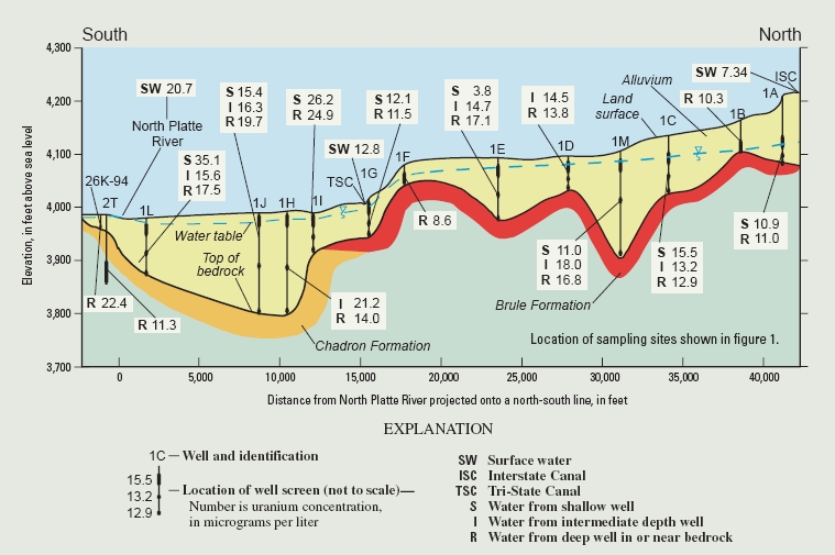
High uranium concentrations in ground water from the alluvium of more than about 10 µg/L probably resulted from dissolution of volcanic ash or other sediments in the underlying bedrock or incorporated in the alluvium (fig. 5). On the basis of data collected during this study, seepage from canals locally resulted in decreased uranium and nitrate concentrations in ground water. High concentrations of uranium generally were found in the valley of the North Platte River, where the Chadron Formation, which contains uraniferous sediments, underlies the alluvium. High uranium concentrations in the North Platte River of as much as 31.1 µg/L in the winter resulted from uranium-rich surface-water inputs from tributaries, such as Owl Creek and Horse Creek near Lyman, Nebraska, in combination with low flows of the North Platte River. These streams drain areas of Nebraska and Wyoming where Cretaceous marine sediments containing uranium are exposed. Seepage of uranium-rich ground water also contributed to the high uranium concentrations in the North Platte River under low-flow conditions.
 |
(Click on for larger image) |
The use of multiple-tracer methods to determine sources and movement of water, nitrogen, and uranium is helpful in resolving hydrologic questions concerning water and contaminant sources. These methods are valuable to water-resources managers concerned with surface-water irrigation and return flow, and drinking-water quality. Results provided improved understanding of the water resources at and near the Dutch Flats area and their management in the future:
| (1) | The evaluation of isotopes of hydrogen and oxygen improved the understanding of sources of ground water and the positive effects of surface-water irrigation and seepage from canals on ground-water quantity; and |
| (2) | The evaluation of nitrate, nitrogen isotopes, uranium, and uranium isotopes (not discussed) resulted in a better understanding of the sources and fluxes of nitrogen and uranium. |
The authors thank the NPNRD for their cooperation and contributions to this study, especially Ronald D. Cacek and Kimberly G. Scripter. The NPNRD received a Clean Water Act 319 grant used in part to finance the installation of nested wells and the collection of ground-water-quality data.
Steele, G.V., and Cannia, J.C., 1997, Reconnaissance of surface-water quality in the North Platte Natural Resources District, western Nebraska, 1993: U.S. Geological Survey Water-Resources Investigations Report 96-4316, 21 p.
Steele, G.V., Verstraeten, I.M., and Cannia, J.C., 2001, Surface-water/ground-water interaction and implication for ground-water sustainability in the Dutch Flats area, western Nebraska: U.S. Geological Survey Fact Sheet 074-01, 4 p.
Verstraeten, I.M., Bohlke, J.K., and Kraemer, T.F., 2000, Groundwater/surface-water interactions and sources of nitrogen and uranium in an irrigated area of Nebraska, USA, in Dassargues, Alain, ed., Tracers and modelling in hydrogeologyŃproceedings of the TraM'2000 Conference held in Liege, Belgium, May 23-26, 2000: International Association for Hydrologic Sciences (IAHS) Publication No. 262, p. 525-531.
In press, Use of environmental tracers and isotopes to evaluate sources and movement of water, N, and U, in an irrigated alluvial valley, Nebraska, USA: Journal of Hydrology.
Verstraeten, I.M., Sibray, S.S., Cannia, J.C., and Tanner, D.Q., 1995, Reconnaissance of the ground-water quality in the North Platte Natural Resources District, western Nebraska, June-July1991: U.S. Geological Survey Water-Resources Investigations Report 94-4057, 114 p.
Verstraeten, I.M., Steele, G.V., Bohlke, J.K., Kraemer, T.F., Cannia, J.C., Hitch, D.E., Wilson, K.E., and Carnes, A.E., 2001a, Selected field and analytical methods and analytical results, Dutch Flats area, western Nebraska, 1995-99: U.S. Geological Survey Open-File Report 00-413, 53 p.
Verstraeten, I.M., Steele, G.V., Cannia, J.C., Hitch, D.E., Scripter, K.G., Bohlke, J.K., Kraemer, T.F., and Stanton, J.S., 2001b, Interaction of surface water and ground water in the Dutch Flats area, western Nebraska, 1995-99: U.S. Geological Survey Water-Resources Investigations Report 01-4070, 56 p.
For further information contact: |
1U.S. Geological Survey, Lincoln, Nebraska. 2U.S. Geological Survey, Reston, Virginia. 3North Platte Natural Resources District, Gering, Nebraska. |
| AccessibilityFOIAPrivacyPolicies and Notices | |
| U.S. Department of the Interior, U.S. Geological Survey
Persistent URL: https://pubs.water.usgs.gov/fs100-01 Page Contact Information: USGS Publishing Network Last modified: Tuesday, 29-Nov-2016 17:57:07 EST |
 |