Satellite Image Maps of Pakistan
U.S. Geological Survey Factsheet 109-97
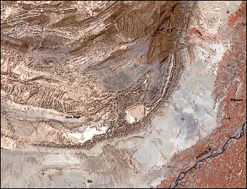 |
Portion of the Sulaiman lobe, north of Sui, Landsat MSS Image, February 1975; from Miscellaneous Investigations Map I-2587-E (reduced). |
Georeferenced Landsat satellite image maps of Pakistan are now being made available for purchase from the U.S. Geological Survey (USGS). The first maps to be released are a series of Multi-Spectral Scanner (MSS) color image maps compiled from Landsat scenes taken before 1979. The Pakistan image maps were originally developed by USGS as an aid for geologic and general terrain mapping in support of the Coal Resource Exploration and Development Program in Pakistan (COALREAP). COALREAP, a cooperative program between the USGS, the United States Agency for International Development, and the Geological Survey of Pakistan, was in effect from 1985 through 1994.
The Pakistan MSS image maps (bands 1, 2, and 4) are available as a full-country mosaic of 72 Landsat scenes at a scale of 1:2,000,000, and in 7 regional sheets covering various portions of the entire country at a scale of 1:500,000. The scenes used to compile the maps were selected from imagery available at the Eros Data Center (EDC), Sioux Falls, S. Dak. Where possible, preference was given to cloud-free and snow-free scenes that displayed similar stages of seasonal vegetation development.
The data for the MSS scenes were resampled from the original 80-meter resolution to 50-meter picture elements (pixels) and digitally transformed to a geometrically corrected Lambert conformal conic projection. The cubic convolution algorithm was used during rotation and resampling. The 50-meter pixel size allows for such data to be imaged at a scale of 1:250,000 without degradation; for cost and convenience considerations, however, the maps were printed at 1:500,000 scale. The seven regional sheets have been named according to the main province or area covered. The 50-meter data were averaged to 150-meter pixels to generate the country image on a single sheet at 1:2,000,000 scale.
 Map-I-2587-A. Map-I-2587-A.
|
These maps were originally developed as digital data or color photographic
prints that were limited to use by the cooperating government agencies in
support of the general objectives of COALREAP. Their subsequent publication was
made possible by an internal USGS grant for developing value-added byproducts
from completed projects. The Pakistan imagery was selected for this grant in
response to expressions of interest that were received from the public after the
completion of COALREAP. Much of the interest in the Pakistan imagery was related
to public- and private-sector initiatives for the development of infrastructure,
natural 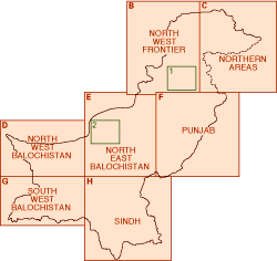 resources, and
baseline environmental studies. The maps are also intended to serve as a general
demonstration of USGS capabilities for the production of geocorrected image
maps. The Pakistan image maps are well-suited for this purpose because of the
investment in processing that was already made during COALREAP and the diversity
of physiographic and geologic terrain within the map areas.
resources, and
baseline environmental studies. The maps are also intended to serve as a general
demonstration of USGS capabilities for the production of geocorrected image
maps. The Pakistan image maps are well-suited for this purpose because of the
investment in processing that was already made during COALREAP and the diversity
of physiographic and geologic terrain within the map areas.
The full-country MSS mosaic at a scale of 1:2,000,000 is available as U.S. Geological Survey Miscellaneous Investigations Map I-2587-A. Individual sheets at a scale of 1:500,000 are available in the series as I-2587-B through H, with the letter suffix as shown in the index map below. Two related image products for Pakistan are shown on the index map as numbered insets, and additional related products are forthcoming. See below for ordering information and a preliminary list of related products.
| Related products in press: | Maps may be ordered by mail from: | ||
| (1) U.S. Geological Survey Bulletin 2078,
Regional studies of the Potwar Plateau area, northern Pakistan (by P.D.
Warwick and B.R. Wardlaw, eds.) will include a Universal Transverse
Mercator (UTM) MSS image and several thematic overlays at a scale of
1:250,000.
(2) U.S. Geological Survey Miscellaneous Investigations Map I-2549, Geologic map and landsat image of parts of Loralai, Sibi, Quetta, and Khuzar Divisions, Balochistan Province, west central Pakistan (by F. Maldonado, S.H. Khan, J.M. Mengal, and J.C. Thomas) consists of two sheets -- sheet 1, geologic map; sheet 2, Thematic Mapper image, UTM projection at a scale of 1:250,000. Additional satellite image products of Pakistan are in preparation. For pricing information or ordering assistance, write to the mail-order address that follows or call: 1-888-ASK-USGS,1-800-HELP-MAP, or 303-202-4700 E-mail: infoservices@usgs.gov |
USGS Information Services | ||
| Box 25286, Federal Center | |||
| Denver, CO 80225 | |||
| USA | |||
| For technical information or
information on related products contact: | |||
| John SanFilipo | E-mail: jsan@usgs.gov | ||
| U.S.Geological Survey | Fax: 703-648-6419 | ||
| 956 National Center | |||
| Reston, VA 20192 | |||
| Jean Claude Thomas | E-mail: jcthomas@usgs.gov | ||
| U.S. Geological Survey | Fax: 703-648-4165 | ||
| 521 National Center | |||
| Reston, VA 20192 | |||
| Peter Warwick | E-mail: pwarwick@usgs.gov | ||
| U.S. Geological Survey | Fax: 703-648-6419 | ||
| 956 National Center | |||
| Reston, VA 20192 | |||
Created by the EERT WWW Staff.
[an error occurred while processing this directive]