
Contaminant Distribution and Accumulation in Sediments of Long Island Sound: Initial Results
The Impact of Human Activity in Long Island Sound
The water and sediment quality of coastal waters near many urban centers in the United States are affected by industrial and agricultural activities. Semi-enclosed marine areas, such as Long Island Sound, are particularly sensitive to the effects of human activity because they are not as well flushed as open coasts. The larger cities of New York, New Haven, and New London are located on Long Island Sound, as are numerous smaller cities and towns on both the northern and southern shores (fig. 1). In addition, the Housatonic, Connecticut, Thames, and other rivers drain extensive inland areas into the sound.
|
|
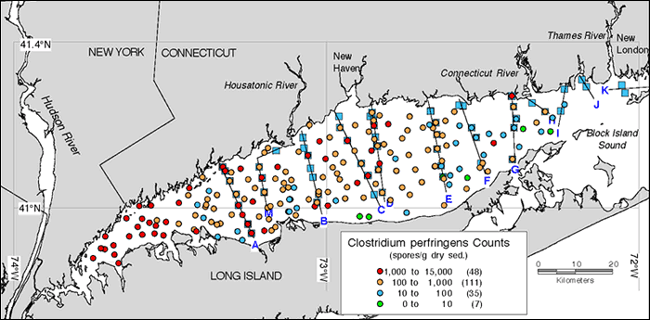
Figure 1. Map showing the distribution of Clostridium perfringens in Long Island Sound. Dots show the locations of surface (0-2 cm) samples collected in 1996 and 1997. The number of samples in each range is given in parentheses. Values indicate the relative influence of sewage input to a marine system. Values range from near-background detection limit (ľ10 spores/g dry sediment) to concentrations ten thousand times greater. The blue squares and black lines indicate core locations and transect lines chosen for their proximity to major urban centers and river inputs.
|
The need for managers to understand the growing environmental degradation in Long Island Sound prompted the U.S. Geological Survey to undertake a multidisciplinary study of the environmental conditions and the geologic processes that influence these conditions in the sound. This program has three broad objectives outlined below.
Objective 1: Identify and Map Contaminants
One component of this ongoing study is an assessment of selected contaminants in Long Island Sound sediments. This information will determine background values for contaminants, identify sources, determine transport and dispersal paths, identify areas of extensive contaminant accumulation, and provide a basis for model predictions of burial and remobilization rates. The spatial distributions of many contaminants were measured in surficial sediments and cores collected in 1996 and 1997 throughout the sound (fig. 2). A data base of contaminated sediment measurements in the sound is being compiled from the scientific literature and other historical records; the data base will supplement the 1996 samples and provide a tool for research and management.
Surface samples and cores are being analyzed for major elements, manmade contaminants, selected organic compounds, radioisotopes, grain size, and microfossils that indicate environmental conditions. Eventually, radiochemical and lithological data will allow historical horizons to be identified so that contaminant accumulation rates and mobility can be determined.
|
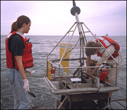
Figure 2. Photograph of the modified Van Veen grab sampler used to collect samples from the sediment surface, as well as to videotape and take still photographs of the sea floor.
|
Objective 2: Processes of Contaminant Dispersal
Clostridium perfringens is a bacterium that is naturally present in the intestinal tract of mammals. Its spores are inert in marine sediments and serve as excellent tracers of sewage input into an ecosystem. Because sewage in coastal waters is often a major source for other contaminants (such as silver, copper, and mercury), measuring spore concentrations is a valuable screening technique for predicting the magnitude and distribution of other contaminants in sediments.
Elevated Clostridium perfringens concentrations measured in surface sediments (fig. 1) and core samples (fig. 3) indicate widespread and long-term addition of human components to the sedimentary system in Long Island Sound. Clostridium perfringens concentrations are highest in the western end of the sound, very low or nondetectable in the eastern part, and within normal limits in the central part. This pattern is attributed to two factors.
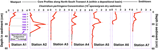
Figure 3. Clostridium perfringens concentration profiles in sediment cores in a north-south transect from Westport (Conn.) to Smithtown (N.Y.). Station A1 has laminations in x-radiographs of the core, a mixing depth of near one cm, a 210Pb profile indicating a constant accumulation rate over the upper 20 cm of the core, and a clear 137Cs peak at 7 cm. The accumulation rate and the 137Cs peak were used to determine the ages of the sediments. Black points in the lower regions of the cores indicate values less than the detection limit.
|
First, the spores are small (4-8 µm long by 1-1.5 µm wide) and are transported along with the fine-grained fraction of sediment (fig. 4). Second, strong bottom currents, especially in the eastern and east-central sound, disperse and mix suspended materials before deposition and burial.
|
Figure 4. Scatter plot showing the correlation (r2=0.5931) between the concentration of Clostridium perfringens spores and the accumulation of fine-grained sediment in Long Island Sound.
|
|
As with Clostridium perfringens, high concentrations of many contaminants are associated with fine-grained sediments (for example, figure 5); this results in contaminant focusing in regions of deposition. Many metals (for example, copper, chromium, and zinc) co-vary, which indicates common sources and transport patterns within the sound. Modern sediments in the western sound typically have concentrations of metals up to three times greater than those sediments deposited in pre-industrial times. The high concentrations in the western sound may be associated with input from New York City sewage sources.

Figure 5. Map showing the distribution of lead in Long Island Sound. Dots show the locations of surface (0-2 cm) samples collected in 1996 and 1997. The number of samples within each range is given in parentheses. Green indicates values that fall within the range of naturally occurring background values in the area, blue indicates slightly elevated lead concentrations, and orange indicates values that may induce some toxic response in organisms exposed to these concentrations.
|
Objective 3: Reconstruct History of Contaminant Deposition
A core transect across the sound shows Clostridium perfringens concentrations above background levels to depths of approximately 20 cm in all locations (fig. 3); however, the bulk concentrations are much greater in the muddier sediments. Steep gradients in contaminant profiles of the muddier cores, which are located in depositional regions, contrast with concentrations that are generally constant with depth in the sandier cores. The uniformity with depth in the sandy profiles observed for both Clostridium perfringens and contaminant metals is consistent with the active reworking of the sea floor that occurs because of bottom currents in the higher energy environments. Profiles of fallout isotopes (137Cs), naturally occurring isotopes (210Pb), and metals indicate that mixing depths vary greatly within Long Island Sound. Age determinations of the sediments show that sewage began to contaminate the sound in the late 1800's, with a marked increase of contaminant concentrations following World War II (fig. 3). In most depositional areas, however, the metal concentrations in sediment cores decrease near the surface, reflecting a reduction in contaminant sources during the 1980's and 1990's.
Figure 3 illustrates the complexity that differing degrees of sediment winnowing, mixing, texture, and source proximity can introduce into the sediment record. Sediment profiles will be used to determine inventories of contaminants in the sound and constraints for calculations of elemental budgets and fluxes for the region.
Future Work and Results
Samples from surface sediments and cores are currently being analyzed for many parameters, and material is available for interested collaborators. The data generated will complement existing data on contaminant distributions in Long Island Sound and allow a detailed reconstruction of the contaminant and sediment history of the sound over the last hundred years. The suite of data that is being generated for contaminants will provide a comprehensive regional view of the sources, fate, and transport of these potential toxins in Long Island Sound sediments.
U.S. Department of the Interior
U.S. Geological Survey
|
|
|
|
|
|
|
|
|
|
|
|
|
|
|
|
|
|
|
|
|
|
|
|
|
|
USGS Fact Sheet 113-99
|
This page is https://pubs.usgs.gov/factsheet/fs113-99/
Maintained by Eastern Publications Group Web Team
Last revised 5-03-99