![[Image: Thumbnail of bird2.jpg]](bird2.jpg)
![[Image: USGS Banner]](banner.gif)
In 1987, the Chesapeake Bay Program (CBP), a multiagency restoration effort, established a goal to reduce controllable nutrient loads into the estuary 40 percent by the year 2000. The goal was based on the results of a computer model, that indicated a 40-percent reduction in nutrient loads would eliminate hypoxia in the mainstem of the bay. The nutrient-load reduction is expected to decrease the severity of algal blooms in the tributaries and encourage the regrowth of SAV. However, resource managers are concerned that the bay and watershed will respond more slowly to the nutrient-reduction measures than was previously anticipated. Therefore, scientific information on lag times between nutrient inputs and water-quality and living-resource response, is needed to assess the effectiveness of nutrient-reduction strategies. Analysis of long-term biological, chemical, and hydrogeologic records integrated with new collected information can help managers gain a perspective on the bounds of inherent variability of the ecosystem and its effect on restoration goals. The U.S. Geological Survey (USGS), through its Ecosystem Program, collects and interprets scientific information to help resource managers determine the success of management strategies and the response of the ecosystem to nutrient reduction.
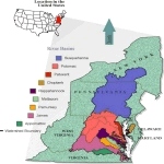
Figure 1
Location of Chesapeake Bay watershed and major river basins.
(Click to see the Full Figure)
(2) Further define and evaluate the natural and anthropogenic controls on the response in water quality and selected living resources to changes in nutrient and sediment sources and climatic variability.
(3) Provide resource managers with the management implications of the scientific findings and develop investigative tools so they may evaluate the effectiveness of different nutrient-reduction strategies.
![[Image: Thumbnail of boat2.jpg]](boat2.jpg)
(Click to see the Full Image)
Through the Ecosystem Program, USGS brings together a team of investigators from relevant complementary disciplines. The investigators coordinate with members of more than 12 programs within the USGS, and scientists and resource managers within the Chesapeake Bay Program.
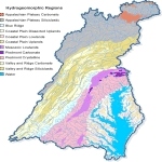
Figure 2
Chesapeake Bay basin with major hydrogeomorphic regions.
(Click to see the Full Figure)
Cartographic, geographic, and associated data are needed to document and evaluate environmental conditions that most affect nutrient and sediment occurrence and selected living resources in the Chesapeake Bay watershed and estuary.
Element 2: Further define the factors that affect the sources, sinks, transport, and residence time of nutrients and sediments in major areas that drain into the Chesapeake Bay and their relation to the estuary.
The river basins in the watershed have been identified as the major source of nutrients and sediments to the estuary. The success of the nutrient- and sediment-reduction practices implemented in the watershed will depend on an improved understanding of the factors affecting input and transport of nutrients and sediments.
Element 3: Quantify the nutrient load entering the Chesapeake Bay from ground water and identify the effect of residence time of nutrients in the ground-water system on water-quality response in the rivers and the bay.
Assessment of the residence time of nutrients in the ground-water system helps managers to understand the lag time between nutrient-reduction actions and water-quality response. A better understanding of the factors controlling nutrient movement and concentration will help resource managers more effectively target the placement of nutrient-reduction measures.
![[Image: Thumbnail of beach2.jpg]](beach2.jpg)
(Click to see the Full Image)
Element 4: Improve the understanding of the hydrologic, geologic, and water-quality factors affecting selected living resources and their associated habitat in the rivers, tidal tributaries, and estuary.
Understanding the response of living resources and associated habitat to water-quality improvements is one of the primary objectives of the nutrient-reduction goal and tributary strategies. In the tidal system, SAV is expected to respond favorably to improved water clarity and quality. Additionally, understanding the link between land use, nutrients, and fish health is needed in the bay system.
Element 5: Study the history and evolution of the Chesapeake Bay ecosystem and its response to changes in sedimentation, salinity, and nutrient loading during the past several decades and centuries.
Investigating the depositional history of the bay will help describe the condition of the bay�s ecosystem prior to human development and improve our knowledge of present conditions. Understanding the influence of climatic cycles on freshwater flow, fluctuations in the bay�s hydrology, nutrients, dissolved oxygen, salinity, sedimentation rates, and biodiversity will help determine the extremes of natural fluctuations and their relation to restoration goals.
Element 6: Information Dissemination and Outreach. There is a continuing need to translate scientific information into usable results to better manage and restore the bay and its watershed. The USGS is working closely with the Communications Subcommittee of the Bay Program and the Alliance for the Chesapeake Bay to relay our scientific results to State and local government resource managers in the bay watershed, program managers in the USGS and the Department of the Interior, scientists, the media, and the general public. The USGS disseminates information through a series of mechanisms including a Home Page on the World Wide Web, fact sheets and reports, press releases and media events, pilot projects with Tributary Strategy Teams, and presentations to agencies and scientists at selected meetings and conferences.
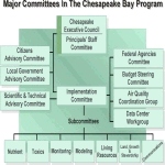
Figure 3
Organizational Chart
(Click to see the Full Figure)
Selected partnerships under Element 1 include evaluation of land-use characteristics being coordinated through the Multi-Resolution Land Characterization (MRLC) effort with the U. S. Environmental Protection Agency (EPA), National Oceanic and Atmospheric Agency (NOAA), and National Aeronautics and Space Agency. The land-use change study in the Patuxent River Basin is being conducted with the University of Maryland at Baltimore County. Nutrient-input data are being obtained from the agencies involved with the Nutrient and Modeling Subcommittees of the Bay Program. Data-access and compatibility issues are being addressed with the agencies of the CBP.
The analysis of nutrient trends under Element 2 is being performed in partnership with the agencies involved in the Monitoring Subcommittee including the Susquehanna River Basin Commission, the Maryland Department of Natural Resources (MD DNR) and the Virginia Department of Environmental Quality. Field investigations to better understand ground- and surface-water interactions will use the data and contribute to existing studies being conducted by the MD DNR, Virginia Department of Environmental Quality, Smithsonian Research Institute, and other Federal and State agencies and research groups.
Investigators under Element 3 are working with the State Geological Surveys in the bay watershed to produce a lithogeochemical map, which will aid in understanding the factors affecting nitrogen movement in the subsurface.
For Element 4, the USGS is an active partner with the Potomac River Integrated Study Team (Interstate Commission on the Potomac River Basin and other agencies) to study SAV in the Potomac River and the SAV workgroup of the Bay Program. At the SAV transplant sites, the USGS will be working with the Alliance for the Chesapeake Bay to collect water-quality data. Finally, the Program will coordinate with the MD DNR, EPA and NOAA to find the causes of fish lesions and kills in the bay. USGS investigators share and report their findings to the CBP Living Resources Subcommittee.
Under Element 5, USGS is working with the Maryland Geological Survey and the University of Maryland to collect and analyze cores in the mid and northern bay. In the southern part of the Bay work is conducted in collaboration with the Virginia Institute of Marine Science. Results will be shared with other institutions working on the long-term history of the bay including Johns Hopkins University and agencies represented on the CBP Living Resources Subcommittee.
The USGS is an active partner with the CBP Communications Subcommittee to disseminate information under Element 6 of the Ecosystem Program. Additionally, the USGS will be working with the Alliance for the Chesapeake Bay to develop products for resource managers and the general public.
U.S. Geological Survey Chesapeake Bay Coordinator
8987 Yellow Brick Road
Baltimore, MD 21237
Web Page address:
http://chesapeake.usgs.gov/chesbay
Scott Phillips and Bill Caughron
FS-124-97
| AccessibilityFOIAPrivacyPolicies and Notices | |
 |
|