
Fact Sheet 136-01
Online Version 1.0
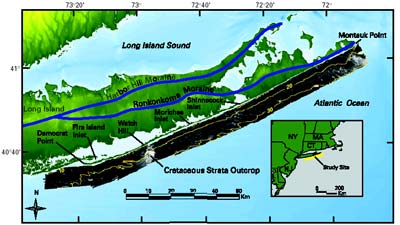
Sand Distribution on the Inner Shelf South of Long Island, New York
By William C. Schwab
|
Long Island, New York, contains deposits left about 20,000 years ago by late Pleistocene (ice age) glaciers at their southern limit in eastern North America. Long Island's south shore consists of reworked glacial sediment and includes shallow brackish-water lagoons and a low-relief barrier-island system. Coastal erosion along the barrier islands has received engineering, scientific, and political attention over the past few decades. Coastal communities, the local fishing industry, and tourism at the area's parks are all affected by coastal erosion.
In 1996, the U.S. Geological Survey and the U.S. Army Corps of Engineers began a program to map the geology of the sea floor along the south shore of Long Island by using a variety of remote-sensing techniques (including high-resolution sidescan-sonar imaging and subbottom profiling) supplemented by sediment sampling. Two main goals were (1) to investigate the roles that the inner shelf morphology and the geologic framework play in the evolution of this coastal region and (2) to assess sand-resource availability offshore for planned beach-nourishment projects. |
|
View a
Download Adobe
Acrobat Reader version 5.0 for free
URL: https://pubsdata.usgs.gov/pubs/fs/fs136-01/index.html
For more information, contact William C. Schwab
Maintained by Eastern Publications Group
Last modified: 17:47:22 Tue 29 Nov 2016
Privacy statement | General disclaimer | Accessibility