Georgia Water Science Center
![]() This report is available online in pdf format (1 MB): USGS Fact Sheet 169-98 (
This report is available online in pdf format (1 MB): USGS Fact Sheet 169-98 (![]() )
)
U.S. Geological Survey Fact Sheet 169-98, 4 pages (Published August 1999)
Estimates of the magnitude and frequency of flood-peak discharges and flood hydrographs are used for a variety of purposes, such as for the design of bridges, culverts, and flood-control structures; and for the management and regulation of flood plains. To provide simple methods of estimating flood-peak discharges, the U.S. Geological Survey (USGS) has developed and published equations for every State, the Commonwealth of Puerto Rico, American Samoa, and a number of metropolitan areas in the United States. In 1993, the USGS, in cooperation with the Federal Emergency Management Agency and the Federal Highway Administration, compiled all current USGS statewide and metropolitan area equations into a computer program, titled “The National Flood-Frequency (NFF) Program” (Jennings and others, 1994).
Since 1993, new or updated equations have been developed by the USGS for various areas of the Nation. These new equations have been incorporated into an updated version of the NFF Program.
Fact sheets that describe application of the updated NFF Program to various areas of the Nation are available. This fact sheet describes the application of the updated NFF Program to streams that drain rural and urban areas in Georgia
Georgia is divided into four hydrologic regions (fig. 1) on the basis of previous flood-frequency studies, geology, soils, physiography, and analysis of flood-frequency regression residuals. Stamey and Hess (1993) developed regression equations for estimating peak discharges (QT), in cubic feet per second, that have recurrence intervals (T) that range from 2 to 500 years for ungaged, unregulated, non-tidal rural streams. The regression equations are not applicable to the Okefenokee Swamp in southeast Georgia. The regression equations also are not applicable to urban, channelized, or large main-stem streams or to streams where large sinkholes or depressions can affect the flood-frequency relation. These features can be identified by the study of geologic and topographic maps or by the reconnaissance of the basin.
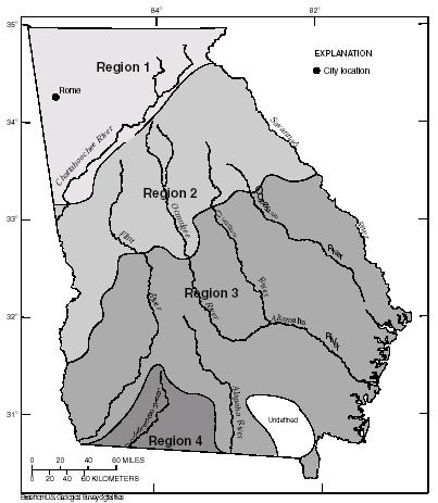 |
| Figure 1. Hydrologic regions for Georgia. |
Drainage area (A) was found to be the most statistically significant explanatory watershed variable and is the only variable that is used in the regression equations. The drainage area is the total area that contributes runoff upstream of the stream site of interest. Drainage areas were measured in square miles for the equations determined by Stamey and Hess (1993), but the NFF Program will accept input and report results in either the inch-pound or metric system of units.
The regression equations, the average standard errors of prediction, the equivalent years of record, and the range of the drainage area that is applicable for use in the equations are shown in table 1. The average standard error of prediction is a measure of the average accuracy of the regression equations when estimating peak-discharge values for ungaged watersheds similar to those that were used to derive the regression equations. The equivalent years of record is the number of years of streamflow record needed to achieve the same accuracy as the regression equation. The standard error of prediction increases appreciably when drainage-area values that are outside the quoted range of data used to develop the equations are applied in the equation.
| Table 1. Flood-peak
discharge regression equations and associated statistics for streams that
drain rural areas in Georgia (modified from Stamey and Hess, 1993) [QT, peak discharge for recurrence interval T, 2 to 500 years, in cubic feet per second; A, drainage area; Do., ditto] |
|||
| Regression equation | Average standard error of prediction, in percent | Equivalent years of record | Applicable range of drainage area, in square miles |
|---|---|---|---|
|
|
|||
| Region 1 | |||
|
|
|||
| Q2 = 207A0.654 | 31 | 3 | 0.17–730 |
| Q5 = 357A0.632 | 29 | 4 | Do. |
| Q10 = 482A0.619 | 29 | 5 | Do. |
| Q25 = 666A0.605 | 29 | 12 | Do. |
| Q50 = 827A0.595 | 30 | 14 | Do. |
| Q100 = 1,010A0.584 | 31 | 16 | Do. |
| Q200 = 1,220A0.575 | 33 | 17 | Do. |
| Q500 = 1,530A0.563 | 36 | 18 | Do. |
|
|
|||
| Region 2 | |||
|
|
|||
| Q2 = 182A0.622 | 33 | 4 | 0.10–3,000 |
| Q5 = 311A0.616 | 28 | 7 | Do. |
| Q10 = 411A0.613 | 27 | 10 | Do. |
| Q25 = 552A0.610 | 28 | 14 | Do. |
| Q50 = 669A0.607 | 30 | 16 | Do. |
| Q100 = 794A0.605 | 33 | 17 | Do. |
| Q200 = 931A0.603 | 36 | 19 | Do. |
| Q500 = 1,130A0.601 | 40 | 21 | Do. |
|
|
|||
| Region 3 | |||
|
|
|||
| Q2 = 76A0.620 | 36 | 3 | 0.14–3,000 |
| Q5 = 133A0.620 | 35 | 6 | Do. |
| Q10 = 176A0.621 | 35 | 10 | Do. |
| Q25 = 237A0.623 | 37 | 15 | Do. |
| Q50 = 287A0.625 | 38 | 18 | Do. |
| Q100 = 340A0.627 | 38 | 19 | Do. |
| Q200 = 396A0.629 | 40 | 19 | Do. |
| Q500 = 474A0.632 | 43 | 20 | Do. |
|
|
|||
| Region 4 | |||
|
|
|||
| Q2 = 142A0.591 | 25 | 8 | 0.25–2,000 |
| Q5 = 288A0.589 | 19 | 27 | Do. |
| Q10 = 410A0.591 | 19 | 37 | Do. |
| Q25 = 591A0.595 | 21 | 43 | Do. |
| Q50 = 748A0.599 | 24 | 40 | Do. |
| Q100 = 926A0.602 | 28 | 37 | Do. |
| Q200 = 1,120A0.606 | 32 | 35 | Do. |
| Q500 = 1,420A0.611 | 37 | 32 | Do. |
|
|
|||
The regression equations were developed by using peak-discharge data for streamflow-gaging stations with at least 10 years of record collected through September 1990 at 357 locations in Georgia and 69 locations in Alabama, Florida, North Carolina, South Carolina, and Tennessee.
Stamey and Hess (1993) developed weighting techniques to improve estimates of peak discharge at gaged locations by combining the estimates derived from analysis of gage records with estimates derived from the regression equations. The weights of these two independent estimates are based on the length of the gage record in years (N) and the equivalent years of records (EQ) of the applicable regression equation. The weighted estimate of peak discharge is computed as:
where
| QT(W) | is the weighted estimate for recurrence interval T at the gage location, |
| QT(S) | is the estimate of QT derived from analysis of the gage records, |
| QT(R) | is the estimate of QT derived from application of the regression equation, |
| N | is the number of years in the gage record, and |
| EQ | is the equivalent years of record (table 1). |
The accuracy of the weighted discharge estimate, in equivalent years of record, is equal to N + EQ.
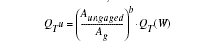
Stamey and Hess (1993) also showed how the weighted estimate for peak discharge at a gaged site can be used to improve estimates of peak discharge for an ungaged site on the same stream that has a drainage that is between 50 and 200 percent of the drainage area of the gaged site. The weighted estimate is computed as:
where
| QT(W)u | is the weighted estimate for recurrence interval T at the ungaged site, |
| ΔA | is the difference in drainage area between the gaged site (Ag) and the ungaged site, (Ag-Aungaged), |
| QT(R)u | is the peak flow estimate for recurrence interval T at the ungaged site derived from the applicable regional equation (table 1), |
| QTu | is the weighted estimate of peak discharge at the gaged site, QT(W), adjusted for the effect of the difference in drainage area between the gaged site and the ungaged site and computed as: |
where
b is the exponent of drainage area in the appropriate regression equation (table 1).
The NFF Program contains algorithms for each of the weighting computations. The equation estimates are used without adjustment where the drainage area at the ungaged site is not within one-half to two times the drainage area of the gaged site.
When the drainage area of the site of interest is in more than one region, a weighted estimate of the peak discharge should be computed. The equations for the appropriate regions should be applied independently using basinwide estimates of the required explanatory variables as if the entire basin was in each region. The weighted estimate is then computed by multiplying each regional estimate against the fraction of the drainage area in that region and summing the products. The NFF Program provides an algorithm for this computation.
Stamey and Hess (1993) summarized peak-discharge estimates derived from the peak-discharge records, the years of record, and the peak-discharge estimate derived from weighting the regression equation and station-record estimates for 357 sites located in Georgia. They also presented graphs of peak discharge as a function of drainage area for selected recurrence intervals for portions of the Ocmulgee, the Oconee, the Altamaha, and the Flint Rivers.
Georgia is divided into four urban hydrologic regions that correspond to the hydrologic regions developed by Stamey and Hess (1993). Inman (1995) developed regression equations for estimating peak discharges (QT), in cubic feet per second, that have recurrence intervals (T) that range from 2 to 500 years for the four hydrologic regions and a separate set of equations for the city of Rome, Ga. The equations are not applicable to basins with significant surface or embankment storage.
Drainage area (A), in square miles, is the total area that contributes runoff upstream of the location of the stream site of interest. In urban areas runoff from some subwatersheds may be diverted out of or into the drainage area of interest by stormwater sewers. The areas of such subwatersheds should be subtracted or added as appropriate to the drainage area of interest to compute the effective drainage area.
Total impervious area (TIA) is the percentage of the drainage area, A, that is covered by impervious surfaces and can be estimated by examination of maps or aerial photos and the use of the grid-sampling method or planimeters and field reconnaissance of the basin.
The regression equations and average standard errors of prediction are shown in table 2. The applicable range of basin variables used to develop the equations are shown in table 3. The regression equations were based on generalized least-squares (GLS) regression techniques used on synthetic peak-discharge data that resulted from calibrated rainfall-runoff model simulations using long-term rainfall and evaporation data for 65 sites in urban areas of Georgia. If the estimate of peak discharge using the rural equations (Stamey and Hess, 1993) exceeds the estimates derived from the application of the urban equations, use the rural peak-discharge estimates.
| Table 2. Flood-peak
discharge regression equations and associated statistics for streams draining urban basins in Georgia (modified from Inman, 1995) [QT, peak discharge for recurrence interval T, 2 to 500 years, in cubic feet per second; A, drainage area, in square miles; TIA, area that is impervious to infiltration of rainfall, in percent] |
|
|
|
|
| Regression equation | Average standard error or prediction, in percent |
|---|---|
| Region 1 | |
|
|
|
| Q2 = 167A0.73TIA0.31 | 34 |
| Q5 = 301A0.71TIA0.26 | 31 |
| Q10 = 405A0.70TIA0.21 | 31 |
| Q25 = 527A0.70TIA0.20 | 29 |
| Q50 = 643A0.69TIA0.18 | 28 |
| Q100 = 762A0.69TIA0.17 | 28 |
| Q200 = 892A0.68TIA0.16 | 28 |
| Q500 = 1,063A0.68TIA0.14 | 28 |
|
|
|
| Rome | |
|
|
|
| Q2 = 107A0.73TIA0.31 | 40 |
| Q5 = 183A0.71TIA0.26 | 36 |
| Q10 = 249A0.70TIA0.21 | 35 |
| Q25 = 316A0.70TIA0.20 | 33 |
| Q50 = 379A0.69TIA0.18 | 33 |
| Q100 = 440A0.69TIA0.17 | 33 |
| Q200 = 505A0.68TIA0.16 | 34 |
| Q500 = 589A0.68TIA0.14 | 34 |
|
|
|
| Region 2 | |
|
|
|
| Q2 = 145A0.70TIA0.31 | 35 |
| Q5 = 258A0.69TIA0.26 | 31 |
| Q10 = 351A0.70TIA0.21 | 31 |
| Q25 = 452A0.70TIA0.20 | 29 |
| Q50 = 548A0.70TIA0.18 | 29 |
| Q100 = 644A0.70TIA0.17 | 29 |
| Q200 = 747A0.70TIA0.16 | 28 |
| Q500 = 888A0.70TIA0.14 | 28 |
|
|
|
| Region 3 | |
|
|
|
| Q2 = 54.6A0.69TIA0.31 | 34 |
| Q5 = 99.7A0.69TIA0.26 | 31 |
| Q10 = 164A0.71TIA0.21 | 32 |
| Q25 = 226A0.71TIA0.20 | 30 |
| Q50 = 288A0.72TIA0.18 | 30 |
| Q100 = 355A0.72TIA0.17 | 30 |
| Q200 = 428A0.72TIA0.16 | 30 |
| Q500 = 531A0.72TIA0.14 | 30 |
|
|
|
| Region 4 | |
|
|
|
| Q2 = 110A0.66TIA0.31 | 34 |
| Q5 = 237A0.66TIA0.26 | 31 |
| Q10 = 350A0.68TIA0.21 | 30 |
| Q25 = 478A0.69TIA0.20 | 29 |
| Q50 = 596A0.70TIA0.18 | 28 |
| Q100 = 717A0.70TIA0.17 | 28 |
| Q200 = 843A0.70TIA0.16 | 28 |
| Q500 = 1,017A0.71TIA0.14 | 28 |
|
|
|
| Table 3. Range of explanatory
variable for which regression equations are applicable [do., Do., ditto] |
||
|
|
||
|---|---|---|
| Hydrologic study region | Drainage area, in square miles | Total impervious area, in percent |
|
|
||
| Region 1 | 0.04–19.1 | 1.00–62 |
| Rome | do. | Do. |
| Region 2 | do. | Do. |
| Region 3 | do. | Do. |
| Region 4 | do. | Do. |
|
|
||
Inman (1995) presented rainfall-runoff model parameters, explanatory watershed variables, and peak-discharge estimates (QT) for the 65 streamflow-gaging stations used to develop the equations, and analyses of the sensitivity of the equation to errors in estimates of watershed variables.
Inman, E.J., 1995, Flood-frequency relations for urban streams in Georgia–1994 update: U.S. Geological Survey Water-Resources Investigations Report 95-4017, 27 p.
Jennings, M.E., Thomas, W.O., Jr., and Riggs, H.C., comps., 1994, Nationwide summary of U.S. Geological Survey regional regression equations for estimating magnitude and frequency of floods for ungaged sites, 1993: U.S. Geological Survey Water-Resources Investigations Report 94–4002, 196 p.
Stamey, T.C., and Hess, G.W., 1993, Techniques
for estimating magnitude and frequency of floods in rural basins of Georgia:
U.S. Geological Survey Water-Resources Investigations Report 93-4016, 75 p.
![]() This report is available online in pdf format (1 MB): USGS Fact Sheet 169-98 (
This report is available online in pdf format (1 MB): USGS Fact Sheet 169-98 (![]() )
)
To view the PDF document, you need the Adobe Acrobat® Reader installed on your computer. (A free copy of the Acrobat® Reader may be downloaded from Adobe Systems Incorporated.)
Recent USGS publications on Georgia or Georgia Water-Resources Information
For more information, please contact webmaster-ga@usgs.gov.

![]() U.S. Department of the Interior |
U.S. Geological Survey
U.S. Department of the Interior |
U.S. Geological Survey
URL: https://pubsdata.usgs.gov/pubs/fs/fs169-98/index.html
Page Contact Information: Publications Team
Page Last Modified: Tuesday, 29-Nov-2016 18:18:31 EST