

|
|
|
|
|
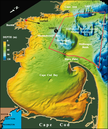
| Figure 1. Perspective map of Massachusetts Bay and Cape Cod Bay illustrating the complex underwater topography. The region is approximately 100 km long and 40 km wide. Stellwagen Bank rises to within about 20 m of the sea surface and partially isolates Massachusetts Bay from the Gulf of Maine. Beginning in 1998, the discharge of treated sewage effluent from the Boston metropolitan area will be relocated from Boston Harbor to a new site 15 km offshore (approximately 35-m water depth) in Massachusetts Bay. The location of the Deer Island Treatment Plant (red dot), the future outfall, the Massachusetts Bay disposal site (MBDS), and the Stellwagen Bank National Marine Sanctuary (SBNMS) are also shown. Note that the MBDS is located outside the SBNMS. Vertical exaggeration is 100X. |
 |