

|
|
|
|
|
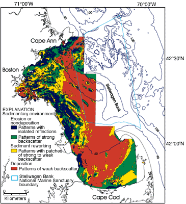
| Figure 3. Distribution of sedimentary environments in the Boston Harbor-Massachusetts Bay sedimentary system. The map shows areas of sediment deposition (typically fine-grained muddy sands and mud in red), two areas characteristic of sediment erosion or non-deposition (areas of boulders or bedrock in blue; areas of gravel and medium to coarse sand in green), and areas of sediment reworking (typically patches of gravelly sand, sand, and mud in yellow). (See Knebel and Circe,1995; Knebel and others, 1996.) |
 |