

|
|
|
|
|
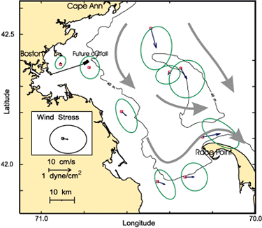
| Figure 5. Observed mean flow (small blue arrows) and the variability (shown as a green ellipse centered around the tip of the mean flow arrows) for near-surface currents (4-8 m below sea surface) measured between December 1989 and September 1991. Typically, the daily-averaged current originates at the station symbol (red squares) and flows toward any location within the ellipse. In general, the fluctuations are larger than the mean. The bold gray arrows indicate the overall direction of the residual drift. The mean wind during this period was from the west at about 0.1 dyne/cm2 as measured at the Boston buoy. (See Geyer and others, 1992.) |
 |