

|
|
|
|
|
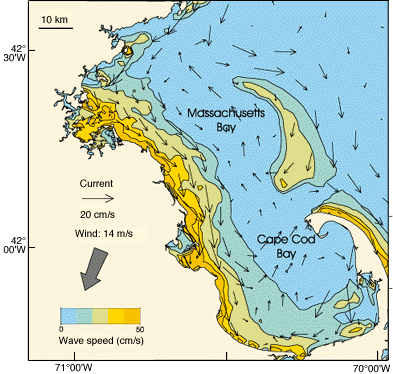
| Figure 9. Modeled wind-induced currents (arrows) and contours of near-bottom wave current speed driven by a northeasterly wind of 14 m/s (28 knots). Near-bottom wave speeds in excess of about 10 cm/s are sufficient to resuspend fine-grained sediments. During major northeasters, fine sediments along the western shore of Massachusetts Bay are resuspended by the wave currents and transported by the wind-driven flow to the southeast toward Cape Cod Bay, where they settle. They are protected from the influence of subsequent storms by water depth and basin geometry. The numerical circulation models provide predictions of the basinwide storm response, which would be very difficult to observe directly. |
 |