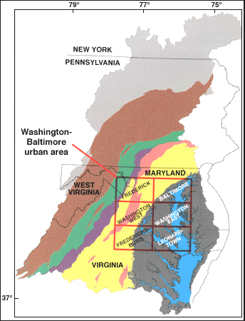
The U.S. Geological Survey (USGS) Geology of the Mid-Atlantic Corridor (GOMAC) project, under the National Cooperative Geologic Mapping Program, conducts geologic mapping and related investigations in the urban corridor extending from Virginia to New Jersey. Project efforts are directed to complete 1:100,000-scale geologic mapping of the Washington-Baltimore urban area (figs. 1 and 2), to complete geologic maps of New Jersey in cooperation with the New Jersey Geological Survey, to complete geologic mapping in progress in cooperation with the Maryland Geological Survey and Virginia Division of Mineral Resources, to investigate and interpret the regional geology as a foundation for numerous applications, and to work with other agencies and customers to identify useful information products that can be derived from the geologic mapping.
|
|
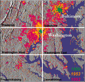
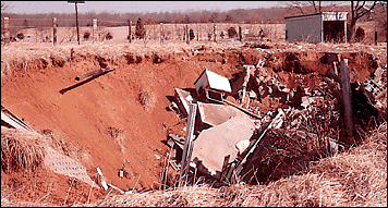
The Mid-Atlantic urban corridor is one of the largest and most complex urban areas in the United States. This area of rapidly growing and coalescing cities and towns has sustained three centuries of urban growth. Spatial geologic information about this region is needed to address problems such as those related to the quality and quantity of ground water and surface water; supplies of natural aggregate and industrial minerals (fig. 3); waste disposal (fig. 4); protection of coastal, wetland, and Piedmont environments; and preparation for hazards such as flooding, sinkholes (fig. 5), and slope failure. GOMAC is designed to provide basic geologic information that is relevant to these problems and to contribute to the National Geologic Map Database.
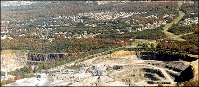
Figure 3. Quarry in Northern Virginia. Geologic maps are used in planning to sustain local supplies of crushed stone. Depending on distance, costs of transportation can exceed those of materials, thus affecting public and private construction costs and local costs of living. |
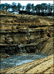
Figure 4. Commercial solid-waste disposal facility in the Patuxent River valley. Understanding the geology of Coastal Plain deposits in this area helped locate clay beds forming the impermeable boundary at the botttom of the pit. Photo by W.L. Newell. |
|
Figure 5. Collapsed home in sinkhole on Ordovician limestone in the Shenandoah Valley exemplifies karst hazards associated with carbonate rocks such as limestone, dolomite, and marble in areas of the Piedmont, Great Valley, and Valley and Ridge. Photo by R.C. Orndorff. |
GOMAC is responding in several ways to the needs identified by the user community. For example, supplementary layers of information are being added where possible to make geologic maps more useful for special applications. Efforts to standardize terminology and map formats are being encouraged. Regional 1:100,000-scale geologic maps for media such as CD-ROM's and World Wide Web sites are being explored to disseminate information more rapidly. User-friendly formats that can be used to generate customized maps are under consideration. Partners and cooperators are being actively sought in all of these efforts.
|
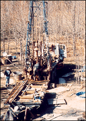
Figure 6. USGS drilling crew helping U.S. Army Corps of Engineers develop a hydrogeologic framework for ground-water modeling at a weapons-disposal Superfund site on the Aberdeen Proving Ground in the Coastal Plain near Chesapeake Bay (Powars, 1997). Geologic mapping includes subsurface as well as surface information. Photo by D.S. Powars. |
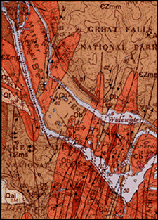
In accord with interagency agreements with the Virginia Division of Mineral Resources, collaborative 1:100,000-scale geologic maps are being completed for the Appomattox, Va., and South Boston, Va.-N.C., 30'x60' quadrangles. The GOMAC project continues to produce 1:24,000-scale geologic maps (fig. 7) in response to the strong demand for detailed information in areas of urban and suburban growth. The quality and accuracy of 1:100,000-scale geologic maps are strongest where these compilations are supported by more detailed mapping and related investigations. Special-purpose maps derived from the basic geologic maps include lithogeochemical maps of the Chesapeake Bay watershed for the USGS Fragile Environments Program and maps delineating potential sources of aggregate for the USGS Mineral Resource Surveys Program.
|
Figure 7. Image of map showing geology of the Great Falls National Park area, Falls Church 7.5-minute quadrangle, Virginia and Maryland (Drake and Froelich, 1997). |
Drake, A.A., Jr., and Froelich, A.J., 1997, Geologic map of the Falls Church quadrangle, Fairfax and Arlington Counties and the City of Falls Church, Virginia, and Montgomery County, Maryland: U.S. Geological Survey Map GQ-1734, scale 1:24,000.
Drake, A.A., Jr., Volkert, R.A., Monteverde, D.H., Herman, G.C., Houghton, H.F., Parker, R.A., and Dalton, R.F., 1996, Bedrock geologic map of northern New Jersey: U.S. Geological Survey Miscellaneous Investigations Series Map I-2540-A, scale 1:100,000, 2 sheets.
Froelich, A.J., Garnass, A.D., and Van Driel, J.N., 1978, Applications in an Atlantic Coast Environment-II, Franconia area, Fairfax County, Virginia; Planning a new community in an urban setting: Lehigh, in Robinson, G.D., and Spieker, A.M., eds., "Nature to be commanded...": U.S. Geological Survey Professional Paper 950, p. 69-89.
Gundersen, L.C.S., Reimer, G.M., Wiggs, C.R., and Rice, C.A., 1988, Map showing radon potential of rocks and soils in Montgomery County, Maryland: U.S. Geological Survey Miscellaneous Field Studies Map MF-2043, scale 1:62,500.
Horton, J.W., Jr., and Cleaves, E.T., eds., 1997, Forum on Geologic Mapping Applications in the Washington-Baltimore Urban Area: U.S. Geological Survey Circular 1148, 46 p.
Langland, M.J., Lietman, P.L., and Hoffman, S., 1995, Synthesis of nutrient and sediment data for watersheds within the Chesapeake Bay drainage basin: U.S. Geological Survey Water Resources Investigations Report 95-4233,121 p.
McCartan, Lucy, Newell, W.L., Owens, J.P., and Bradford, G.M., 1995, Geologic map and cross sections of the Leonardtown 30 x 60-minute quadrangle, Maryland and Virginia: U.S. Geological Survey Open-File Report 95-665, scale 1:100,000.
Mixon, R.B., Pavlides, L., Powars, D.S., Froelich, A.J., Weems, R.E., Schindler, J.S., Newell, W.L., Edwards, L.E., and Ward, L.W., in press, Geologic map of the Fredericksburg 30' x 60' quadrangle, Virginia and Maryland: U.S. Geological Survey Miscellaneous Investigations Series Map I-2607, scale 1:100,000, 2 sheets.
Obermeier, S.F., ed., 1984, Engineering geology and design of slopes for Cretaceous Potomac deposits in Fairfax County, Virginia, and vicinity: U.S. Geological Survey Bulletin 1556, 88 p.
Obermeier, S.F., and Langer, W.H., 1986, Relationships between geology and engineering characteristics of soils and weathered rocks of Fairfax County and vicinity, Virginia: U.S. Geological Survey Professional Paper 1344, 30 p.
Orndorff, R.C., and Goggin, K.E., 1994, Sinkholes and karst-related features of the Shenandoah Valley in the Winchester 30' x 60' quadrangle, Virginia and West Virginia: U.S. Geological Survey Miscellaneous Field Studies Map MF-2262, scale 1:100,000.
Powars, D.S., 1997, Stratigraphy and geophysical logs from a corehole drilled to bedrock at Robins Point, J-Field, Edgewood Area, Aberdeen Proving Ground, Maryland: U.S. Geological Survey Open-File Report 97-357, 68 p.
Pomeroy, J.S., 1988, Map showing landslide susceptibility in Maryland: U.S. Geological Survey Miscellaneous Field Studies Map MF-2048, scale 1:500,000.
| - J. Wright Horton, Jr. |
Wright Horton
|
U.S. Department of the Interior U.S. Geological Survey |
March 1998 USGS Fact Sheet FS 184-97 |
This page is URL https://pubs.usgs.gov/factsheet/fs184-97/
Last modified 4 March 1999
Maintained by Kathie Watson