

|
|
|
|
|
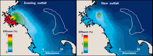
| Figure 2. Model comparison of winter near-surface (2-m depth) effluent concentrations at the existing sewage outfalls and at the new outfall. The red line indicates a concentration of 0.5 percent (200-fold dilution of effluent), which is approximately the level at which nutrient levels released in the effluent are comparable to background variability. With the existing outfall locations, high effluent concentrations are found within Boston Harbor and along the coastline immediately south. With the new outfall location, high concentrations are found only within a few kilometers of the outfall, concentrations are dramatically lower in Boston Harbor, and concentrations in most of Massachusetts Bay (including the region near Stellwagen Bank) are not significantly changed from their existing low levels. The white outline indicates the location of Stellwagen Bank. |
 |