
|
|
|
|
|
Bolide Impact
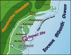
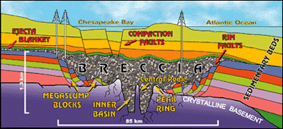
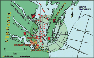
The entire bolide event, from initial impact to the termination of breccia deposition, lasted only a few hours or days. The crater was then buried by additional sedimentary beds, which accumulated during the following 35 million years. Bolide CraterThe Chesapeake Bay crater was recently identified by C. Wylie Poag (U.S. Geological Survey, USGS), who has assembled an international team to investigate its characteristics and consequences. Evidence of the crater comes from two sources: (1) cores drilled by the USGS and the Virginia State Water Control Board (fig. 2), and (2) marine seismic-reflection profiles collected by Texaco, Inc., the USGS, and the National Geographic Society.
The cores sampled a sandy rubble bed, which contains hand-size to person-size chunks (clasts) of clay, limestone, and sand. The clasts change rapidly downcore in composition, size, color, orientation, and age. The clasts are fragments ripped from previously deposited beds that underlie southeastern Virginia. Small pieces of the deeply buried granitic basement rocks also are scattered throughout the rubble and contain shocked quartz and melted grains, which confirm an impact. The structure and geometry of the crater were determined by seismic profiling from ships in the bay. Seismic profiles are like two-dimensional cross sections of the subsurface beds. Analysis of 1,200 km of profiles shows that the crater is 85 km in diameter and 1.3 km deep; an excavation twice the size of Rhode Island and as deep as the Grand Canyon. It is three times larger than any other U.S. crater and is the sixth largest crater known on the planet. The rubble bed, which we now realize is an impact breccia, fills the crater and forms a thin halo around it, called an ejecta blanket. Effects of the Bolide ImpactDiscovery of the giant crater has completely revised our understanding of Atlantic Coastal Plain evolution. In particular, studies by Poag's project revealed several consequences of the ancient cataclysm that still affect citizens around the bay today: land subsidence, river diversion, disruption of coastal aquifers, ground instability, and location of Chesapeake Bay. These are discussed below.Land SubsidenceEvidence of accelerated land subsidence is reflected in the geology and topography of the modern land surfaces around the crater. The breccia is 1.3 km thick and was deposited as a water-saturated, sandy, rubble-bearing slurry (like concrete before it hardens). The sediment layers surrounding the crater, on the other hand, were already partly consolidated, and so the mushy breccia compacted much more rapidly under its subsequent sediment load than the surrounding strata. The compaction differences produced a subsidence differential, causing the land surface over the breccia to remain lower than the land surface over sediments outside the crater. Poag's team observed that the boundary between older surface rocks and younger surface rocks coincides with the position and orientation of the crater rim on all three peninsulas that cross the rim. The older beds have sagged over the subsiding breccia, and the younger rocks have been deposited in the resulting topographic depression. The topography also reflects the differential subsidence. The Suffolk Scarp and the Ames Ridge are elevated landforms (10-15 meters high) located at, and oriented parallel to, the crater rim. Crater-related ground subsidence also may play a role in the high rate of relative sea-level rise documented for the Chesapeake Bay region. One of the locations of highest relative sea-level rise is at Hampton Roads (the lower part of the James River), located over the crater rim. River DiversionEven the courses of the modern rivers in the lower bay region point to the continued influence of differential subsidence over the crater. Most of the rivers, like the Rappahannock, flow southeastward to the Atlantic. In contrast, the York and James Rivers make sharp turns to the northeast near the outer rim of the crater. Disrupted Coastal AquifersAnother consequence of the bolide is that all ground-water aquifers were truncated and excavated by the impact. In place of those aquifers, there is now a single huge reservoir with a volume of 4,000 cubic kilometers. That's enough breccia to cover all of Virginia and Maryland with a layer 30 m thick. In this huge new reservoir, pore spaces are filled with briny water that is 1.5 times saltier than normal seawater. This water is too salty to drink or to use in industry. Geohydrologists have known of this salty water for decades, but only now are we beginning to grasp the true nature of its origin and distribution. The presence of this hypersaline aquifer has some practical implications for ground-water management in the lower bay region. For example, we need to know how deeply buried the breccia is in order to avoid drilling into it inadvertently and contaminating the overlying freshwater aquifers. Its presence also limits the availability of freshwater. On the Delmarva Peninsula, over the deepest part of the crater, only the aquifers above the breccia are available for freshwater. The crater investigation shows that we need to be especially conservative of ground-water use in that area. Ground Instability Due To FaultingSeismic profiles across the crater show many faults that cut the sedimentary beds above the breccia and extend upward toward the bay floor (fig. 3). The resolution of our seismic profiles allows us to trace the faults to within 10 m of the bay floor. These faults are another result of the subsidence of the breccia. These faults are zones of crustal weakness and have the potential for continued slow movement, or sudden larger offsets if reactivated by earthquakes.
Some of the faults appear to completely breach the confining unit over the saltwater reservoir. They could allow the salty water to flow upward and contaminate the freshwater supply. Poag is mapping the location, orientation, and amount of offset of these compaction faults. Location of Chesapeake BayDid the Chesapeake Bay bolide affect the location of Chesapeake Bay itself? We know that the bay is nowhere near 35 million years old. In fact, as late as 18,000 years ago, the bay region was dry land; the last great ice sheet was at its maximum over North America, and sea level was about 200 m lower than at present. This sea level exposed the area that now is the bay bottom and continental shelf. With sea level this low, the major east coast rivers had to cut narrow valleys across the region all the way to the shelf edge. About 10,000 years ago, however, the ice sheets began to melt rapidly, causing sea level to rise and flood the shelf and the coastal river valleys. The flooded valleys became the major modern estuaries, like Delaware Bay and Chesapeake Bay. The rivers of the Chesapeake region converged at a location directly over the buried crater. In short, the impact crater created a long-lasting topographic depression, which helped determine the eventual location of Chesapeake Bay.
Metric Units Explained1 kilometer (km) = 0.621 mile1 meter (m) = 3.28 feet 4,000 cubic kilometers = 960 cubic miles
|
Related Publication:
The Chesapeake Bay: Geologic Product of Rising Sea Level - USGS Fact Sheet 102-98 Related Links: Earth Impact Database National Aeronautics and Space Administration |