
Science for Ecosystem Restoration: The Place-Based Studies Program
The USGS Place-Based Studies (PBS) Program provides objective integrated science for managers who are seeking to restore natural functions and values of resources and the environment. In order to restore these functions, managers must have scientific information to resolve the complex resource problems that are before them. Resource managers use scientific information for several purposes. First, it helps to define the extent of environmental problems, and to distinguish changes caused by management actions from natural changes caused by climatic shifts, environmental succession, and natural climatic variability. Second, understanding how the ecosystem functions helps managers formulate possible solutions to those problems. Third, ecosystem models provide tools for determining which proposed actions will be the most effective in resolving the problems. Fourth, scientific information is necessary to develop the criteria and strategy for monitoring the success of management modifications.
Goals
The goals of the PBS Program are (1)
to provide relevant, high-quality, impartial scientific information that permits resource-management agencies to improve the scientific basis for their
decisions and to prevent or resolve resource-management conflicts and
(2) to facilitate integration of scientific information.
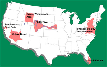
The PBS Program integrates USGS research in specific, critical ecosystems. At present the areas under study are the San Francisco Bay/Delta, South Florida, the Chesapeake Bay, the Platte River, the Greater Yellowstone area, the Mojave Desert, and the Salton Sea (fig. 1). Funding has been requested to start studies in the Great Lakes in FY 2000 .
|
Figure 1. Study areas in the Place-Based Studies Program.
|
The information is designed to have a direct, significant, and immediate impact on management and policy decisions. Multi- and inter-disciplinary approaches to environmental science are used to address issues that involve environmental resources such as water, minerals, biota, and land in specific critical ecosystems in the United States.
Scientist are selected for their particular expertise from the wide array of disciplines within the USGS, and apply their diverse approaches to common problems. Studies in the present suite of ecosystem areas include land characterization, surface hydrologic and ecological modeling, geospatial database management, ground- and surface-water hydrology, geophysics, ecology, geochemistry, paleontology, and contaminant, sediment, and nutrient dynamics. Scientists improve their
interpretation of data by working with related information from other disciplines.
South Florida
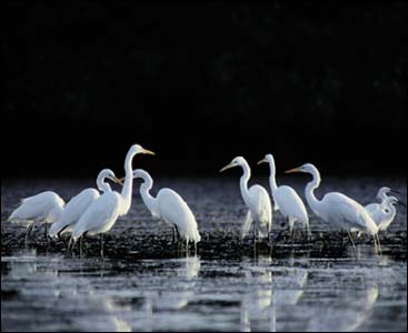
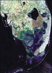
Diversions of water and excessive nutrients and mercury within the Everglades have devastated bird populations and driven many species to the brink of extinction (fig. 2). In Florida Bay, declines in seagrasses which hold sediment in place and provide habitat for fish result in decreasing water clarity and declining fish populations. The U.S. Army Corps of Engineers (Corps), the South Florida Water Management District (SFWMD), and other stakeholders are drawing up plans for restoring the Everglades and Florida Bay. USGS information and models help the Corps, the National Park Service, Florida Department of Environmental Protection (FDEP), the U.S. Environmental Protection Agency (EPA), the U.S. Fish and Wildlife Service (FWS) and the SFWMD predict the consequences of varied management alternatives, set ecological goals by providing yardsticks to measure the success of the restoration, and manage the natural resources of the system. In FY 1999 the primary task of the USGS scientific program in South Florida will shift from primary data collection and research activities to enhancement of electronic availability of scientific information, and integration and synthesis of the scientific information that has been developed. The synthesis will integrate the accumulated scientific knowledge and understanding from USGS studies, help to chart the future scientific direction of the USGS program, and contribute to interagency synthesis activities to assist decisionmaking for restoration of South Floridaąs ecosystem (fig. 3).
|
|
|
Figure 2. Everglades bird populations, like the great egret, have been negatively impacted by diversions of water.
|
Figure 3. Satellite image showing the South Florida ecosystem study area.
|
In the Everglades and Florida Bay, the USGS provides a broad suite of information and computer models to its clients and partners through the South Florida Ecosystem Restoration Task Force and associated work groups. USGS hydrologic models, monitoring data, and ecosystem history results are used by the Corps and SFWMD for detailed planning. USGS seepage models and data help to predict
the potential for flooding of urban areas due to cutting through levees to protect an endangered species population. Flows and water quality information collected by the USGS will be used to help develop water quality standards required before FY 2002 and monitor water flowing through land of the Miccosukee and Seminole tribes. USGS mercury information will be used to develop a mercury monitoring plan by the SFWMD in FY 1999. USGS monitoring information and biological response models will be used by the Corps in a circulation model to estimate changes resulting from restoration, and by the National Oceanic and Atmospheric Administration to manage the Marine Sanctuary in Florida Bay. Communities in the Florida Keys use USGS information on nutrient see page into coral reefs to determine whether to modify their sewage-disposal practices. USGS information on Florida Bay is also used to refine the Stateąs environmental monitoring programs and to improve the understanding of sediment resuspension and seagrass community changes. USGS hydrologic and geologic baseline information also helps determine water supply potential for increasing populations on the west and east coasts, and potential effects of reductions of water flow into Biscayne Bay National Park.
San Francisco Bay and Delta
Declines in populations of fish and wildlife in San Francisco Bay estuary result from destruction of wetland habitats, diversion of freshwater for irrigation and drinking water, introduction of exotic species, and contamination from urban, agricultural, and industrial sources. Studies on wetland processes operating in saltmarsh ecosystems focus on relations between proposed changes in the physical habitat of rehabilitated wetlands and the biological responses of fish species, shorebirds, and migratory waterfowl in those wetlands. Other studies have focused on relations between water flow, pesticide and metals concentrations, sediment concentrations and transport, and salinity distributions; and the effects of these factors and their interrelations on fish and avian populations in the Bay.
The USGS program in San Francisco Bay is planned and extensively coordinated with our partners within the CALFED Community. CALFED cooperators include the California Agencies (Departments of Water Resources and Fish and Game, State-EPA, and State Water Resources Control Board), Federal Agencies (the USEPA, the FWS, Bureau of Reclamation, National Marine Fisheries Service, and the Corps of Engineers), and other local environmental management and resource agencies.
Chesapeake Bay
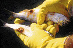
In the Chesapeake Bay, the Nationąs largest estuary, excessive nitrogen and phosphorus have caused periods of hypoxia (insufficient dissolved oxygen to support living resources). The high levels of nutrients and associated sediment loads and algal blooms also decrease water clarity, which is largely responsible for the decline in submerged aquatic vegetation (SAV). SAV is one of the most important components of the ecosystem because it provides an essential habitat for shellfish and fin fish and food for waterfowl. In 1987, the EPA Chesapeake Bay Program established a nutrient-reduction goal designed to reduce nutrient loads into the estuary by 40 percent by the year 2000, in hopes of eliminating hypoxia in the mainstem of the Bay and encouraging the regrowth of SAV. More recently, fish die-offs from algal blooms (Pfeisteria) have spurred managers to implement additional nutrient control measures (fig. 4).
|
Figure 4. The incidence of fish health problems, ranging from small external sores and lesions to large-scale fish-kills, is a growing problem in the Chesapeake Bay. Fish kills have been reported in the Chesapeake Bay watershed in the past two years.
|
Scientific information from the USGS Chesapeake Bay Program, begun in 1996, is used by our Federal and State partners in the Chesapeake Bay Program to assess water quality and living resource response to changes in nutrients and climate variability. USGS data on SAV and nutrients in ground- and surface-water will help managers determine if the nutrient goal for the year 2000 has been met and can be maintained as a cap beyond 2000. Scientific information has helped improve agricultural and land management strategies for reducing nutrients from tributaries by identifying areas of high nutrient loads and predicting the lag time between changes in nutrient management practices and improvements in water quality. In addition, the historical context provided by USGS information on nutrient variability and response to changes in inputs through time allows managers to better evaluate the feasibility of attaining nutrient goals. USGS is designing a decision support system that includes land and estuarine spatial coverages and current environmental and land use conditions at different spatial scales. USGS information on nutrients, historical algal populations, and analyses of the causes of fish mortality that occurred in 1997 promotes better understanding of the historical prevalence, environmental causes, and management solutions for preventing these serious
outbreaks.
Greater Yellowstone Area
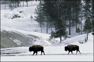
The Greater Yellowstone Ecosystem contains natural phenomena that are unique on our continent‹migrating herds of wildlife, indigenous predators, and geothermal features associated with one of the largest dormant volcanic areas in North America. An ever-increasing number of people live and vacation in this landscape, which is administered by a medley of agencies that have distinct
policies and objectives. The natural system that operates here does not respect administrative boundaries; contradictory management objectives can result in contentious consequences. This was
illustrated during the winter migration of bison in 1997, which reduced the herd by one-half (fig. 5). Numerous bison were killed when they left Yellowstone National Park and entered state and
private lands in Montana because of a concern that introductions of the disease into cattle herds could severely damage the Stateąs agricultural economy. A fraction of those bison carry brucellosis, a disease that causes spontaneous fetal abortions in cattle.
|
Figure 5. During the winter migration of bison in 1997, the herd was reduced by one-half. Numerous bison were killed when they left Yellowstone and entered state and private lands
in Montana.
|
|
The lack of consistent geographic information that spans administrative boundaries hampers objective evaluation of the cattle-brucellosis-bison situation, as well as many other resource utilization questions. The goal of the Greater Yellowstone Ecosystem Initative is to create an integrated data management system that can be used to understand, predict, and manage wildlife/human interactions. The Initiative is developing a geographic information template of landscape attributes such as geology, topography, vegetation, climate, and hydrology, and parallel information on the use of the landscape by wildlife and people. By developing and sharing data resources with NPS, U.S. Forest Service, and State partners, information will be consistent across ownership and management unit boundaries. This information will be in a form that can be applied to management decisions concerning wildlife and its habitat,
geothermal and mineral resources, and natural hazards.
Mojave Desert
Human activities, such as grazing
animals, off-highway vehicle use, construction, mining, urban expansion, waste disposal, recreational uses, water withdrawal, and natural processes influenced by man such as fire and invasion of non-native species, have increased the vulnerability of the desert environment to soil erosion and habitat degradation (fig. 6). USGS integrates multiple sources of scientific information to assess environmental vulnerability and recoverability. USGS works closely with the California Desert Managers Group, other land management agencies, and groups in the Mojave Desert to identify the data, interpretations, information format, and predictive tools they need. The program combines baseline data management with process studies and extrapolates the results of surface investigations to make regional assessments. The ultimate goal in the Mojave is to create a decision support system that (1) describes the vulnerability of the land to erosion, invasion by noxious weeds, climatic variability, and other disturbances, (2) identifies emerging patterns of resource use, and (3) determines the potential for recovery of degraded land so managers can better target their activities.
|
Figure 6. The Mojave Desert Ecosystem Science Program investigates the vulnerability and recoverability of the desert environment.
|
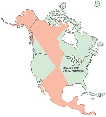
Figure 7. Spring migration corridor, Central Flyway, Great Plains.
|
Platte River
The Platte River is an internationally significant staging area for migratory water birds of the Central Flyway and is a critical habitat for the whooping crane (fig. 7). Major reservoirs and water diversion projects, which are critically important to the areaąs economic base, have transformed the landscape, changed the river channel, and altered adjacent wet meadows. In July 1997, the Department of the Interior and the states of Wyoming, Colorado, and Nebraska signed a Memorandum of Agreement to develop and implement a recovery program for target species in the Central Platte. The goals of the USGS study are to support the information needs of the Memorandum by increasing access to information and to provide integrated information on the Platte River ecology, historical landforms, and surface and groundwater hydrology. Quantitative studies on fluvial geomorphology and biological system health focus on relations between river hydraulics, sediment transport, vegetation, migratory bird habitat, and avian health. Understanding these relationships is critical for prediction of the effects of water and vegetation management on avian and fish species.
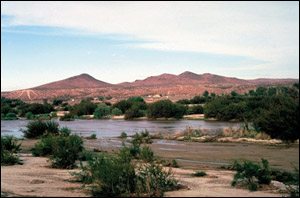
Salton Sea
The Salton Sea Basin is a highly productive ecosystem, with tremendous importance to the migration, wintering, and breeding of many water birds in the Pacific Flyway . The decline of wetlands in the western flyway during this century makes the Salton Sea much more crucial for many birds. Since the Seaąs accidental formation early in this century, salinity and nutrient levels have increased dramatically because, as a terminal lake, incoming irrigation drainwater evaporates in the intense heat of the desert. Although the Salton Sea continues to be important for wildlife, wildlife diseases appear to be increasing, and the economic and recreational benefits from hunting, fishing and tourism have declined. Stakeholders are exploring options for restoration to economic and environmental productivity, but they need better information on factors contributing to system decline and fish and wildlife diseases. The program will focus, at least initially, on disease issues as they relate to the Salton Sea
system.
Project descriptions, plans, and information generated by the program are available on the World Wide Web:
|
For more information, please contact:
|
Sarah Gerould
Place-Based Studies Program Coordinator
U.S. Geological Survey
906 National Center
Reston, VA 20192
Telephone: (703) 6486895
E-mail: sgerould@usgs.gov
|
U.S. Department of the Interior
U.S. Geological Survey
|
|
|
|
|
|
|
|
|
|
|
|
|
|
|
|
|
|
|
|
|
|
|
|
|
|
USGS Fact Sheet FS-070-98
Revised June 1999
|
This page is https://pubs.usgs.gov/factsheet/fs70-98/
Maintained by Eastern Publications Group Web Team
Last revised 7-19-99