|
|
|
|
|
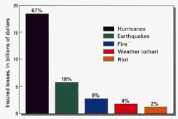
During August and September 1992, Category 4 hurricanes, with sustained winds between 131 mph and 155 mph, made four landfalls in the United States and its territories. The resulting damage in south Florida, Louisiana, Guam, and Hawaii was in the tens of billions of dollars. Hurricanes and extreme extratropical storms cause elevated sea level, known as storm surge, and extensive shoreline erosion and other geologic effects leading to the loss of property and life. We cannot yet predict with confidence the magnitude of this erosion and the extent of geologic impacts. The variability of shoreline types, including barrier islands of Louisiana, mangroves of south Florida, coral reefs and pocket beaches of Hawaii and Guam, make predictions especially difficult.
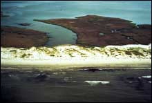
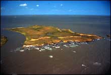
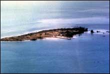
Rapid-response surveys of Hurricane Andrew's impact zone conducted by the USGS reveal surprising results.For Hurricane Andrew, the loss of human life and property is well documented. However, the environmental effects are less well-known. In south Florida, Hurricane Andrew completely stripped vegetation from the northernmost Florida Keys. In the case of mangrove trees, defoliation and wood damage killed large old stands along the shoreline. Area studies reveal the immense change brought about by these storms.In Louisiana, Dr. Shea Penland and his colleagues at the LGS reported that Andrew stripped sand from 70 percent of the barrier islands leaving exposed old coastal marsh. More than 80 percent of oyster reefs behind the barrier islands were smothered by a 0.3-0.9-meter thick blanket of sediment. More than 70 kilometers of valuable dune habitat providing storm protection to estuaries, wetlands, and the coastal population were destroyed. In Hawaii, Dr. Charles Fletcher and his colleagues at the University of Hawaii cooperated with USGS scientists in a study of the effects of Hurricane Iniki, the most powerful hurricane to strike the Hawaiian Islands this century. They report that Iniki caused massive beach-face erosion and overwash of the coastline which penetrated up to 300 meters reaching elevations of nearly 9 meters.
USGS scientists have used historical data to show that Louisiana is eroding rapidly.The Louisiana barrier island shoreline is eroding at a rate, in some places, exceeding 20 meters per year as a result of both hurricanes and normal processes. The land is subsiding because of compaction of the Mississippi delta sediments. The net effect of subsidence is that sea level is rising at a rate of about 1 centimeter per year, ten times the world rate. USGS scientists take advantage of this natural laboratory to study erosion and deposition patterns resulting from sea-level change. The Louisiana barrier islands protect productive estuarine and wetland environments that support a $10 billion per year fishing industry. Erosion of the barrier islands is so severe that their ability to function as effective buffers for the prevention of wetlands loss has been dramatically reduced. Louisiana's wetlands are disappearing at rates of 40 square kilometers per year. In a few decades the barrier islands may be gone and the wetlands will be lost even faster.
Information collected by USGS scientists aids coastal planners and managers.Information and expertise gained during the Louisiana Barrier Island Erosion Study has had a direct impact on local plans for mitigating barrier island loss. Data on seafloor change, shoreline change, and geologic framework have been provided to parish planners and engineers involved in restoration projects. USGS scientists cooperate with State and local governments to provide technical advice on use of sand resources for barrier island nourishment.
USGS scientists plan studies of the high-energy processes responsible for storm damage.In order to help mitigate the impacts caused by hurricanes such as Andrew and Iniki, environmental managers and engineers must understand the geological processes that cause erosion and environmental change. Results of the recently-completed Louisiana Barrier Island Erosion Study are presently used in formulating erosion-mitigation strategies. Documentation of impacts by Andrew to this area, for example, when compared and interpreted in relation to previously-gathered data, provide an invaluable baseline for mitigation projects and loss-reduction strategies for other areas affected by such storms.
|
Related Links: Louisiana Geological Survey Mapping Coastal Change Hazards Tropical Storm Tracks University of Hawaii National Oceanic and Atmospheric Administration National Hurricane Center |
|||||||||||||||||||||||||||||||||||||||||||||||||||||||||||||||||||||||||||