
|
|
|
|
|
Louisiana's 3 million acres of wetlands are lost at the rate about 75 square kilometers annually, but reducing these losses is proving to be difficult and costly.
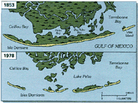
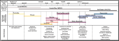
U.S. Geological Survey (USGS) scientists have undertaken cooperative studies with several Federal and State agencies to study the Louisiana coast.USGS has undertaken joint field investigations with Federal, State, and university partners to gather and interpret baseline information for improving scientific understanding of the critical processes responsible for creation, maintenance, and deterioration of coastal wetlands. In 1988, USGS scientists began a study of wetland processes in cooperation with the U.S. Fish and Wildlife Service and the Louisiana State University as an extension of the recently-completed Louisiana Barrier Island Erosion Study. Large data sets on topics such as storm effects, movement of water and dispersal of fine-grained sediments, soil development, marsh disintegration, and effects of land subsidence and sea-level rise have been systematically collected since 1989 from representative sediment-starved and sediment-rich basins in Louisiana. Synthesis and comparisons of these data sets enhance our knowledge of how wetlands function and the critical processes responsible for change. USGS and other studies indicate that major shifts in the course of the Mississippi River have contributed significantly to the demise of the wetlands.The 300 kilometer-wide Mississippi River delta plain and its associated wetlands and barrier shorelines are the product of the continuous accumulation of sediments deposited by the river and its distributaries during the past 7,000 years. Regular shifts in the river's course have resulted in four ancestral and two active delta lobes, which accumulated as overlapping, stacked sequences of unconsolidated sands and muds. As each delta lobe was abandoned by the river, its main source of sediment, the deltas experienced erosion and degradation due to compaction of loose sediment, rise in relative sea level, and catastrophic storms. Marine coastal processes eroded and reworked the seaward margins of the deltas forming sandy headlands and barrier beaches. As erosion and degradation continued, segmented low-relief barrier islands formed and eventually were separated from the mainland by shallow bays and lagoons.The environmental and economic consequences of coastal erosion in Louisiana are significant.Barrier islands fronting the Mississippi River delta plain act as a buffer to reduce the effects of ocean waves and currents on associated estuaries and wetlands. Louisiana's barrier islands are eroding, however, at a rate of up to 20 meters per year; so fast that, according to recent USGS estimates, several will disappear by the end of the century. As the barrier islands disintegrate, the vast system of sheltered wetlands along Louisiana's delta plains are exposed to the full force and effects of open marine processes such as wave action, salinity intrusion, storm surge, tidal currents, and sediment transport that combine to accelerate wetlands deterioration.Human activities during the past century have drastically affected the wetlands.
Methods to mitigate wetlands loss are costly and politically sensitive, affecting communities, agriculture, and industry.A variety of ideas have been put forward as partial solutions to the dramatic loss of barrier islands and wetlands along the Louisiana coast. Most ideas include soft engineering solutions such as coastal restoration through barrier island renourishment. Dredged materials could be distributed onto wetlands. Other ideas include a strategic retreat by creating new navigation channels allowing the delta plains, such as the modern Mississippi River Delta, to erode and proceed through their normal cycles. Such solutions could affect small communities, agricultural interests, and the petroleum industry. Hard engineering solutions, such as building sea walls and breakwaters, are also possible; however, these solutions are not only expensive but have produced mixed results at best.
Consensus on deciding the most cost-effective solutions to wetlands loss should be based on a thorough understanding of the geologic framework and physical processes that drive the barrier island-wetland system.Many questions remain about the environment in which barrier islands evolve and wetland areas evolve and mature. A variety of coordinated studies, such as sediment budget, storm events, wave action, and sea-level fluctuations, are showing how nature intended the barrier island/wetland system to work, and can guide planners to augment the natural evolution of this system rather than operate contrary to nature. Present data collection activities are being included in models that simulate natural processes for future diversions of the Mississippi River, sea-level rise, subsidence of coastal areas, and beach nourishment. Other studies examine ways in which fine-grained sediments can be introduced into wetlands to replace sediments lost by diversion of the river; the aggravating effects of wave action as determined by moving offshore sands to onshore areas; sources of sand for nourishment activities such as sand from Ship Shoal, some 25 kilometers offshore; and whether sediment can best be removed from the ends, the top, or the sides of the shoal. In general, human attempts to engineer coastal areas have had limited success. We still need to reemphasize the lesson from Francis Bacon almost four centuries ago: "Nature to be commanded must be obeyed." Using the latest scientific results of barrier island and wetland studies can help address problems in Louisiana and other coastal regions.
|
Related Publications: Subsurface Controls on Historical Subsidence Rates and Associated Wetland Loss in Southcentral Louisiana
Primary Causes of Wetland Loss at Madison Bay, Terrebonne Parish, Louisiana
- USGS Open File Report 03-060 Environmental Atlas of the Lake Pontchartrain Basin
- USGS Open File Report 02-206 Related Links: U.S. Fish and Wildlife Service Coastal Research Laboratory Louisiana State University |