
|
|
|
|
|
Half a century of dredge spoils disposal has had an unknown effect on the Mamala Bay ecosystem.
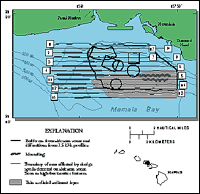
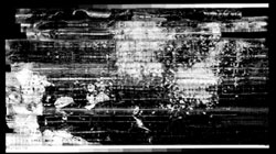
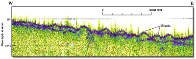
In 1993, the USGS initiated a program sponsored by the USACE and the U.S. Environmental Protection Agency that produced a detailed map of the seafloor, especially of the distribution of dredge spoils, and a preliminary analysis of the environmental effects of dredge-spoils disposal and the chemical effects of the introduction of nutrient-rich outfall. Part of the work would involve sediment sampling, biological testing, and evaluation. Of particular interest is tissue sampling and analysis of endemic shrimp to determine the rates of absorption of toxic elements, such as heavy metals, that are easily brought into the food chain. USGS researchers have compiled a sonar image map of the Mamala Bay seafloor.This map was compiled from sidescan sonar surveys with electronics designed to provide noise-free, shipboard images of maximum resolution. The image map clearly shows the locations of disposed dredge materials as acoustically-bright areas; areas not covered by dredge materials appear acoustically dark. Other interesting seafloor features are large enechelon sand waves or ripples, possibly the result of a disposal technique or military activity.
USGS scientists have described a series of mounds on the sea-floor around dredge spoil disposal sites.The mounds average about 500 feet in diameter and up to 4 feet high, and are thought to be associated with disposal of dredged spoils. Each mound represents about 2,500 cubic yards of sediment, the amount that is contained in a dredge barge. These mounds appear as bright spots on sonar images. USGS researchers explain that the dredging process artificially coarsens the deposits as the suspended fine-grained muds are lost with draining seawater. Those muds included with dredged materials create a plume that lasts over an hour when dumped. USGS studies indicate that such plumes may have significant effects on the health of biological species. USGS researchers will analyze the geologic and biologic distribution of contaminants.
Previous studies provide few definitive results as to the extent of biological uptake of contaminants in the food chain. As a part of the study, USGS scientists, in cooperation with colleagues at the University of Hawaii, will trap bottom-dwelling shrimp to analyze their tissues for toxic element uptake. Fauna in Mamala Bay are directly exposed to sewage outfall from the Honolulu and Pearl Harbor areas, as well as to other non-point sources of contaminants such as from the leaching of soils containing agricultural nutrients and lead paint from shipping activities. In addition, USGS scientists are concerned about the distribution and ultimate fate of sediments to which contaminants are attached. The potential adverse effects from resuspension of contaminants on sediments resulting from continued disposal of dredge spoils are not well known.
|
Related Publications: Sea-Floor Geology of a Part of Mamala Bay, Hawaii Acoustic Mapping of the Regional Seafloor Geology in and Around Hawaiian Ocean Dredged-Material Disposal Sites
- USGS Open File Report 00-124 Final Report: Acoustic Mapping of Dredged Material Disposal Sites and Deposits in Mamala Bay, Honolulu, Hawaii
- USGS Open File Report 95-17 K1-95-HW: Cruise Report 1995 - Preliminary results.
- USGS Open File Report 95-839 Related Links: University of Hawaii U.S. Army Corps of Engineers U.S. Environmental Protection Agency |