
U.S. Geological Survey
Fact Sheet 173-98
U.S.
Geological Survey
Fact Sheet 173-98
| On May 22, 1915, an explosive eruption at Lassen Peak, California, the southernmost active volcano in the Cascade Range, devastated nearby areas and rained volcanic ash as far away as 200 miles to the east. This explosion was the most powerful in a 1914–17 series of eruptions that were the last to occur in the Cascades before the 1980 eruption of Mount St. Helens, Washington. Recent work by scientists with the U.S. Geological Survey (USGS) in cooperation with the National Park Service is shedding new light on these eruptions. |
Lassen Peak is the largest
of a group of more than 30 volcanic domes erupted over the past 300,000 years
in Lassen Volcanic National Park in northern California. These mound-shaped
accumulations of volcanic rock, called lava domes, were created by eruptions
of lava too viscous to flow readily away from its source. Eruptions about 27,000
years ago formed Lassen Peak, probably in only a few years. With a height of
2,000 feet and a volume of half a cubic mile, it is one of the largest lava
domes on Earth. When Lassen Peak formed, it looked much like the nearby 1,100-year-old
Chaos CragsDomes, with steep sides covered with angular rock talus. However,
from 25,000 to 18,000 years ago, during the last ice age, Lassen’s shape
was significantly altered by glacial erosion. For example, the bowl-shaped depression
on the volcano’s northeastern flank, called a cirque, was eroded by a glacier
that extended out 7 miles from the dome.
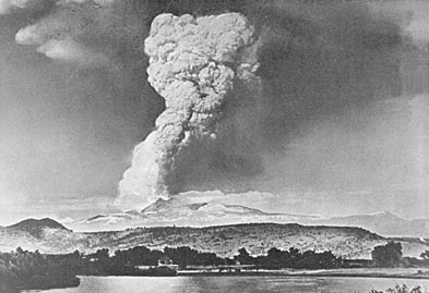 |
| The May 22, 1915, explosive eruption of Lassen Peak, California, blasted rock fragments and pumice high into the air and rained fine volcanic ash as far away as Winnemucca, Nevada, 200 miles to the east. In this photograph taken from near the town of Red Bluff, 40 miles west of the volcano, the huge column of volcanic ash and gas produced by the eruption rises to a height of more than 30,000 feet. (Photograph taken by R.E. Stinson; courtesy of the National Park Service.) |
On May 30, 1914, Lassen
Peak awoke from a 27,000-year-long slumber when it was shaken by a steam explosion.
Such steam blasts occur when molten rock (magma) rises toward the surface of
a volcano and heats shallow ground water. The hot water rises under pressure
through cracks and, on nearing the surface, vaporizes and vents explosively.
By mid-May 1915, more than 180 steam explosions had blasted out a 1,000-foot-wide
crater near the summit of Lassen Peak. Then the character of the eruption changed
dramatically. On the evening of May 14, 1915, incandescent blocks of lava could
be seen bouncing down the flanks of Lassen from as far away as the town of Manton,
20 miles to the west. By the next morning, a growing dome of dacite lava (lava
containing 63 to 68% silica) had welled up into the volcano’s crater and
filled it.
Late on the evening of
May 19, a large steam explosion fragmented the dacite dome, creating a new crater
at the summit of Lassen Peak. No new magma was ejected in this explosion, but
glowing blocks of hot lava from the dome fell on the summit and snow-covered
upper flanks of Lassen Peak. These falling blocks launched a half-mile-wide
avalanche of snow and volcanic rock that roared 4 miles down the volcano’s
steep northeast flank and over a low ridge at Emigrant Pass into Hat Creek.
As the hot lava blocks broke
into smaller fragments, the snow melted, generating a mudflow of volcanic materials,
called a lahar. The bulk of this lahar was deflected northwestward at Emigrant
Pass and flowed 7 miles down Lost Creek. Even after coming to rest, both the
avalanche and lahar released huge volumes of water,
flooding the lower Hat Creek Valley during the early morning hours of May 20.
The lahar and flood destroyed six mostly not-yet-occupied summer ranch houses.
Fortunately, the few people in these houses escaped with only minor injuries.
Also during the night of May19–20, dacite lava somewhat more fluid than that erupted on the night of May 14–15 welled up into and filled the new crater at Lassen’s summit, spilled over low spots on its rim, and flowed 1,000 feet down the steep west and northeast flanks of the volcano.
|
DEVASTATION
CAUSED BY THE MAY 1915 ERUPTIONS
|
|
 |
 |
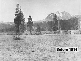
| The 1914-17 series of explosive eruptions at Lassen Peak, California, were some of the first volcanic eruptions to be extensively photographed, largely by Benjamin Franklin Loomis, a local businessman and amateur photographer. As shown in the left photograph, the northeastern flank of Lassen Peak was covered by mature conifer forest before 1914. The photograph on the right, taken by Loomis in June 1915 from nearly the same location shows the devastation caused by the two most powerful eruptions in the series, those of May 19 and 22 of that year. The large rock in the foreground is a piece of the lava dome that filled Lassen’s summit crater during the week before the May 19 eruption and was carried to its present location by the avalanche caused by this eruption. Today, this rock can be seen on the Devastated Area Interpretive Trail. The appearance of Lassen’s northeastern flank was little changed for 50 years after the eruptions, while seedlings struggled to regain a foothold, but today young vigorously growing trees are obscuring the devastation and reclaiming the area as forest. (Photographs courtesy of the National Park Service.) | |
Late on the afternoon of
May 22, after two quiet days, Lassen Peak exploded in a powerful eruption that
blasted rock fragments and pumice high into the air, creating the larger and
deeper of the two craters seen near the summit of the volcano today. A huge
column of volcanic ash and gas rose more than 30,000 feet into the air and was
visible from as far away as Eureka, 150 miles to the west.
Pumice falling onto the
northeastern slope of Lassen Peak generated a high-speed avalanche of hot ash,
pumice, rock fragments, and gas, called a pyroclastic flow, that swept down
the side of the volcano, devastating a 3-square-mile area. The pyroclastic flow
rapidly incorporated and melted snow in its path. The water from the melted
snow transformed the flow into a highly fluid lahar that followed the path of
the May 19-20 lahar and rushed nearly 10 miles down Lost Creek to Old Station.
This new lahar released a large volume of water that flooded lower Hat CreekValley
a second time.
The powerful climactic eruption of May 22 also swept away the northeast lobe of the lava flow extruded 2 days earlier. The eruption produced smaller mudflows on all flanks of Lassen Peak, deposited a layer of volcanic ash and pumice traceable for 25 miles to the northeast, and rained fine ash at least as far away as Winnemucca, Nevada, 200 miles to the east.
|
GENERALIZED
MAP OF DEPOSITS FROM LASSEN PEAK'S MAY 1915 ERUPTIONS
|
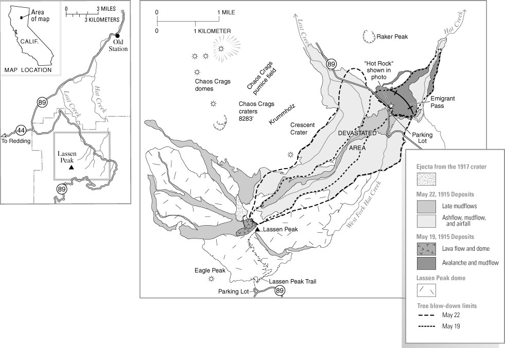 |
| The May 1915
eruptions of Lassen Peak destroyed a 3-square-mile area, now simply called
the Devastated Area, on the flank of the volcano. On the evening of May 19, a large steam explosion fragmented the still hot lava dome that had filled Lassen’s summit crater during the previous week, blasting out a new crater at the volcano’s summit and creating an avalanche of hot lava blocks, volcanic debris, and snow. melted, a huge mudflow of volcanic materials, called a lahar, was generated. The lahar rushed 7 miles down Lost Creek, where it released huge volumes of water, flooding the lower Hat Creek Valley. The avalanche, lahars, and floods produced by this explosion uprooted and carried away 100-foot-tall trees with ease and destroyed six ranch houses. During the night of May 19-20 new lava welled up into and filled the crater created by the steam explosion. On May 22 Lassen Peak exploded again in a powerful climactic eruption that blasted rock fragments and pumice high into the air, creating the larger and deeper of the two craters seen near the summit of the volcano today and generating a column of volcanic ash and gas. A high-speed avalanche of hot ash, pumice, rock fragments, and gas, called a pyroclastic flow, swept down the side of the volcano. Trees that were still standing after the May 19 eruption were blown down, with their trunks left lying on the ground pointing away from the volcano. The pyroclastic flow rapidly melted snow in its path, creating a lahar that followed the path of the lahar 2 days earlier and rushed down Lost Creek to Old Station, releasing water that again flooded lower Hat Creek Valley. |
For several years after
the May 22, 1915, eruption, spring snowmelt percolating down into Lassen Peak
triggered steam explosions, indicating that rocks beneath the volcano’s
surface remained hot. Particularly vigorous steam explosions in May 1917 blasted
out the second of the two craters now seen near the volcano’s summit.
Steam vents could be found in the area of these craters into the 1950’s
but gradually waned and are difficult to locate today. Lassen Peak sleeps again,
but active steam vents, hot springs, and bubbling pools of hot mud are still
found elsewhere in Lassen Volcanic National Park. No one can say when, but it
is almost certain that the Lassen area will experience volcanic eruptions again.
Michael A. Clynne, Robert L. Christiansen, Tracey J. Felger, Peter H. Stauffer, and James W. Hendley II
Graphics
by Sara Boore and Susan Mayfield
Web design by Carolyn Donlin
Banner design by Bobbie Myers
COOPERATING
ORGANIZATIONS
Lassen Loomis Museum Association
National Park Service
U.S. Forest Service
Related
Fact Sheets
Living With Volcanic Risk in the Cascades (USGS Fact
Sheet 165-97)
What are Volcano Hazards (USGS Fact Sheet 002-97)
Pictorial History of the Lassen Volcano by Benjamin Franklin Loomis
(1926, re-published by the Lassen Loomis Museum Association)
See a list
of other volcano-related
fact sheets published by the U.S. Geological Survey
PDF version of this fact sheet (588 KB)
U.S. GEOLOGICAL SURVEY—REDUCING THE RISK FROM
VOLCANO HAZARDS
Learn more about volcanoes at the USGS Volcano
Hazards Program website
Download a PDF version of this fact sheet (588 Kb)
Download a free copy of Adobe Acrobat Reader
For questions about the content of this report, contact Mike Clynne
URL of this page:
https://pubs.usgs.gov/fs/1998/fs173-98/
Maintained by: Michael Diggles
Created: January 20, 2001
Last modified: April 28, 2005 (mfd)