General Information Product 113
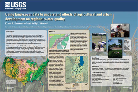
IntroductionThe Land-Cover Trends project is a collaborative effort between the Geographic Analysis and Monitoring Program of the U.S. Geological Survey (USGS), the U.S. Environmental Protection Agency (EPA) and the National Aeronautics and Space Administration (NASA) to understand the rates, trends, causes, and consequences of contemporary land-use and land-cover change in the United States. The data produced from this research can lead to an enriched understanding of the drivers of future landuse change, effects on environmental systems, and any associated feedbacks. USGS scientists are using the EPA Level III ecoregions as the geographic framework to process geospatial data collected between 1973 and 2000 to characterize ecosystem responses to land-use changes. General land-cover classes for these periods were interpreted from Landsat Multispectral Scanner, Thematic Mapper, and Enhanced Thematic Mapper Plus imagery to categorize and evaluate land-cover change using a modified Anderson Land-Use/Land-Cover Classification System for image interpretation. |
First posted June 17, 2010 For additional information contact: Part or all of this report is presented in Portable Document Format (PDF); the latest version of Adobe Reader or similar software is required to view it. Download the latest version of Adobe Reader, free of charge. |
Karstensen, K.A. and Warner, K.L., 2010, Using land-cover data to understand effects of agricultural and urban development on regional water quality: U.S. Geological Survey General Information Product 113, 1 p.

![]() U.S. Department of the Interior |
U.S. Geological Survey
U.S. Department of the Interior |
U.S. Geological Survey
URL: http://pubsdata.usgs.gov/pubs/gip/113/index.html
Page Contact Information: GS Pubs Web Contact
Page Last Modified: Wednesday, 30-Nov-2016 12:20:33 EST
