
Introduction
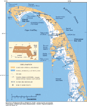
The Cape Cod National Seashore (CCNS), Cape Cod, Massachusetts (fig. 1), is underlain by four lenses of fresh ground water the Nauset, Chequesset, Pamet, and Pilgrim flow lenses, which are bounded laterally and below by saltwater (figs. 2, 3). These four flow lenses constitute the Lower Cape Cod aquifer system and are the only source of drinking water for the communities of Eastham, Wellfleet, Truro, and Provincetown, and for the various National Park Service facilities throughout the CCNS. Also, ground-water discharge from these lenses provides the primary source of water for the numerous kettle-hole ponds, streams, and wetlands throughout Lower Cape Cod. This discharge also helps to maintain the biological diversity and productivity of estuaries and salt marshes.
| Figure 1. The Lower Cape Cod aquifer system in Cape Cod, Massachusetts, is composed of four flow lenses, as shown by the water-table contours. Ground water flows from the centers of the water-table mounds toward the coast. Image enlarged |
 |
As land development and water demand increase, and as wastewater continues to be returned to the aquifer system through onsite septic systems, environmental managers are becoming concerned about possible long-term effects of these activities on the Lower Cape Cod aquifer system. In response to these concerns, the USGS, in cooperation with the National Park Service (NPS), Massachusetts Executive Office of Environmental Affairs, Cape Cod Commission, and the Towns of Eastham, Provincetown, Truro, and Wellfleet, began an investigation in 2000 to improve the understanding of the hydrogeology of the Lower Cape Cod aquifer system and to assess possible hydrologic effects of proposed water-management strategies.
This report provides a brief overview of the hydrogeology of the Lower Cape Cod aquifer system and the importance of ground-water levels and flow to the ecology of the Cape Cod National Seashore freshwater and estuarine ecosystems. Also, the report includes a discussion of the implications of future changes to the ground-water system and their effects on ecosystems and water resources of Lower Cape Cod. For a more detailed description and analysis of ground-water flow in the Lower Cape Cod aquifer system, refer to U.S. Geological Survey (USGS) Scientific Investigations Report 2004-5014 (Masterson, 2004).
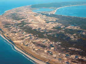 |
Figure 2. The Pilgrim flow lens, like the other flow lenses of the Lower Cape Cod aquifer system, is bounded laterally by the Atlantic Ocean and Cape Cod Bay. Rainfall that reaches the water table as recharge eventually leaves the aquifer system as ground-water discharge along the coast. View looking southeast. Image enlarged |