General Information Product 55
Poster PDF (4.8 MB)
|
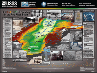
AbstractThe U.S. Geological Survey (USGS), one of the principal Federal agencies responsible for the collection and interpretation of water-resources data, works with other Federal, State, local, tribal, and academic entities to ensure that accurate and timely data are available for making decisions regarding public welfare and property during natural disasters and to increase public awareness of the hazards that occur with such disasters. The Red River of the North Basin has a history of flooding and this poster is designed to increase public awareness of that history and of the factors that contribute to flooding. |
| For additional information contact: Director, North Dakota Water Science Center U.S. Geological Survey 821 East Interstate Avenue Bismarck, ND 58503-1199 World Wide Web: http://nd.water.usgs.gov/ |
Document Accessibility: Adobe Systems Incorporated has information about PDFs and the visually impaired. This information provides tools to help make PDF files accessible. These tools convert Adobe PDF documents into HTML or ASCII text, which then can be read by a number of common screen-reading programs that synthesize text as audible speech. In addition, an accessible version of Acrobat Reader 7.0 for Windows (English only), which contains support for screen readers, is available. These tools and the accessible reader may be obtained free from Adobe at Adobe Access. |

![]() U.S. Department of the Interior | U.S. Geological Survey
U.S. Department of the Interior | U.S. Geological Survey
URL: http://pubsdata.usgs.gov/pubs/gip/2007/55/index.html
Questions or Assistance: Contact USGS
Last modified: Wednesday, 30-Nov-2016 12:18:18 EST