General Information Product 88
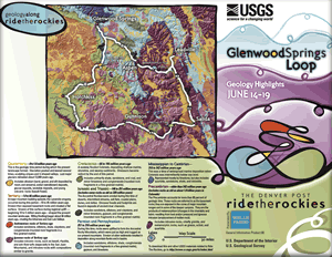 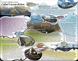 The author provides a brief description of the geology along the route for each day of the ride, from June 14 through June 19, 2009. Ride the Rockies begins and ends in Glenwood Springs, with stops in Hotchkiss, Gunnison, Salida, Leadville, Aspen, and back to Glenwood Springs, Colorado. A small, generalized geologic map also is shown. |
First posted May 28, 2009 To download other USGS materials related to Ride The Rockies, go to http://www.cr.usgs.gov/rtr/ Part or all of this report is presented in Portable Document Format (PDF); the latest version of Adobe Reader or similar software is required to view it. Download the latest version of Adobe Reader, free of charge. |
Slate, Janet, 2009, Geology highlights for Ride the Rockies 2009: U.S. Geological Survey General Information Product 88, 2 p.

![]() U.S. Department of the Interior |
U.S. Geological Survey
U.S. Department of the Interior |
U.S. Geological Survey
URL: http://pubsdata.usgs.gov/pubs/gip/88/index.html
Page Contact Information: GS Pubs Web Contact
Page Last Modified: Wednesday, 30-Nov-2016 12:19:35 EST
