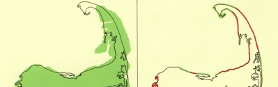
Figure 21a.
About 6,000 years ago, before extensive wave erosion of the glacial deposits had occurred, the glacial Cape probably resembled the map as shown on the left.
Figure 21b.
The present pattern of erosion is shown on the map on the right. Red shows shoreline undergoing wave erosion; green shows shoreline undergoing deposition. However, in many places, the shoreline of the depositional features is migrating landward.
|