
Over geologic time, plate movements in concert with other geologic processes, such as glacial and stream erosion, have created some of nature's most magnificent scenery. The Himalayas, the Swiss Alps, and the Andes are some spectacular examples. Yet violent earthquakes related to plate tectonics have caused terrible catastrophes -- such as the magnitude-7.7 earthquake that struck the Chinese province of Hebei in 1976 and killed as many as 800,000 people.
Most earthquakes and volcanic eruptions do not strike randomly but occur in specific areas, such as along plate boundaries. One such area is the circum-Pacific Ring of Fire, where the Pacific Plate meets many surrounding plates. The Ring of Fire is the most seismically and volcanically active zone in the world.
Because many major population centers are located near active fault zones, such as the San Andreas, millions of people have suffered personal and economic losses as a result of destructive earthquakes, and even more have experienced earthquake motions. Not surprisingly, some people believe that, when the "Big One" hits, California will suddenly "break off" and "fall into the Pacific," or that the Earth will "open up" along the fault and "swallow" people, cars, and houses. Such beliefs have no scientific basis whatsoever. Although ground slippage commonly takes place in a large earthquake, the Earth will not open up. Nor will California fall into the sea, because the fault zone only extends about 15 km deep, which is only about a quarter of the thickness of the continental crust. Furthermore, California is composed of continental crust, whose relatively low density keeps it riding high, like an iceberg above the ocean.

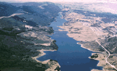
Aerial view, looking north toward San Francisco, of Crystal Springs Reservoir, which follows the San Andreas fault zone. (Photograph by Robert E. Wallace, USGS.)
Like all transform plate boundaries, the San Andreas is a strike-slip fault, movement along which is dominantly horizontal. Specifically, the San Andreas fault zone separates the Pacific and North American Plates, which are slowly grinding past each other in a roughly north-south direction. The Pacific Plate (western side of the fault) is moving horizontally in a northerly direction relative to the North American Plate (eastern side of the fault). Evidence of the sideways shift of these two landmasses can be found all along the fault zone, as seen from the differences in topography, geologic structures, and, sometimes, vegetation of the terrain from one side of the fault to the other. For example, the San Andreas runs directly along Crystal Springs Reservoir on the San Francisco Peninsula. Topographically, this reservoir fills a long, straight, narrow valley that was formed by erosion of the easily erodible rocks mashed within the fault zone.
Movement along the San Andreas can occur either in sudden jolts or in a slow, steady motion called creep. Fault segments that are actively creeping experience many small to moderate earthquakes that cause little or no damage. These creeping segments are separated by segments of infrequent earthquake activity (called seismic gaps), areas that are stuck or locked in place within the fault zone. Locked segments of the fault store a tremendous amount of energy that can build up for decades, or even centuries, before being unleashed in devastating earthquakes. For example, the Great San Francisco Earthquake (8.3-magnitude) in 1906 ruptured along a previously locked 430 km-long segment of the San Andreas, extending from Cape Men-docino south to San Juan Bautista.
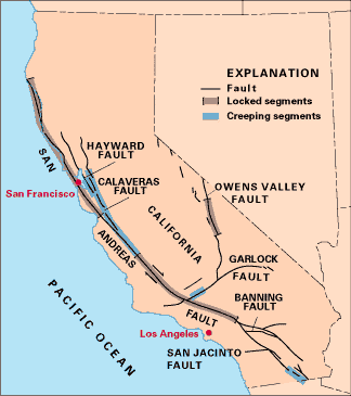
Map of the San Andreas and a few of the other faults in California, segments of which display different behavior: locked or creeping (see text). (Simplified from USGS Professional Paper 1515.)
The stresses that accumulate along a locked segment of the fault and the sudden release can be visualized by bending a stick until it breaks. The stick will bend fairly easily, up to a certain point, until the stress becomes too great and it snaps. The vibrations felt when the stick breaks represent the sudden release of the stored-up energy. Similarly, the seismic vibrations produced when the ground suddenly ruptures radiate out through the Earth's interior from the rupture point, called the earthquake focus. The geographic point directly above the focus is called the earthquake epicenter. In a major earthquake, the energy released can cause damage hundreds to thousands of kilometers away from the epicenter.
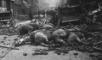
A dramatic photograph of horses killed by falling debris during the Great San Francisco Earthquake of 1906, when a locked segment of the San Andreas fault suddenly lurched, causing a devastating magnitude-8.3 earthquake. (Photograph by Edith Irvine, courtesy of Brigham Young University Library, Provo, Utah.)
The magnitude-7.1 Loma Prieta earthquake of October 1989 occurred along a segment of the San Andreas Fault which had been locked since the great 1906 San Francisco earthquake. Even though the earthquake's focus (approximately 80 km south of San Francisco) was centered in a sparsely populated part of the Santa Cruz Mountains, the earthquake still caused 62 deaths and nearly $6 billion in damage. Following the Loma Prieta earthquake, the fault remains locked from Pt. Arena, where it enters California from the ocean, south through San Francisco and the peninsula west of San Francisco Bay, thus posing the threat of a potential destructive earthquake occurring in a much more densely populated area.
The lesser known Hayward Fault running east of San Francisco Bay, however,
may pose a potential threat as great as, or perhaps even greater than, the
San Andreas. From the televised scenes of the damage caused by the 7.2-magnitude
earthquake that struck Kobe, Japan, on 16 January 1995, Bay Area residents
saw the possible devastation that could occur if a comparable size earthquake
were to strike along the Hayward Fault. This is because the Hayward and
the Nojima fault that produced the Kobe earthquake are quite similar in
several ways. Not only are they of the same type (strike-slip), they are
also about the same length (60p;80 km) and both cut through densely
populated urban areas, with many buildings, freeways, and other structures
built on unstable bay landfill.
On 17 January 1994, one of the costliest natural disasters in United States history struck southern California. A magnitude-6.6 earthquake hit near Northridge, a community located in the populous San Fernando Valley within the City of Los Angeles, California. This disaster, which killed more than 60 people, caused an estimated $30 billion in damage, nearly five times that resulting from the Loma Prieta earthquake. The Northridge earthquake did not directly involve movement along one of the strands of the San Andreas Fault system. It instead occurred along the Santa Monica Mountains Thrust Fault, one of several smaller, concealed faults (called blind thrust faults) south of the San Andreas Fault zone where it bends to the east, roughly paralleling the Transverse Mountain Range. With a thrust fault, whose plane is inclined to the Earth's surface, one side moves upward over the other. Movement along a blind thrust fault does not break the ground surface, thus making it difficult or impossible to map these hidden but potentially dangerous faults. Although scientists have found measurable uplift at several places in the Transverse Range, they have not found any conclusive evidence of ground rupture from the 1994 Northridge earthquake. Similar earthquakes struck the region in 1971 and 1987; the San Fernando earthquake (1971) caused substantial damage, including the collapse of a hospital and several freeway overpasses.
Not all fault movement is as violent and destructive. Near the city of Hollister in central California, the Calaveras Fault bends toward the San Andreas. Here, the Calaveras fault creeps at a slow, steady pace, posing little danger. Much of the Calaveras fault creeps at an average rate of 5 to 6 mm/yr. On average, Hollister has some 20,000 earthquakes a year, most of which are too small to be felt by residents. It is rare for an area undergoing creep to experience an earthquake with a magnitude greater than 6.0 because stress is continually being relieved and, therefore, does not accumulate. Fault-creep movement generally is non-threatening, resulting only in gradual offset of roads, fences, sidewalks, pipelines, and other structures that cross the fault. However, the persistence of fault creep does pose a costly nuisance in terms of maintenance and repair.
Mid-plate earthquakes -- those occurring in the interiors of plates -- are much less frequent than those along plate boundaries and more difficult to explain. Earthquakes along the Atlantic seaboard of the United States are most likely related in some way to the westward movement of the North American Plate away from the Mid-Atlantic Ridge, a continuing process begun with the break-up of Pangaea. However, the causes of these infrequent earthquakes are still not understood.
East Coast earthquakes, such as the one that struck Charleston, South Carolina, in 1886 are felt over a much larger area than earthquakes occurring on the West Coast, because the eastern half of the country is mainly composed of older rock that has not been fractured and cracked by frequent earthquake activity in the recent geologic past. Rock that is highly fractured and crushed absorbs more seismic energy than rock that is less fractured. The Charleston earthquake, with an estimated magnitude of about 7.0, was felt as far away as Chicago, more than 1,300 km to the northwest, whereas the 7.1-magnitude Loma Prieta earthquakes was felt no farther than Los Angeles, about 500 km south. The most widely felt earthquakes ever to strike the United States were centered near the town of New Madrid, Missouri, in 1811 and 1812. Three earthquakes, felt as far away as Washington D.C., were each estimated to be above 8.0 in magnitude. Most of us do not associate earthquakes with New York City, but beneath Manhattan is a network of intersecting faults, a few of which are capable of causing earthquakes. The most recent earthquake to strike New York City occurred in 1985 and measured 4.0 in magnitude, and a pair of earthquakes (magnitude 4.0 and 4.5) shook Reading, Pennsylvania, in January 1994 causing minor damage.
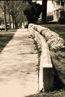
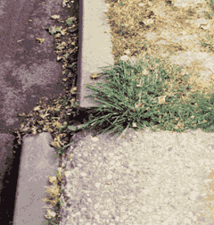
Left: Creeping along the Calaveras fault has bent the retaining wall and offset the sidewalk along 5th Street in Hollister, California (about 75 km south-southeast of San Jose). Right: Close-up of the offset of the curb. (Photographs by W. Jacquelyne Kious.)
We know in general how most earthquakes occur, but can we predict when they will strike? This question has challenged and frustrated scientists studying likely precursors to moderate and large earthquakes. Since the early 1980s, geologists and seismologists have been intensively studying a segment of the San Andreas near the small town of Parkfield, located about halfway between San Francisco and Los Angeles, to try to detect the physical and chemical changes that might take place -- both above and below ground -- before an earthquake strikes. The USGS and State and local agencies have blanketed Parkfield and the surrounding countryside with seismographs, creep meters, stress meters, and other ground-motion measurement devices.
 Ground-motion measurement system [40 k]
The Parkfield segment has experienced earthquakes measuring magnitude 6.0 about every 22 years on average since 1881. During the most recent two earthquakes (1934, 1966), the same section of the fault slipped and the amount of slippage was about the same. In 1983, this evidence, in addition to the earlier recorded history of earthquake activity, led the USGS to predict that there was a 95 percent chance of a 6.0 earthquake striking Parkfield before 1993. But the anticipated earthquake of magnitude 6.0 or greater did not materialize. The Parkfield experiment is continuing, and its primary goals remain unchanged: to issue a short-term prediction; to monitor and analyze geophysical and geochemical effects before, during, and after the anticipated earthquake; and to develop effective communications between scientists, emergency-management officials, and the public in responding to earthquake hazards.
While scientists are studying and identifying possible precursors leading to the next Parkfield earthquake, they also are looking at these same precursors to see if they may be occurring along other segments of the fault. Studies of past earthquakes, together with data and experience gained from the Parkfield experiment, have been used by geoscientists to estimate the probabilities of major earthquakes occurring along the entire San Andreas Fault system. In 1988, the USGS identified six segments of the San Andreas as most likely to be hit by a magnitude 6.5 or larger earthquake within the next thirty years (1988-2018). The Loma Prieta earthquake in 1989 occurred along one of these six segments. The Parkfield experiment and other studies carried out by the USGS as part of the National Earthquake Hazards Reduction Program have led to an increased official and public awareness of the inevitability of future earthquake activity in California. Consequently, residents and State and local officials have become more diligent in planning and preparing for the next big earthquake.
As with earthquakes, volcanic activity is linked to plate-tectonic processes. Most of the world's active above-sea volcanoes are located near convergent plate boundaries where subduction is occurring, particularly around the Pacific basin. However, much more volcanism -- producing about three quarters of all lava erupted on Earth -- takes place unseen beneath the ocean, mostly along the oceanic spreading centers, such as the Mid-Atlantic Ridge and the East Pacific Rise.
Subduction-zone volcanoes like Mount St. Helens (in Washington State) and Mount Pinatubo (Luzon, Philippines), are called composite cones and typically erupt with explosive force, because the magma is too stiff to allow easy escape of volcanic gases. As a consequence, tremendous internal pressures mount as the trapped gases expand during ascent, before the pent-up pressure is suddenly released in a violent eruption. Such an explosive process can be compared to putting your thumb over an opened bottle of a carbonated drink, shaking it vigorously, and then quickly removing the thumb. The shaking action separates the gases from the liquid to form bubbles, increasing the internal pressure. Quick release of the thumb allows the gases and liquid to gush out with explosive speed and force.
In 1991, two volcanoes on the western edge of the Philippine Plate produced major eruptions. On June 15, Mount Pinatubo spewed ash 40 km into the air and produced huge ash flows (also called pyroclastic flows) and mudflows that devastated a large area around the volcano. Pinatubo, located 90 km from Manila, had been dormant for 600 years before the 1991 eruption, which ranks as one of the largest eruptions in this century. Also in 1991, Japan's Unzen Volcano, located on the Island of Kyushu about 40 km east of Nagasaki, awakened from its 200-year slumber to produce a new lava dome at its summit. Beginning in June, repeated collapses of this active dome generated destructive ash flows that swept down its slopes at speeds as high as 200 km per hour. Unzen is one of more than 75 active volcanoes in Japan; its eruption in 1792 killed more than 15,000 people--the worst volcanic disaster in the country's history.
 Mount Pinatubo plume [85 k]
While the Unzen eruptions have caused deaths and considerable local damage, the impact of the June 1991 eruption of Mount Pinatubo was global. Slightly cooler than usual temperatures recorded worldwide and the brilliant sunsets and sunrises have been attributed to this eruption that sent fine ash and gases high into the stratosphere, forming a large volcanic cloud that drifted around the world. The sulfur dioxide (SO2) in this cloud -- about 22 million tons -- combined with water to form droplets of sulfuric acid, blocking some of the sunlight from reaching the Earth and thereby cooling temperatures in some regions by as much as 0.5 °C. An eruption the size of Mount Pinatubo could affect the weather for a few years. A similar phenomenon occurred in April of 1815 with the cataclysmic eruption of Tambora Volcano in Indonesia, the most powerful eruption in recorded history. Tambora's volcanic cloud lowered global temperatures by as much as 3 °C. Even a year after the eruption, most of the northern hemisphere experienced sharply cooler temperatures during the summer months. In part of Europe and in North America, 1816 was known as "the year without a summer."
Apart from possibly affecting climate, volcanic clouds from explosive eruptions also pose a hazard to aviation safety. During the past two decades, more than 60 airplanes, mostly commercial jetliners, have been damaged by in-flight encounters with volcanic ash. Some of these encounters have resulted in the power loss of all engines, necessitating emergency landings. Luckily, to date no crashes have happened be-cause of jet aircraft flying into volcanic ash.
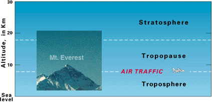
Diagram showing the lower two layers of the atmosphere: the troposphere and the stratosphere. The tropopause--the boundary between these two layers--varies in altitude from 8 to 18 km (dashed white lines), depending on Earth latitude and season of the year. The summit of Mt. Everest (inset photograph) and the altitudes commonly flown by commercial jetliners are given for reference. (Photograph by David G. Howell, USGS.)
Since the year A.D. 1600, nearly 300,000 people have been killed by volcanic eruptions. Most deaths were caused by pyroclastic flows and mudflows, deadly hazards which often accompany explosive eruptions of subduction-zone volcanoes. Pyroclastic flows, also called nuées ardentes ("glowing clouds" in French), are fast-moving, avalanche-like, ground-hugging incandescent mixtures of hot volcanic debris, ash, and gases that can travel at speeds in excess of 150 km per hour. Approximately 30,000 people were killed by pyroclastic flows during the 1902 eruption of Mont Pelée on the Island of Martinique in the Caribbean. In March-April 1982, three explosive eruptions of El Chichón Volcano in the State of Chiapas, southeastern Mexico, caused the worst volcanic disaster in that country's history. Villages within 8 km of the volcano were destroyed by pyroclastic flows, killing more than 2,000 people.
Mudflows (also called debris flows or lahars, an Indonesian term for volcanic mudflows) are mixtures of volcanic debris and water. The water usually comes from two sources: rainfall or the melting of snow and ice by hot volcanic debris. Depending on the proportion of water to volcanic material, mudflows can range from soupy floods to thick flows that have the consistency of wet cement. As mudflows sweep down the steep sides of composite volcanoes, they have the strength and speed to flatten or bury everything in their paths. Hot ash and pyroclastic flows from the eruption of the Nevado del Ruiz Volcano in Colombia, South America, melted snow and ice atop the 5,390-m-high Andean peak; the ensuing mudflows buried the city of Armero, killing 25,000 people.
 Armero, Colombia [88 k]
Eruptions of Hawaiian and most other mid-plate volcanoes differ greatly from those of composite cones. Mauna Loa and Kilauea, on the island of Hawaii, are known as shield volcanoes, because they resemble the wide, rounded shape of an ancient warrior's shield. Shield volcanoes tend to erupt non-explosively, mainly pouring out huge volumes of fluid lava. Hawaiian-type eruptions are rarely life threatening because the lava advances slowly enough to allow safe evacuation of people, but large lava flows can cause considerable economic loss by destroying property and agricultural lands. For example, lava from the ongoing eruption of Kilauea, which began in January 1983, has destroyed more than 200 structures, buried kilometers of highways, and disrupted the daily lives of local residents. Because Hawaiian volcanoes erupt frequently and pose little danger to humans, they provide an ideal natural laboratory to safely study volcanic phenomena at close range. The USGS Hawaiian Volcano Observatory, on the rim of Kilauea, was among the world's first modern volcano observatories, established early in this century.
 Wahaula Visitor Center, Hawaii
[40 k]
Wahaula Visitor Center, Hawaii
[40 k]In recorded history, explosive eruptions at subduction-zone (convergent-boundary) volcanoes have posed the greatest hazard to civilizations. Yet scientists have estimated that about three quarters of the material erupted on Earth each year originates at spreading mid-ocean ridges. However, no deep submarine eruption has yet been observed "live" by scientists. Because the great water depths preclude easy observation, few detailed studies have been made of the numerous possible eruption sites along the tremendous length (50,000 km) of the global mid-oceanic ridge system. Recently however, repeated surveys of specific sites along the Juan de Fuca Ridge, off the coast of the Oregon and Washington, have mapped deposits of fresh lava, which must have been erupted sometime between the surveys. In June 1993, seismic signals typically associated with submarine eruptions -- called T-phases -- were detected along part of the spreading Juan de Fuca Ridge and interpreted as being caused by eruptive activity.
Iceland, where the Mid-Atlantic Ridge is exposed on land, is a different story. It is easy to see many Icelandic volcanoes erupt non-explosively from fissure vents, in similar fashion to typical Hawaiian eruptions; others, like Hekla Volcano, erupt explosively. (After Hekla's catastrophic eruption in 1104, it was thought in the Christian world to be the "Mouth to Hell.") The voluminous, but mostly non-explosive, eruption at Lakagígar (Laki), Iceland, in 1783, resulted in one of the world's worst volcanic disasters. About 9,000 people -- almost 20% of the country's population at the time -- died of starvation after the eruption, because their livestock had perished from grazing on grass contaminated by fluorine-rich gases emitted during this eight month-long eruption.
Major earthquakes occurring along subduction zones are especially hazardous, because they can trigger tsunamis (from the Japanese word tsunami meaning "harbor wave") and pose a potential danger to coastal communities and islands that dot the Pacific. Tsunamis are often mistakenly called "tidal waves" when, in fact, they have nothing to do with tidal action. Rather, tsunamis are seismic sea waves caused by earthquakes, submarine landslides, and, infrequently, by eruptions of island volcanoes. During a major earthquake, the seafloor can move by several meters and an enormous amount of water is suddenly set into motion, sloshing back and forth for several hours. The result is a series of waves that race across the ocean at speeds of more than 800 km per hour, comparable to those of commercial jetliners. The energy and momentum of these transoceanic waves can take them thousands of kilometers from their origin before slamming into far-distant islands or coastal areas.
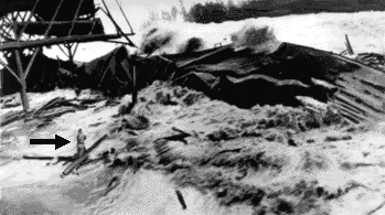
A giant wave engulfs the pier at Hilo, Hawaii, during the 1946 tsunami, which killed 159 people. The arrow points to a man who was swept away seconds later. (Retouched photograph courtesy of NOAA/EDIS.)
To someone on a ship in the open ocean, the passage of a tsunami wave would barely elevate the water surface. However, when it reaches shallower water near the coastline and "touches bottom," the tsunami wave increases in height, piling up into an enormous wall of water. As a tsunami approaches the shore, the water near shore commonly recedes for several minutes -- long enough for someone to be lured out to collect exposed sea shells, fish, etc. -- before suddenly rushing back toward land with frightening speed and height.
The 1883 eruption of Krakatau Volcano, located in the Sunda Straits between the islands of Sumatra and Java, Indonesia, provides an excellent example of an eruption-caused tsunami. A series of tsunamis washed away 165 coastal villages on Java and Sumatra, killing 36,000 people. The larger tsunamis were recorded by tide gauges as far away as the southern coast of the Arabian Peninsula-more than 7,000 km from Krakatau!
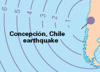 Travel
times for tsunamis [55 k]
Travel
times for tsunamis [55 k]Because of past killer tsunamis, which have caused hundreds of deaths on the Island of Hawaii and elsewhere, the International Tsunami Information Center was created in 1965. This center issues tsunami warnings based on earthquake and wave-height information gathered from seismic and tide-gauge stations located around the Pacific Ocean basin and on Hawaii.
Many of the Earth's natural resources of energy, minerals, and soil are concentrated near past or present plate boundaries. The utilization of these readily available resources have sustained human civilizations, both now and in the past.
Volcanoes can clearly cause much damage and destruction, but in the long term they also have benefited people. Over thousands to millions of years, the physical breakdown and chemical weathering of volcanic rocks have formed some of the most fertile soils on Earth. In tropical, rainy regions, such as the windward (northeastern) side of the Island of Hawaii, the formation of fertile soil and growth of lush vegetation following an eruption can be as fast as a few hundred years. Some of the earliest civilizations (for example, Greek, Etruscan, and Roman) settled on the rich, fertile volcanic soils in the Mediterranean-Aegean region. Some of the best rice-growing regions of Indonesia are in the shadow of active volcanoes. Similarly, many prime agricultural regions in the western United States have fertile soils wholly or largely of volcanic origin.
Most of the metallic minerals mined in the world, such as copper, gold, silver, lead, and zinc, are associated with magmas found deep within the roots of extinct volcanoes located above subduction zones. Rising magma does not always reach the surface to erupt; instead it may slowly cool and harden beneath the volcano to form a wide variety of crystalline rocks (generally called plutonic or granitic rocks). Some of the best examples of such deep-seated granitic rocks, later exposed by erosion, are magnificently displayed in California's Yosemite National Park. Ore deposits commonly form around the magma bodies that feed volcanoes because there is a ready supply of heat, which convectively moves and circulates ore-bearing fluids. The metals, originally scattered in trace amounts in magma or surrounding solid rocks, become concentrated by circulating hot fluids and can be redeposited, under favorable temperature and pressure conditions, to form rich mineral veins.
The active volcanic vents along the spreading mid-ocean ridges create ideal environments for the circulation of fluids rich in minerals and for ore deposition. Water as hot as 380 °C gushes out of geothermal springs along the spreading centers. The water has been heated during circulation by contact with the hot volcanic rocks forming the ridge. Deep-sea hot springs containing an abundance of dark-colored ore minerals (sulfides) of iron, copper, zinc, nickel, and other metals are called "black smokers." On rare occasions, such deep-sea ore deposits are later exposed in remnants of ancient oceanic crust that have been scraped off and left ("beached") on top of continental crust during past subduction processes. The Troodos Massif on the Island of Cyprus is perhaps the best known example of such ancient oceanic crust. Cyprus was an important source of copper in the ancient world, and Romans called copper the "Cyprian metal"; the Latin word for copper is cyprium.
Oil and natural gas are the products of the deep burial and decomposition of accumulated organic material in geologic basins that flank mountain ranges formed by plate-tectonic processes. Heat and pressure at depth transform the decomposed organic material into tiny pockets of gas and liquid petroleum, which then migrate through the pore spaces and larger openings in the surrounding rocks and collect in reservoirs, generally within 5 km of the Earth's surface. Coal is also a product of accumulated decomposed plant debris, later buried and compacted beneath overlying sediments. Most coal originated as peat in ancient swamps created many millions of years ago, associated with the draining and flooding of landmasses caused by changes in sea level related to plate tectonics and other geologic processes. For example, the Appalachian coal deposits formed about 300 million years ago in a low-lying basin that was alternately flooded and drained.
 Half Dome, Yosemite National Park
[148 k]
Half Dome, Yosemite National Park
[148 k]Geothermal energy can be harnessed from the Earth's natural heat associated with active volcanoes or geologically young inactive volcanoes still giving off heat at depth. Steam from high-temperature geothermal fluids can be used to drive turbines and generate electrical power, while lower temperature fluids provide hot water for space-heating purposes, heat for greenhouses and industrial uses, and hot or warm springs at resort spas. For example, geothermal heat warms more than 70 percent of the homes in Iceland, and The Geysers geothermal field in Northern California produces enough electricity to meet the power demands of San Francisco. In addition to being an energy resource, some geo-thermal waters also contain sulfur, gold, silver, and mercury that can be recovered as a byproduct of energy production.
 Geothermal powerplant, The Geysers
[60 k]
Geothermal powerplant, The Geysers
[60 k]As global population increases and more countries become industrialized, the world demand for mineral and energy resources will continue to grow. Because people have been using natural resources for millennia, most of the easily located mineral, fossil-fuel, and geothermal resources have already been tapped. By necessity, the world's focus has turned to the more remote and inaccessible regions of the world, such as the ocean floor, the polar continents, and the resources that lie deeper in the Earth's crust. Finding and developing such resources without damage to the environment will present a formidable challenge in the coming decades. An improved knowledge of the relationship between plate tectonics and natural resources is essential to meeting this challenge.
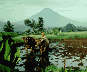
Farmer plowing a lush rice paddy in central Java, Indonesia; Sundoro Volcano looms in the background. The most highly prized rice-growing areas have fertile soils formed from the breakdown of young volcanic deposits. (Photograph by Robert I. Tilling, USGS.)
The long-term benefits of plate tectonics should serve as a constant reminder to us that the planet Earth occupies a unique niche in our solar system. Appreciation of the concept of plate tectonics and its consequences has reinforced the notion that the Earth is an integrated whole, not a random collection of isolated parts. The global effort to better understand this revolutionary concept has helped to unite the earth-sciences community and to underscore the linkages between the many different scientific disciplines. As we enter the 21st century, when the Earth's finite resources will be further strained by explosive population growth, earth scientists must strive to better understand our dynamic planet. We must become more resourceful in reaping the long-term benefits of plate tectonics, while coping with its short-term adverse impacts, such as earthquakes and volcanic eruptions.