
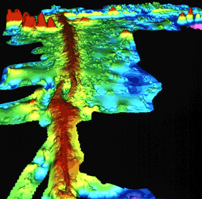
Computer-generated detailed topographic map of a segment of the Mid-Oceanic Ridge. "Warm" colors (yellow to red) indicate the ridge rising above the seafloor, and the "cool" colors (green to blue) represent lower elevations. This image (at latitude 9° north) is of a small part of the East Pacific Rise. (Imagery courtesy of Stacey Tighe, University of Rhode Island.)
![]() U.S. Department of the Interior |
U.S. Geological Survey
U.S. Department of the Interior |
U.S. Geological Survey
URL: https://pubsdata.usgs.gov/pubs/gip/dynamic/topomap.html
Page Contact Information: Molly Newbrough or Pubs Warehouse
Page Last Modified: Friday, July 11, 2025, 12:56:39 PM