
Introduction |
"The loveliest fleet of islands that lies anchored in any ocean." --Mark Twain
Few would quarrel with Mark Twain's vivid description of Hawaii, written after his 4-month stay in 1866. The Hawaiian Islands were discovered and settled around the 6th century A.D. by Polynesians sailing from islands, probably the Marquesas, in the southern tropical Pacific. Subsequently, a thousand years or more of cultural isolation passed before Hawaii was first visited by non-Polynesians. On January 18, 1778, during his third major voyage in the Pacific, the famous British navigator and explorer, Captain James Cook, sighted the Polynesians' secluded home. |
Cook named his discovery the "Sandwich Islands," in honor of the Earl of Sandwich, then
First Lord of the British Admiralty. Mark Twain's fleet of islands is larger than Rhode Island
and Connecticut combined. The island of Hawaii, commonly called the "Big Island," covers more
than twice the total area of the other islands. Hawaii, which became our 50th state in 1959, is now home for more than one million people and hosts many times that number of visitors each year. |
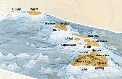
| The principal Hawaiian islands
(all capital letters) are the exposed tops of volcanoes that rise tens of thousands of feet above the ocean floor.
Some islands are made up of two or more volcanoes. Loihi Seamount, Hawaii's newest volcano, still lies
about 3,100 feet beneath the sea. (Modified by permission from a map published by Dynamic Graphics, Inc.,
Berkeley, California.) |
 � �
|
|
Back | Home | Forward
<https://pubs.usgs.gov/gip/hawaii/page05.html>
Maintained by John Watson
Updated 05.01.97