
Origin of the Hawaiian Islands |
||
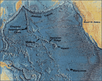 � �
Map of the Pacific basin showing the location of the Hawaiian Ridge-Emperor Seamount Chain in relation to some other features and localities mentioned in the text. (Base map reprinted by permission from World Ocean Floor Panorama by Bruce C. Heezen and Marie Tharp, Copyright 1977.) |
The Hawaiian Islands are the tops of gigantic volcanic mountains formed by
countless eruptions of fluid lava (1) over several million years; some tower more
than 30,000 feet above the sea floor.(2) These volcanic peaks rising above the
ocean surface represent only the tiny, visible part of an immense submarine
ridge, the Hawaiian Ridge--Emperor Seamount Chain, composed of more than 80 large
volcanoes. This range stretches across the Pacific sea floor from the Hawaiian
Islands to the Aleutian Trench. The length of the Hawaiian Ridge segment alone,
between the Big Island and Midway Island to the northwest, is about 1,600 miles,
roughly the distance from Washington, D.C., to Denver, Colorado. The amount of
lava erupted to form this huge ridge, about 186,000 cubic miles, is more than
enough to cover the State of California with a mile-thick layer.
(1) Scientists use the term lava for molten rock (and contained gases) that breaks through the Earth's surface, and the term magma for the molten rock underground. (2) The United States uses English units of measurements. For readers in the many countries that use metric units, a conversion table is given in the back of the booklet. |
|
Back | Home | Forward
<https://pubs.usgs.gov/gip/hawaii/page07.html>
Maintained by John Watson
Updated 05.01.97