
 � �
|
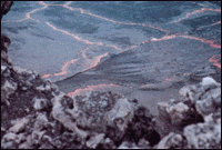
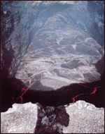
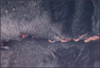
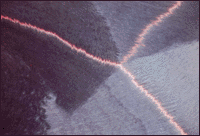
S urface movements of the active lava lake within Mauna Ulu crater in 1971 provide an instructive, but very small scale, analogy to movements of the Earth's tectonic plates. Left: View looking east and down (about 200 feet) at the lava-lake surface. Center: Closer view of moving slabs of solidified crust, ranging in size from a few feet to several tens of feet across but only a few inches thick, rafted by circulating lava beneath. Right: Even closer views of lake surface to show small-scale analogs to the three common types of boundaries between tectonic plates: Convergent boundary between two slabs of crust (upper); Divergent or spreading boundaries between three slabs (middle); and Transform fault (lower) offsetting the spreading boundary between two slabs. (Photographs by Wendell A. Duffield.) |
  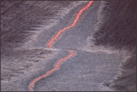 |
The century-long lava-lake activity at Halemaumau ceased after the explosive 1924 eruption; however, a lava lake was active there for about 8 months during the 1967-68 eruption. Not until the 1969-1974 Mauna Ulu eruptions, on Kilauea's upper east rift zone, however, did scientists have an opportunity to observe the development and behavior of a |
long-lived active lava lake outside the summit region of a Hawaiian volcano. The lava-lake behavior at Mauna Ulu, including movement and collision of thin plates of surface crust floating on circulating molten lava, provided a small-scale version of the Earth's global plate tectonics. |
Back | Home | Forward
<https://pubs.usgs.gov/gip/hawaii/page33.html>
Maintained by John Watson
Updated 05.01.97