
| Growth profiles of Kilauea's newest volcanic cone, built during the Pu'u 'O'o eruption. |
|
|
| Aerial view of some scarps of the Hilina Fault System, expressed as sharp cliffs on the south flank of Kilauea Volcano. (Photograph by Donald A. Swanson.) |
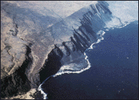
Repeated forceful intrusions of magma into the rift zones of Kilauea have pushed that volcano's south flank southward toward the sea. This seaward movement is readily measurable at rates as high as a few inches per year. Eventually the accumulated seaward movement causes the south flank to become unstable, ultimately resulting in a large earthquake. Such earthquakes occur periodically and are accompanied by substantial and sudden movements along faults cutting the south flank (the Hilina Fault System). For example, in response to a |
magnitude-7.2 earthquake beneath the area on November 29, 1975, points on
Kilauea's south flank dropped as much as 11 feet and shifted southward as much as
24 feet. The scarps (steep slopes) of the Hilina faults are well expressed as
palis (Hawaiian for cliffs) on Kilauea's south flank.
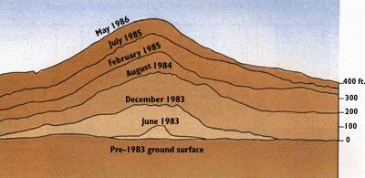
Prolonged eruptions on Kilauea's east rift zone have given scientists unprecedented opportunities to observe the growth of Hawaiian volcanic landforms. The 1969-74 eruptions created two prominent volcanic shields: a symmetrical 397-foot-high mound at Mauna Ulu (Hawaiian for "growing mountain") and, abutting it, a more irregular shield, 328 feet high, over the site of buried Alae Crater. The highest volcanic landform of historic age in Hawaii is the cone being built by the 1983-to-present Pu'u 'O'o eruption. By September 1986, this cone had grown to a height of more than 830 feet. |
Back | Home | Forward
<https://pubs.usgs.gov/gip/hawaii/page44.html>
Maintained by John Watson
Updated 05.01.97