
 � �
| It is useful to distinguish between the terms hazards and risks. Evaluation of hazards is based on geologic information only and considers the likelihood of destructive volcanic phenomena and products in a given area; assessment of risks evaluates the likelihood of loss of life and property in the area being considered. Thus, volcanic "risk" increases as the zones defined as hazardous become cultivated, populated, or otherwise developed. Even areas with a very low severity of volcanic hazards may be classified as high risk if they are densely populated. Hazards-zonation maps provide government officials and | |
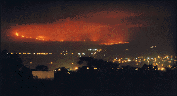
| Night view of the lava flows of the 1984 Mauna Loa eruption with lights of downtown Hilo in foreground. (Photograph by David Little.) |
Although the typically gentle Hawaiian eruptions pose little danger to people,
their lava flows can be highly destructive to populated and cultivated areas. For
example, the village of Kapoho was entirely destroyed during the 1960 eruption in
the lower east rift zone of Kilauea. More recently, flows from Kilauea's Pu'u
'O'o eruption have covered and destroyed dwellings and house lots in the Royal
Gardens subdivision on the volcano's southeastern flank. The outskirts of Hilo,
the largest city on the Big Island, with a population of about 40,000, are built
in part on the pahoehoe lava flows of the 1881 Mauna Loa eruption. During the
March-April 1984 eruption of Mauna Loa, Hilo was threatened. Lava flows advanced
nearly 16 miles in about 5 days, and a bright red glow in the sky over the area
of the incandescent flows could be seen on clear nights. The citizens and
officials of Hilo became increasingly concerned as the eruption continued.
Fortunately the flows stopped about 4 miles short of the nearest buildings on the
city's outskirts.
Because of the frequent eruptions of Kilauea and Mauna Loa, the Hawaiian Volcano Observatory conducts round-the-clock monitoring to detect early signs of impending activity and to advise local officials on a timely basis. A key component in reducing volcanic hazards is the preparation of volcanic-hazards zonation maps. These maps delineate the zones of relative severity of volcanic hazards based on an assessment of data on eruption frequency; nature of expected activity; and likely vent areas and lava-flow paths. |
the public with critical information that allows
them to assess the risks of volcanic hazards and apply the results in long-term
land-use planning, estimates of the socioeconomic and political impact of
eruptions, and preparation of contingency plans in case of volcanic emergencies.
A volcanic-hazards map has been prepared for the Big Island, in which the the areas of increasing relative severity of hazards from lava flows are designated "9" through "1." Related maps have been prepared for hazards from air-fall ash, ground failures, and subsidence. Similar volcanic hazards-assessment studies have been made for the islands of Maui and Oahu, although the expected frequency of future eruptions on those islands is much lower. Boundaries drawn between the hazard zones are necessarily gradational and reflect the judgment of experienced volcanologists. Hazards-assessment studies assume that probable future eruptive behavior is most likely to be similar to a given volcano's past behavior. As a volcano's eruptive history becomes better documented by additional studies, the hazards-zonation maps for it need to be revised and updated to reflect the incorporation of new and better information. |
Back | Home | Forward
<https://pubs.usgs.gov/gip/hawaii/page48.html>
Maintained by John Watson
Updated 05.01.97