
|
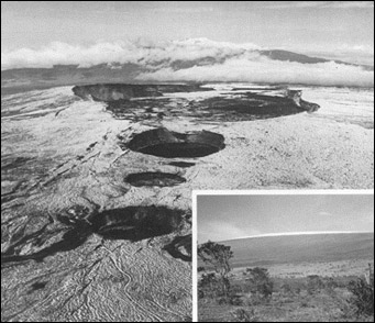
| Summit caldera and pit craters on Mauna Loa, Hawaii. The inset shows Mauna Loa as it appears from the Hawaiian Volcano Observatory, 240 kilometers away. |
Mauna Loa Volcano erupted in July 1975, following a quarter century of inactivity. The first hint of change leading up to the 1975 eruption was a marked increase in the number of earthquakes beginning in April 1974, more than a year before the eruption. Inflation or swelling of the summit of Mauna Loa was detected 4 months later during the annual "laser beam" remeasurement of horizontal distances across the summit crater. The 1974 set of measurements showed the first significant increases in the horizontal distances of the lines across the summit crater since the beginning of the precise distance monitoring program in 1967. The Hawaiian Volcano Observatory immediately alerted Hawaiian officials and the general public to the possible reawakening of Mauna Loa from its long slumber.
During the next 12 months, both the ground deformation and seismic networks on Mauna Loa were expanded. Records showed that the numbers of earthquakes and the rate of summit inflation increased steadily, reaching a climax during the summit eruption that began on July 5, 1975. The exact timing of the eruption could not be predicted, even though all premonitory indicators pointed toward an eruption any day. Although the earthquake frequency tapered off sharply in the weeks following the July eruption, swelling of the summit resumed, indicating that magma was continuing to accumulate in Mauna Loa's summit reservoir. Measurements made on six separate occasions over a period of a year and a half following the eruption all confirmed continued swelling. From analysis of the written records of the past historic eruptive behavior and the fact that both the earthquakes and swelling had extended out along the northeast rift, Observatory scientists suggested that a flank eruption on the northeast rift was likely sometime before the summer of 1978, .if Mauna Loa were to behave as it had for the past 200 years. This conclusion was conveyed to members of the Hawaiian Congressional delegation and Hawaii Civil Defense officials, announced to the media, and published in a scientific journal.
In fact, Mauna Loa did not erupt again until March 1984. The eruption began at the summit and spread to the northeast rift zone in a few hours. The resulting lava flows advanced to within 6 kilometers of Hilo before the 3-week-long eruption ended in early April.
These recent developments show that a few years of intensive monitoring and the short historic record (about 200 years) are simply inadequate to establish statistically reliable probabilities for the exact time and place of the next eruption.
Kilauea has been closely monitored for a longer period of time than Mauna Loa, but the necessary state of knowledge for prediction of eruptive activity has not been achieved. There have been some notable successes, however. For example, in the late 1960's and early 1970's, several eruptions were predicted with sufficient certainty 4 to 8 hours in advance, so that HVO scientists could advise officials of Hawaii Volcanoes National Park to evacuate certain sections. The park rangers were able to clear park visitors safely from the actual outbreak areas in ample time. But there also have been false alarms-- when all of the premonitory indicators signaled movement of magma from the summit reservoir, only to have the magma injected into the rift zones below ground without breaking through to the surface.
The latest eruption at Kilauea began in January 1983 along the east rift zone. Spectacular lava fountains in the first 3 years of the eruption produced lava flows that moved rapidly down the volcano's south flank and destroyed homes in the Royal Gardens subdivision. In 1986, the site of the eruption changed to a different vent. This phase of the eruption has produced much less magma, but even so many homes in the coastal town of Kalapana have been destroyed.
|
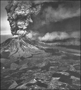
| Mount St. Helens about noon on May 18, 1980, some 3 hours after the beginning of the catastrophic eruption that devastated the area north of the volcano and showered ash over much of eastern Washington. |
The Geological Survey has published several fully illustrated volumes on the 1980
eruptions of Mount St. Helens:
In March and April of 1982, El Chichón--an obscure and largely forgotten volcano in southeastern Mexico--erupted violently. During three major explosive bursts (March 28, April 3, and April 4), El Chichón spewed about the same volume of air-fall ash as Mount St. Helens did during May 18, 1980, and generated high-velocity, incandescent, ground-hugging ash flows that leveled villages within about 8 kilometers of the volcano. El Chichón's eruptions were the most destructive in Mexico's history; the number of deaths attributed to the eruptions is unknown, but may exceed 500. In addition, the El Chichón eruptions were much more gas-rich than was the May 1980 eruption of Mount St. Helens and injected a very large volume of aerosols (mainly sulfuric acid particles) into the stratosphere. Unfortunately, although El Chichón was "discovered" in 1928, no systematic monitoring studies were carried out. Thus the 1982 eruptions came as a tragic surprise.Lipman, P.W., and Mullineaux, D. R., 1981, editors, The 1980 eruptions of Mount St. Helens, Washington: U.S. Geological Survey Professional Paper 1250, 844 p. (The most comprehensive collection of scientific articles available to date, containing 62 reports on diverse aspects of the 1980 eruptions.)
Foxworthy, B.L., and Hill, Mary, 1982, Volcano eruptions of 1980 at Mount St. Helens: The first 100 days: U.S. Geological Survey Professional Paper 1249, 125 p. (A description of the events during the first 100 days of the eruptive activity in nontechnical language that serves as a backdrop for the more technical articles in Professional Paper 1250.)
Tilling, R.l., 1987, Eruptions of Mount St. Helens: Past, Present, and Future: Reston, Va., U.S. Geological Survey general interest publication, 46 p. (A nontechnical overview of the geology and history of the past and present eruptive activity at Mt. St. Helens and speculations about its future behavior.)
|
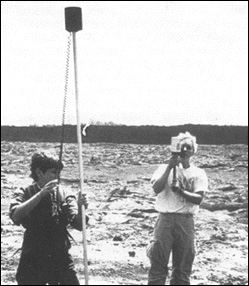
| HVO scientists making magnetic and geoelectric measurements over an active lava tube on Kilauea's East Rift Zone with the source vent Pu'u O'o in the background. (Photograph by J.D. Griggs, USGS.) |
|
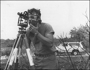
| Leveling survey on Kilauea's east rift zone with Pu'u O;o in the background. (Photograph by J.D. Griggs, USGS.) |
|
| Geologist programs an automated video time-lapse system on the north flank of Redoubt Volcano in Alaska. |