The May 18, 1980, eruption was the most destructive in the history of the United States. Novarupta (Katmai) Volcano, Alaska, erupted considerably more material in 1912, but owing to the isolation and sparse population of the region affected, there were no human deaths and little property damage. In contrast, Mount St. Helens' eruption in a matter of hours caused loss of lives and widespread destruction of valuable property, primarily by the debris avalanche, the lateral blast, and the mudflows.
Landscape changes caused by the May 18 eruption were readily seen on high-altitude photographs. Such images, however, cannot reveal the impacts of the devastation on people and their works. The May 18 eruption resulted in scores of injuries and the loss of 57 lives. Within the United States before May 18, 1980, only two known casualties had been attributed to volcanic activity--a photographer was struck by falling rocks during the explosive eruption of Kilauea Volcano, Hawaii, in 1924; and an Army sergeant who disappeared during the 1944 eruption of Cleveland Volcano, Chuginadak Island, Aleutians. Autopsies indicated that most of Mount St. Helens' vicitims died by asphyxiation from inhaling hot volcanic ash, and some by thermal and other injuries.
The lateral blast, debris avalanche, mudflows, and flooding caused extensive damage to land and civil works. All buildings and related manmade structures in the vicinity of Spirit Lake were buried. More than 200 houses and cabins were destroyed and many more were damaged in Skamania and Cowlitz Counties, leaving many people homeless. Many tens of thousands of acres of prime forest, as well as recreational sites, bridges, roads, and trails, were destroyed or heavily damaged. More than 185 miles of highways and roads and 15 miles of railways were destroyed or extensively damaged.


High-altitude color-infrared photographs of the Mount St. Helens region "before" and "after" the eruption of May 18, 1980. Note the changes in the shoreline of Spirit Lake (upper right corner). Green vegetation unaffected by the eruption appears as red (Photographs courtesy of NASA).
Trees amounting to more than 4 billion board feet of salable timber were damaged or destroyed, primarily by the lateral blast. At least 25 percent of the destroyed timber has been salvaged since September 1980. Hundreds of loggers have been involved in the timber-salvage operations, and, during peak summer months, more than 600 truckloads of salvaged timber were retrieved each day. Wildlife in the Mount St. Helens area also suffered heavily. The Washington State Department of Game estimated that nearly 7,000 big game animals (deer, elk, and bear) perished in the area most affected by the eruption, as well as all birds and most small mammals. However, many small animals, chiefly burrowing rodents, frogs, salamanders, and crawfish, managed to survive because they were below ground level or water surface when the disaster struck. The Washington Department of Fisheries estimated that 12 million Chinook and Coho salmon fingerlings were killed when hatcheries were destroyed; these might have developed into about 360,000 adult salmon. Another estimated 40,000 young salmon were lost when they were forced to swim through the turbine blades of hydroelectric generators because the levels of the reservoirs along the Lewis River south of Mount St. Helens were kept low to accommodate possible mudflows and flooding.
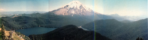
Panoramic view of Mounts St. Helens from Mount Margaret, about 9 miles north (Photograph [montage] by Maleah Taubman in August 1979).
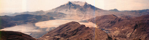
Mount St. Helens viewed from the same point after the May 18, 1980, eruption (Photograph [montage] by James Hughes in 1982).
Downwind of the volcano, in areas of thick ash accumulation, many agricultural crops, such as wheat, apples, potatoes, and alfalfa, were destroyed. Many crops survived, however, in areas blanketed by only a thin covering of ash. In fact, the apple and wheat production in 1980 was higher than normal due to greater-than-average summer precipitation. The crusting of ash also helped to retain soil moisture through the summer. Moreover, in the long term, the ash may provide beneficial chemical nutrients to the soils of eastern Washington, which themselves were formed of older glacial deposits that contain a significant ash component. Effects of the ash fall on the water quality of streams, lakes, and rivers were short-lived and minor.
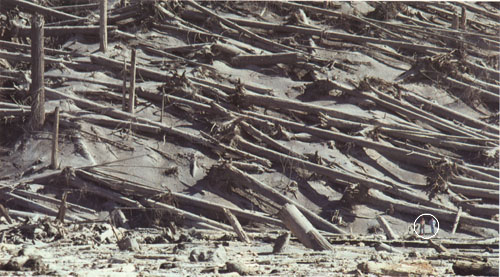
Stand of timber in the "tree-down" zone north of Mount St. Helens devastated by the lateral blast. The downed trees were salvaged as quickly as possible before the wood began to rot. Note the two people (circled) in lower right (Photograph by Lyn Topinka).
The ash fall, however, did pose some temporary major problems for transportation operations and for sewage-disposal and water-treatment systems. Because visibility was greatly decreased during the ash fall, many highways and roads were closed to traffic, some only for a few hours, but others for weeks. Interstate 90 from Seattle to Spokane, Washington, was closed for a week. Air transportation was disrupted for a few days to 2 weeks as several airports in eastern Washington shut down due to ash accumulation and attendant poor visibility. Over a thousand commercial flights were canceled following airport closures.
The fine-grained, gritty ash caused substantial problems for internal-combustion engines and other mechanical and electrical equipment. The ash contaminated oil systems, clogged air filters, and scratched moving surfaces. Fine ash caused short circuits in electrical transformers, which in turn caused power blackouts. The sewage-disposal systems of several municipalities that received about half an inch or more of ash, such as Moses Lake and Yakima, Washington, were plagued by ash clogging and damage to pumps, filters, and other equipment. Fortunately, as these same cities used deep wells and closed storage, their water-supply systems were only minimally affected.
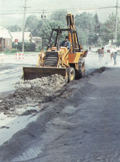
Front-end loader removing ash from Mount St. Helens as
part of the massive cleanup effort in eastern Washington (Copyrighted photograph
by Daryl Gusey).
The removal and disposal of ash from highways, roads, buildings, and airport runways were monumental tasks for some eastern Washington communities. State and Federal agencies estimated that over 2.4 million cubic yards of ash--equivalent to about 900,000 tons in weight--were removed from highways and airports in Washington State. Ash removal cost $2.2 million and took 10 weeks in Yakima. The need to remove ash quickly from transportation routes and civil works dictated the selection of some disposal sites. Some cities used old quarries and existing sanitary landfills; others created dumpsites wherever expedient. To minimize wind reworking of ash dumps, the surfaces of some disposal sites have been covered with topsoil and seeded with grass. About 250,000 cubic yards of ash have been stockpiled at five sites and can be retrieved easily for constructional or industrial use at some future date if economic factors are favorable.
What was the cost of the destruction and damage caused by the May 18 eruption? Accurate cost figures remain difficult to determine. Early estimates were too high and ranged from $2 to $3 billion, primarily reflecting the timber, civil works, and agricultural losses. A refined estimate of $1.1 billion was determined in a study by the International Trade Commission at the request of Congress. A supplemental appropriation of $951 million for disaster relief was voted by Congress, of which the largest share went to the Small Business Administration, U.S. Army Corps of Engineers, and the Federal Emergency Management Agency.
There were indirect and intangible costs of the eruption as well. Unemployment in the immediate region of Mount St. Helens rose tenfold in the weeks immediately following the eruption and then nearly returned to normal once timber salvaging and ash cleanup operations were underway. Only a small percentage of residents left the region because of lost jobs owing to the eruption. Several months after May 18, a few residents reported suffering stress and emotional problems, even though they had coped successfully during the crisis. The counties in the region requested funding for mental health programs to assist such people.
Initial public reaction to the May 18 eruption nearly dealt a crippling blow to tourism, an important industry in Washington. Not only was tourism down in the Mount St. Helens-Gifford Pinchot National Forest area, but conventions, meetings, and social gatherings also were canceled or postponed at cities and resorts elsewhere in Washington and neighboring Oregon not affected by the eruption. The negative impact on tourism and conventioneering, however, proved only temporary. Mount St. Helens, perhaps because of its eruptive activity, has regained its appeal for tourists. The U.S. Forest Service (USFS) and State of Washington opened visitor centers and provided access for people to view firsthand the volcano's awesome devastation.
The spectacular eruption impressed upon the people in the Pacific Northwest
that they share their lands with both active and potentially active volcanoes.
With the passage of time, the damaged forests, streams, and fields will
heal, and the memory of the 1980 eruption and its impacts will fade in future
generations. The Mount St. Helens experience has been so thoroughly documented,
however, that it likely will be a reminder for decades in the future of
the possibility of renewed volcanic activity and destruction.
Comparisons With Other Eruptions![]()

URL: <https://pubs.usgs.gov/gip/msh/impact.html>
Contact: John Watson
Last updated: 06.25.97