Volcanic debris flows--mobile mixtures of volcanic debris and water popularly called mudflows--often accompany pyroclastic eruptions, if water is available to erode and transport the loose pyroclastic deposits on the steep slopes of stratovolcanoes. Destructive mudflows and debris flows began within minutes of the onset of the May 18 eruption, as the hot pyroclastic materials in the debris avalanche, lateral blast, and ash falls melted snow and glacial ice on the upper slopes of Mount St. Helens. Such flows are also called lahars, a term borrowed from Indonesia, where volcanic eruptions have produced many such deposits.
Mudflows were observed as early as 8:50 a.m. PDT in the upper reaches of the South Fork of the Toutle River. The largest and most destructive mudflows, however, were those that developed several hours later in the North Fork of the Toutle River, when the water-saturated parts of the massive debris avalanche deposits began to slump and flow. The mudflows in the Toutle River drainage area ultimately dumped more than 65 million cubic yards of sediment along the lower Cowlitz and Columbia Rivers. The water-carrying capacity of the Cowlitz River was reduced by 85 percent, and the depth of the Columbia River navigational channel was decreased from 39 feet to less than 13 feet, disrupting river traffic and choking off ocean shipping. Mudflows also swept down the southeast flank of the volcano--along the Swift Creek, Pine Creek, and Muddy River drainages--and emptied nearly 18 million cubic yards of water, mud, and debris into the Swift Reservoir. The water level of the reservoir had been purposely kept low as a precaution to minimize the possibility that the reservoir could be overtopped by the additional water-mud-debris load to cause flooding of the valley downstream. Fortunately, the volume of the additional load was insufficient to cause overtopping even if the reservoir had been full.
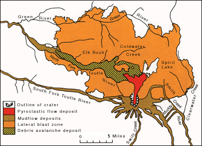
Generalized geologic map showing the impact and deposits of the climactic eruption in the vicinity of the volcano.
On the upper steep slopes of the volcano, the mudflows traveled as fast as 90 miles an hour; the velocity then progressively slowed to about 3 miles an hour as the flows encountered the flatter and wider parts of the Toutle River drainage. Even after traveling many tens of miles from the volcano and mixing with cold waters, the mudflows maintained temperatures in the range of about 84° to 91°F.; they undoubtedly had higher temperatures closer to the eruption source. Shortly before 3 p.m., the mud and debris-choked Toutle River crested about 21 feet above normal at a point just south of the confluence of the North and South Forks. Another stream gage at Castle Rock, about 3 miles downstream from where the Toutle joins the Cowlitz, indicated a high-water (and mud) mark also about 20 feet above normal at midnight of May 18. Locally the mudflows surged up the valley walls as much as 360 feet and over hills as high as 250 feet. From the evidence left by the "bathtub-ring" mudlines, the larger mudflows at their peak averaged from 33 to 66 feet deep. The actual deposits left behind after the passage of the mudflow crests, however, were considerably thinner, commonly less than 10 percent of their depth during peak flow. For example, the mudflow deposits along much of the Toutle River averaged less than 3 feet thick.
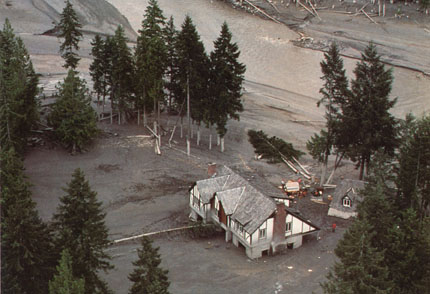
Mudflow-damaged house along the Toutle River. The height of the mudflow is shown by the "bathtub-ring" mudlines seen on the tree trunks and the house itself (Photograph by Dwight Crandell).
URL: <https://pubs.usgs.gov/gip/msh/mudflows.html>
Contact: John Watson
Last updated: 06.25.97
