|
1
|
Argillite and metagraywacke are the two major bedrock types. Look across Highway 64. Can you see these two rock types? One is black and the other dark gray. These rocks formed 750 million years ago, which is equal to 15 million human lifetimes.
|
|
2
|
In the river bed, the higher ledges are the metagraywacke; the lower troughs are the argillite. The argillite is softer and more easily eroded, leaving the harder meta-graywacke protruding to make a whitewater channel. Now look for the artificial rocks. They connect the levee to the channel; they extend existing rock higher or sit in the middle of the channel to divert water in a particular direction. They were installed to make better whitewater.
|
|
3
|
The marble veins in the terraces resemble the quartz veins in the metagraywacke. Look downstream for rocks with quartz veins. Look at the outcrops on the slope across the river. Note the metagraywacke outcrop that extends from the mountaintop down to and across the river.
|
|
4
|
The color in the sandstone terrace paving varies, but the sandstone is all from the same formation.
|
|
5
|
If you take the Old Copper Road Trail, remember the mineral resources of the Copper Basin. The mining and processing of ore there greatly changed the Ocoee River and the region.
|
|
6
|
Potholes are smooth bowl-shaped holes in the rock carved out by swirling gravel in river eddies. In the river rock below, how many potholes do you see? (If the water is up, probably not many.) Next look upstream and downstream. Compare the constructed river channel with the unconstructed channel.
|
|
|
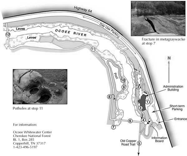
7
|
At the end of the walk is a massive boulder of metagraywacke. Note its coarse-grained texture and the large fracture that cuts it.
|
|
8
|
The steps to the river are made from the same sandstone boulders as used on the levee. The retaining wall along the path is also sandstone. Seep holes in the wall allow the ground water to escape from behind the wall.
|
|
9
|
A bedrock outcrop of black argillite is in the upstream end of the pool. How is it different from the metagraywacke?
|
|
10
|
This argillite contains pyrite (look for small, gold-colored cubes). The pyrite oxidizes to produce the rusty color on the river rocks. This stain is easily seen on the concrete sidewalks. Weathered pyrite contributes to the high acidity in the Ocoee River.
|
|
11
|
Two great examples of potholes can be seen here. The potholes are in metagraywacke beside the walkway.
|
|
12
|
Now can you pick out the artificial rock? Look upstream and downstream. Compare the constructed channel with the unconstructed river.
Walk back along the levee on the other side of the river. Look at the levee and the highway embankment.
Can you find the large argillite outcrop between the sidewalk and the highway embankment? Do you spy more artificial rock features? Are you sure? Look for signs of past floods. Or don't think about anything and just enjoy.
|
|