Many of our natural parks are defined by their spectacular geology, such as the landforms of the Grand Canyon and the magnificent fossils in Dinosaur National Monument. Some show just how dynamic geology is, like the geysers in Yellowstone National Park. To help park staff understand and manage these resources, the National Park Services invites people to work for several months as geologists in the parks. Some positions are paid, and others are volunteer.
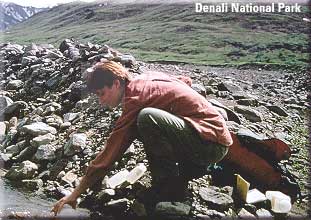
Sara Schlichtholz collects a water sample at one of the park's streams.
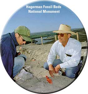
Bob Lorkowski (right) and another park geologist discuss a fossil of the Hagerman Horse, a zebra-like ancestor of today's horse.
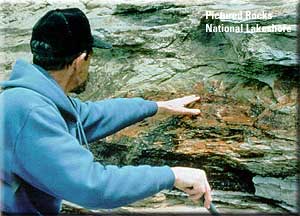
Bob Rosé examines mineral stains on a cliff face at the park.
Jessica Cundiff records information for a map of the park's geologic resources. |
Being a geologist in the parks is a great way for new earth scientists, like many of the people featured here, to get hands-on experience. Jessica Cundiff, while an undergraduate geology major at Southwest Missouri State University, earned college credits for her work at Guadalupe Mountains National Park in Texas. The park contains parts of one of the Earth's largest fossil reefs. The reef formed approximately 250 million years ago when a tropical ocean covered parts of what is now Texas and New Mexico. Cundiff researched and wrote two pamphlets about the geology of the park. She also helped gather information for a road guide to the park's geology. Catherine Impasto used her earth science degree from Dartmouth College to create exhibits and teaching materials about the geology of Haleakala National Park. Located on the Hawaiian island of Maui, the park is famous for its volcanic landscape filled with lava flows and cinder cones. Haleakala last erupted in 1790, but as Impasto explains, "Most people think that Haleakala is dormant and probably won't erupt anytime soon. But they're probably wrong." One of the displays that Impasto produced shows visitors what past eruptions of Haleakala looked like and what geologists believe future eruptions might look like. Bob Lorkowski is usually teaching high school physics, chemistry, and earth science, but has recently spent several summers doing field work at Hagerman Fossil Beds National Monument in Idaho. The park is most famous for its fossils buried in cliffs that rise 600 feet above the Snake River. Lorkowski, who has a master's degree in geology, has been studying and making maps of six of the cliff's rock layers. Lorkowski does his field work in the park over a month-long period. He then returns to his home in California to analyze rock samples under the microscope and to write his reports. He anticipates that his research will require a total of six summers before he completes it. Johanna Lombard was a volunteer at Sunset Crater Volcano National Monument near Flagstaff, Ariz. While a volunteer, she designed a previsit information packet for teachers. The packet covers seismology (the study of earthquakes), volcanology (the study of volcanoes), and plate tectonics — topics teachers will use to explain how the park's volcano, Sunset Crater, formed. Bob Rosé, a retired petroleum geologist, brought a great deal of experience to Pictured Rocks National Lakeshore, located on the shore of Lake Superior. The park gets its name from a wall of rock that has been sculpted into caves and from arches that look like castles and fortresses. From looking at the park's geology and reading about it in the scientific literature, Rosé sketched what the park would have looked like 500 million years ago. His findings were so intriguing that the park asked Rosé to help design major changes to the displays in the visitors center. Rosé says, "The time I spent in the park was one of the best experiences of my life!" Sara Schlichtholz, a recent geology graduate from the University of Montana, created a database of the fossils in Alaska's Denali National Park. Schlichtholz explains, "Basically, I sorted through close to 40 years of documents to squeeze out information on what fossils occur in the park and where they occur." She organized more than 800 records and plotted more than 200 localities on a park map. Now researchers needing information on the park's fossils can find it quickly. Schlichtholz, however, did not spend all her time at the computer. "You can only spend so much time behind a computer when one is in Denali! I jumped onto whatever project had room for me. I helped gather hydrologic data from streams and installed survey markers around a glacier," she remarks. You can reach the Geologist in the Parks program at www2.nature.nps.gov/grd/geojob/index.htm.
Johnna Lombard helps out in the Sunset Crater Volcano National Monument visitors center.
Catherine Impasto sorts volcanic rocks for a "Rock Box" she designed for local teachers to show to students before they visit Haleakala National Park. |
|| Back to the top || Back to Scientists in Action Front Page ||
[an error occurred while processing this directive]
[an error occurred while processing this directive]