USGS logo

Scientists React!

|| Floods || Volcanic Eruptions ||

How Often Does a 100-Year Flood Happen?
Unfortunately, the term" 100-year flood" is misleading because it leads people to believe that the flood happens only once every 100 years. The term "100-year flood" is a statistical designation, and there is a 1-in-100 chance that a flood this size will happen during any year. Sometimes we get big floods in successive or nearly successive years.

A color photograph of a man hanging from a cable harness over a stream of water, photo: Randy Hayes, Idaho Falls, Idaho

A hydrologic technician hangs from a cableway to make stream measurements.


A color photograph of a biking crossing sign with water up to the base of the sign.

Every year, rivers flood in many different parts of the country.

Floods
California
Winter 1998

The first 2 months of 1998 were the wettest on record for the continental United States. California was particularly hard hit. As heavy rains pounded the northern and central parts of the State, U.S. Geological Survey (USGS) technicians hurried to swollen streams to measure streamflows and to determine how much more water streams can handle. Collecting measurements can be risky as technicians lean precariously over bridges or hang from small cable cars suspended above swollen streams. According to USGS hydrologic technician William Boults, "You are about 15 feet above the raging waters in a cable car with a 100-pound weight, your feet dangle over the water . . . it can get scary."

When a flood threatens, field technicians are the critical link in getting accurate information to flood forecasters so that they can estimate the timing and size of the flood. To make their calculations, flood forecasters need to know two things about a river: the river stage (the height of the water) and the river discharge (the volume of the flow of water as it moves past a fixed point in a given time period). The stage is measured continuously at a stream-gaging station located on the river. More than half of the Nation's gaging stations are equipped with satellite radios that transmit river stage data every 4 hours to the USGS, the National Weather Service, and other agencies. Extremely high water triggers instantaneous emergency transmissions.

River discharge is more difficult to measure than river stage. To determine discharge, hydrologists, scientists who study the Earth's water systems, need to know how much water the stream's channel can carry. The capacity of the stream channel can change, so streams must be measured often, especially during high flow periods when the channel is most apt to change. During periods of high flow, field crews must go to stream-gaging stations to measure the river discharge.

Although Boults and other hydrologic technicians spend a great deal of time in the field, they probably spend more time in their offices compiling and summarizing data, which are interpreted by hydrologists. To do their work, hydrologic technicians use computers and sophisticated electronics, including data logging and recording systems, satellite radios, and global positioning systems (GPS). A college degree is not required to become a hydrologic technician, although many technicians have at least a 2-year technical degree.

Volcanic Eruption
Mount Pinatubo
June 15, 1991

The eruption of Mount Pinatubo in the Philippines on June 15, 1991, was one of the largest volcanic eruptions in the 20th century. It could have killed or injured tens of thousands of people, but fortunately the eruption injured fewer than 500. About 1 million people, including some 20,000 American military personnel and their families at two U.S. military bases, lived near the volcano. Because volcanologists with the Philippine Institute of Volcanology and Seismology and the U.S. Geological Survey (USGS) forecasted the eruption, civil and military leaders were able to evacuate people in time, saving thousands of lives.

John Ewert was among the 23 USGS scientists and electronics and computer specialists on the joint Philippine-American team. One of Ewert's responsibilities was to install telemetered tiltmeters on the volcano. These instruments transmitted data to the scientists headquartered at Clark Air Force Base so that they could monitor changes in the volcano's shape. Ewert explained that as magma rises in a volcano, it changes, or deforms, the volcano's shape.

When asked what type of scientist he is, Ewert responded, "I guess I am a geologist. No, I guess I am a volcanologist." He further explained that volcanology is "highly interdisciplinary." It includes geochemistry, stratigraphy (layers of rocks), geophysics, and the subdisciplines of geophysics such as seismology (movements in the Earth's crust). "And there are lots of things we do that require a facility with electronics — from knowing how to solder two wires together to troubleshooting circuitry."

Ewert has an undergraduate degree in geology and has completed 2 years of graduate study. "Experience," he explains, "is kind of how I got into what I am doing. I finished my undergraduate degree in 1980 when Mount St. Helens erupted, and I was hired several months later. Over a period of 4 years I did everything from airborne gas monitoring, to deformation studies of the volcano's crater, to hydrologic monitoring of the streams around the volcano. There is really no substitute for that kind of experience. You don't go to a university and major in erupting volcanoes."

Rick Hoblitt, another member of the team, was an organic chemist before he earned a doctorate in geology. As part of the team at Mount Pinatubo, Hoblitt examined and mapped deposits left by past eruptions to anticipate what types of eruptions were likely to happen and the areas that were likely to be affected. "Really what I see as my chief role in these crises is data synthesis, interpretation, and then communication of that synthesis."

With the information they collected, Rick Hoblitt, John Ewert, and other scientists were responsible for predicting if a catastrophic eruption would occur and when an evacuation should be ordered. The stress was intense. More than 10 days before the major eruption, Hoblitt wrote in his diary, "Activity at vent is up. More ash is coming up, some puffs to 1,000 feet above the summit. Dave, Andy, John, and I discuss the situation after breakfast. We're not sleeping well because of nerves. Is it possible that a catastrophic eruption could occur with no warning? I think that this is possible. Depressing subject." Hoblitt was afraid that they wouldn't be able to forecast an eruption in time to save lives. Fortunately their timing was correct.

More information on natural hazards is on the USGS Web site at www.usgs.gov/hazards.


A color photograph of Mt. Pinatubo after major eruption, photo: Ed Wolfe,USGS/CVO

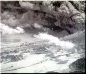
Mount Pinatubo after its major eruption on June 15, 1991


A color photograph of a cloud of ash and smoke from a volcanoe, photo: J.N. Marso, USGS/CVO

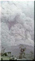
Plume from a smaller eruption, July 1991.

|| Back to the top || Scientists React! Contents || Back to Scientists in Action Front Page ||

[an error occurred while processing this directive]

[an error occurred while processing this directive]