Earthquake
Northridge, California January 17, 1994
At 4:31 a.m. on January 17, 1994, some 10 million people were shaken awake by an earthquake. The
Northridge earthquake collapsed buildings, ruptured gas lines, and toppled freeways. The 6.7 magnitude
quake killed 57 people, injured more than 9,000, and displaced more than 20,000 people from their
homes.
Within minutes of the main shock, earthquake scientists were analyzing data and dispatching
information about the quake to emergency response agencies. "When I felt the earthquake, I jumped out of
bed, threw on clothes, and came in. When you feel an earthquake, you run in," recalls Lucy Jones, a
seismologist at the U.S. Geological Survey (USGS). Jones is Chief of the USGS field office in Pasadena,
Calif., the office that operates the network of seismic instruments that monitors earthquakes in southern
California. Seismic instruments detect, measure, and record the vibrations that travel through the Earth and
over its surface when an earthquake happens.
"I spent the whole day in what we call the operations center dealing with a variety of tasks," Jones
explains. "One was talking to the media. And one was tracking aftershocks." Smaller earthquakes called
aftershocks, which also can cause damage, especially to buildings and other structures weakened by the initial
shock, usually follow a major earthquake. Jones, an expert in earthquake statistics, estimated the probability
of damaging aftershocks and where they would most likely occur.
This information was of vital importance to emergency service agencies that were coordinating and
dispatching response teams.
Many other scientists quickly began collecting and analyzing data to learn how to
reduce hazards from future earthquakes. It is unfortunately true that the best laboratory for studying
earthquakes is an actual earthquake.
Daniel Ponti is a USGS geologist who studies the surface effects of earthquakes. On the day after
the earthquake, Ponti recalls, "I spent most of the day in a helicopter doing reconnaissance work from the air."
He was looking for where, or if, the fault — the fracture in the Earth's crust that caused the earthquake
— had ruptured the surface. When a large fault ruptures and produces an earthquake, it usually causes
ground cracks that displace the foundations of buildings, fracture swimming pools, and rupture water and gas
pipelines. Knowing where the greatest damage was concentrated could help Ponti and his team of geologists
locate the fault.
Ultimately, Ponti and other scientists determined that the earthquake was caused by a hidden fault,
called a blind thrust fault, which did not rupture the surface. The minor ground cracks were caused by
shaking produced by the earthquake. Ponti and his team also dug trenches in the areas where the greatest
damage occurred and looked for evidence of past earthquakes. Their investigation uncovered cracks left by
two earthquakes that occurred during the past 1,300 years. Because these cracks were remarkably similar to
the surface cracks caused by the Northridge earthquake, the geologists concluded that the two older
earthquakes most likely occurred on blind faults as well. This information is helping geologists locate other
blind faults as they study the region's earthquake history, which will improve their ability to forecast where
future earthquakes might strike.
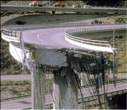
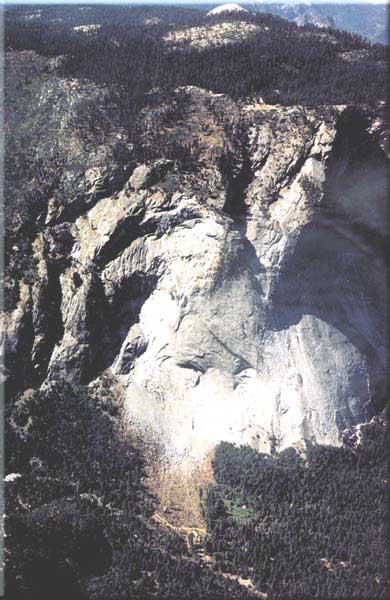
Collapsed
freeways symbolized the Northridge earthquake more than any other type of damage.
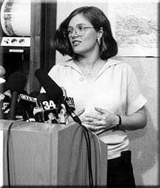
Seismologist Lucy Jones fields questions from the press about an earthquake that struck
Landers, Calif. in 1992.
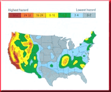
As this map shows, California is not the only place at risk from earthquake damage.
Architects, engineers, and land use planners throughout the country use these maps to assess earthquake risks
when planning buildings and other structures.
|