|
1 Name: Zero Milestone Location: Ellipse, north edge Building Stone: Milford, Mass., granite Remarks: The Zero Milestone is a substitute marker for a column planned by Pierre L'Enfant. The column was to be placed 1 mile east of the Capitol, "from which all distances of places through the continent were to be calculated." Today's marker provides a point from which distances may be measured on U.S. highways that radiate from Washington. |

|
|
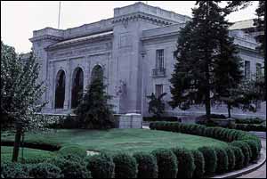
2 Name: Organization of American States (Pan American Union Building) Location: 17th Street and Constitution Avenue NW Building Stones: Exterior, Georgia marble; steps and foundation, Tennessee marble (two types); steps at rear of patio, green Italian marble Remarks: The building was designed to blend the architectural styles of North and South America by combining Aztec, Incan, Mayan, and European themes and motifs. Construction was begun May 11, 1908, and the building was dedicated April 26, 1910. |
|
|
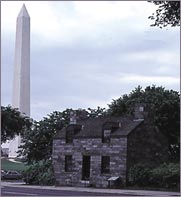
3 Name: Lock House Location: 17th Street and Constitution Avenue NW Building Stone: Crystalline metamorphic rocks, Piedmont of Maryland Remarks: The site of Lock House was once the western end of the Washington City Canal, where Tiber Creek emptied into the Potomac River. The structure was built in 1833 when the extension of the C&O Canal was completed and joined the two canals. |
|
|
4 Name: Haupt Fountains Location: The Ellipse at Constitution Avenue NW Building Stone: Granite-gneiss, Minnesota Remarks: These fountains, built in 1967, clearly show the structure of the original rock; note the large, light-red crystals of the mineral feldspar. The fountains were constructed from blocks of the oldest rock in the United States‚3.5 billion years old. |

|
|
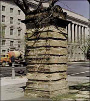
5 Name: Gateposts Location: Southeast and northwest corners of 15th Street and Constitution Avenue NW and southwest corner of 14th Street and Constitution Avenue Building Stone: Aquia Creek sandstone, Virginia Remarks: These posts, originally at the Capitol, were constructed about 1829. On the post on the northwest corner of 15th Street and Constitution Avenue NW, two lines chiseled into the stone about 3 feet from the bottom indicate the heights of flooding of the Potomac River in the 1930's and 1940's. |
|
|
6 Name: Commerce Department Building Location: 14th Street between E Street and Constitution Avenue NW Building Stones: Exterior, first and second floors, Stony Creek granite, Connecticut; interior, Georgia and Missouri marble Remarks: The heights of buildings in Washington are restricted by the Federal Height Act of 1910, to avoid obstructing the view of landmarks like the Capitol and the Washington Monument. Instead of the skyscrapers found in most modern cities, most of Washington's large office buildings spread out to cover a city block or more. |

|
This page is https://pubs.usgs.gov/stones/stops1-6.html
Maintained by Publications Services
Last revised 1-14-99 (krw)