It has been said that the science of "volcanology" originated
with the accurate descriptions of the eruption of Vesuvius in A.D. 79 contained
in two letters from Pliny the Younger to the Roman historian Tacitus. Pliny's
letters also described the death of his uncle, Pliny the Elder, who was
killed in the eruption. Actually, however, it was not until the 19th century
that serious scientific inquiry into volcanic phenomena flourished as part
of the general revolution in the physical and life sciences, including the
new science of "geology." In 1847, an observatory was established
on the flanks of Vesuvius, upslope from the site of Herculaneum, for the
more or less continuous recording of the activity of the volcano that destroyed
the city in A.D. 79. Still, through the first decade of the 20th century,
the study of volcanoes by and large continued to be of an expeditionary
nature, generally undertaken after the eruption had begun or the activity
had ceased.
Perhaps "modern" volcanology began in 1912, when Thomas A. Jaggar, Head of the Geology Department of the Massachusetts Institute of Technology, founded the Hawaiian Volcano Observatory (HVO), located on the rim of Kilauea's caldera. Initially supported by an association of Honolulu businessmen, HVO began to conduct systematic and continuous monitoring of seismic activity preceding, accompanying, and following eruptions, as well as a wide variety of other geological, geophysical, and geochemical observations and investigations. Between 1919 and 1948, HVO was administered by various Federal agencies (National Weather Service, U.S. Geological Survey, and National Park Service), and since 1948 it has been operated continuously by the Geological Survey as part of its Volcano Hazards Program. The more than 75 years of comprehensive investigations by HVO and other scientists in Hawaii have added substantially to our understanding of the eruptive mechanisms of Kilauea and Mauna Loa, two of the world's most active volcanoes. Moreover, the Hawaiian Volcano Observatory pioneered and refined most of the commonly used volcano-monitoring techniques presently employed by other observatories monitoring active volcanoes elsewhere, principally in Indonesia, Italy, Japan, Latin America, New Zealand, Lesser Antilles (Caribbean), Philippines, and Kamchatka (U .S.S.R.).
|
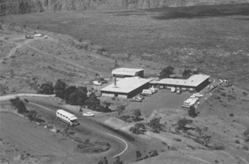
The U.S. Geological Survey's Hawaiian Volcano Observatory, on the crater rim of Kilauea Volcano. |
What does "volcano monitoring" actually involve? Basically, it is the keeping of a detailed "diary" of the changes--visible and invisible--in a volcano and its surroundings. Between eruptions, visible changes of importance to the scientists would include marked increase or decrease of steaming from known vents; emergence of new steaming areas; development of new ground cracks or widening of old ones; unusual or inexplicable withering of plant life; changes in the color of mineral deposits encrusting fumaroles; and any other directly observable, and often measurable, feature that might reflect a change in the state of the volcano. Of course, the "diary" keeping during eruptive activity presents additional tasks. Wherever and whenever they can do so safely, scientists document, in words and on film, the course of the eruption in detail; make temperature measurements of lava and gas; collect the eruptive products and gases for subsequent laboratory analysis; measure the heights of lava fountains or ash plumes; gage the flow rate of ash ejection or lava flows; and carry out other necessary observations and measurements to fully document and characterize the eruption. For each eruption, such documentation and data collection and analysis provide another building block in constructing a model of the characteristic behavior of a given volcano or type of eruption.
Volcano monitoring also involves the recording and analysis of volcanic phenomena not visible to the human eye, but measurable by precise and sophisticated instruments. These phenomena include ground movements, earthquakes (particularly those too small to be felt by people), variations in gas compositions, and deviations in local electrical and magnetic fields that respond to pressure and stresses caused by the subterranean magma movements.
Some common methods used to study invisible, volcano-related phenomena are based on:
Recording historic eruptions and modern volcano-monitoring in themselves are insufficient to fully determine the characteristic behavior of a volcano, because a time record of such information, though perhaps long in human terms, is much too short in geologic terms to permit reliable predictions of possible future behavior. A comprehensive investigation of any volcano must also include the careful, systematic mapping of the nature, volume, and distribution of the products of prehistoric eruptions, as well as the determination of their ages by modern isotopic and other dating methods. Research on the volcano's geologic past extends the data base for refined estimates of the recurrence intervals of active versus dormant periods in the history of the volcano. With such information in hand, scientists can construct so-called "volcanic hazards" maps that delineate the zones of greatest risk around the volcano and that designate which zones are particularly susceptible to certain types of volcanic hazards (lava flows, ash fall, toxic gases, mudflows and associated flooding, etc.).
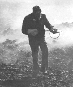
|
Scientist, wearing asbestos gloves and gas mask, samples volcanic gases from active vent. |
A strikingly successful example of volcano research and volcanic hazard assessment was the 1978 publication (Bulletin 1383-C) by two Geological Survey scientists, Dwight Crandell and Donal Mullineaux, who concluded that Mount St. Helens was the Cascade volcano most frequently active in the past 4,500 years and the one most likely to reawaken to erupt, "...perhaps before the end of this century." Their prediction came true when Mount St. Helens rumbled back to life in March of 1980. Intermittent explosions of ash and steam and periodic formation of short-lived lava domes continued throughout the decade. Analysis of the volcano's past behavior indicates that this kind of eruptive activity may continue for years or decades, but another catastrophic eruption like that of May 18, 1980, is unlikely to occur soon.
On 18 May 1982, the U.S. Geological Survey (USGS) formally dedicated the David A. Johnston Cascades Volcano Observatory (CVO) in Vancouver, Washington, in memory of the Survey volcanologist killed two years earlier. This facility--a sister observatory to the Hawaiian Volcano Observatory-- facilitates the increased monitoring and research on not only Mount St. Helens but also the other volcanoes of the Cascade Range of the Pacific Northwest. More recently, in cooperation with the State of Alaska, the USGS established the Alaska Volcano Observatory in March 1988. The work being done at these volcano observatories provides important comparisons and contrasts between the behavior of the generally non-explosive Hawaiian shield volcanoes and that of the generally explosive composite volcanoes of the Cascade and Alaskan Peninsula-Aleutian chains.
[ Previous ] [ Table of Contents ] [ Next ]