According to the now generally accepted "plate-tectonics" theory,
scientists believe that the Earth's surface is broken into a number of shifting
slabs or plates, which average about 50 miles in thickness. These plates
move relative to one another above a hotter, deeper, more mobile zone at
average rates as great as a few inches per year. Most of the world's active
volcanoes are located along or near the boundaries between shifting plates
and are called "plate-boundary" volcanoes. However, some active
volcanoes are not associated with plate boundaries, and many of these so-called
"intra-plate" volcanoes form roughly linear chains in the interior
of some oceanic plates. The Hawaiian Islands provide perhaps the best example
of an "intra-plate" volcanic chain, developed by the northwest-moving
Pacific plate passing over an inferred "hot spot" that initiates
the magma-generation and volcano formation process. The peripheral areas
of the Pacific Ocean Basin, containing the boundaries of several plates,
are dotted by many active volcanoes that form the so-called "Ring of
Fire." The "Ring" provides excellent examples of "plate
boundary" volcanoes, including Mount St. Helens.
The accompanying figure shows the boundaries of lithosphere plates that are presently active. The double lines indicate zones of spreading from which plates are moving apart. The lines with barbs show zones of underthrusting (subduction), where one plate is sliding beneath another. The barbs on the lines indicate the overriding plate. The single line defines a strike-slip fault along which plates are sliding horizontally past one another. The stippled areas indicate a part of a continent, exclusive of that along a plate boundary, which is undergoing active extensional, compressional, or strike-slip faulting.
|
|
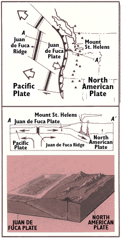
In the Pacific Northwest, the Juan de Fuca Plate plunges beneath the North American Plate, locally melting at depth; the magma rises to feed and form the Cascade volcanoes. The area at the top of this figure is the area highlighted in red at the right. |
Click on thumbnail image for map showing the major tectonic plates of the Earth. |
[ Previous ] [ Table of Contents ] [ Next ]