GROUND WATER ATLAS of the UNITED STATES
Introduction and National Summary
Carbonate-rock aquifers
There are two different files for each illustration
- A 72 ppi GIF file, suitable for screen viewing is accessed
through the thumbnail image.
- An eps file, suitable for downloading to be printed or edited
is accessed through the "eps file" link. Most files
are Adobe Illustrator 6.0, exceptions are noted. These files
have been compressed with GNU's gzip utility. If your web browser
defaults to a screen display of the file, turn on the "Load
to local disk" option before downloading. Download and process
these eps files as ascii, not binary.
Carbonate-rock aquifers
Figure 27 Photograph showing carbonate-rocks with extremely
permeable conduits that conduct large volumes of water (44K)
 This illustration contains a placed image. Download the Adobe Illustrator
6 eps file A027.eps.gz (6.8M compressed)
which contains an imbedded Adobe Photoshop 3 (eps) file. You may also want
to download the editable Photoshop
file A027ph.eps.gz (6.7M compressed)
This illustration contains a placed image. Download the Adobe Illustrator
6 eps file A027.eps.gz (6.8M compressed)
which contains an imbedded Adobe Photoshop 3 (eps) file. You may also want
to download the editable Photoshop
file A027ph.eps.gz (6.7M compressed)
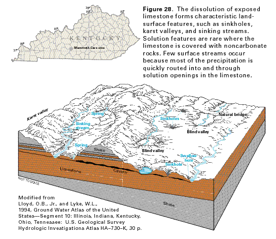
Figure 28 Diagrammatic section showing common
types of karst features that develop on the land surface where
limestone is exposed in the Mammoth Cave area of central Kentucky
(36K)
 This illustration contains a placed image. Download the Adobe Illustrator
6 eps file A028.eps.gz (256K compressed)
which contains an imbedded Adobe Photoshop 3 (eps) file. You may also want
to download the editable Photoshop
file A028ph.eps.gz (160K compressed)
This illustration contains a placed image. Download the Adobe Illustrator
6 eps file A028.eps.gz (256K compressed)
which contains an imbedded Adobe Photoshop 3 (eps) file. You may also want
to download the editable Photoshop
file A028ph.eps.gz (160K compressed)
Figure 29 Photograph showing an underground stream
in the Mammoth Cave system (60K)
 This illustration contains a placed image. Download the Adobe Illustrator
6 eps file A029.eps.gz (8.4M compressed)
which contains an imbedded Adobe Photoshop 3 (eps) file. You may also want
to download the editable Photoshop
file A029ph.eps.gz (8.4M compressed)
This illustration contains a placed image. Download the Adobe Illustrator
6 eps file A029.eps.gz (8.4M compressed)
which contains an imbedded Adobe Photoshop 3 (eps) file. You may also want
to download the editable Photoshop
file A029ph.eps.gz (8.4M compressed)
Figure 30 Map showing the location of the
Floridan aquifer system (28K)
 editable eps file A030.eps.gz
(328K compressed)
editable eps file A030.eps.gz
(328K compressed)
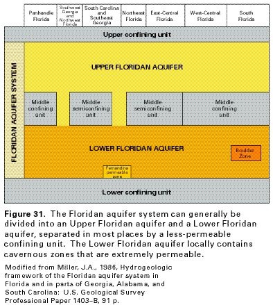
Figure 31 Correlation chart showing the composition
of the Floridan aquifer system (20K)
 editable eps file A031.eps.gz
(16K compressed)
editable eps file A031.eps.gz
(16K compressed)
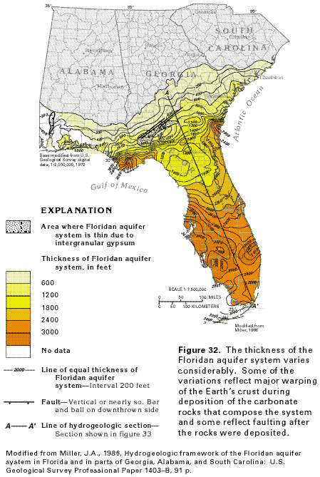
Figure 32 Map showing the variation of thickness
of the Floridan aquifer system (48K)
 editable eps file A032.eps.gz
(436K compressed)
editable eps file A032.eps.gz
(436K compressed)
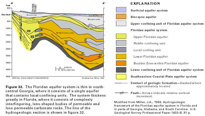
Figure 33 Cross section showing the composition
of the Floridan aquifer system at the border between Georgia and
Florida (32K)
 editable eps file A033.eps.gz
(56K compressed)
editable eps file A033.eps.gz
(56K compressed)
Figure 34 Map showing the movement of water
through the Upper Floridan aquifer (60K)
 editable eps file A034.eps.gz
(236K compressed)
editable eps file A034.eps.gz
(236K compressed)
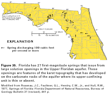
Figure 35 Map showing the location of the first-magnitude
springs issuing from the Upper Floridan aquifer (24K)
 editable eps file A035.eps.gz
(120K compressed)
editable eps file A035.eps.gz
(120K compressed)
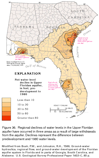
Figure 36 Map showing regional declines
of water levels in the Upper Floridan aquifer (36K)
 editable eps file A036.eps.gz
(340K compressed)
editable eps file A036.eps.gz
(340K compressed)
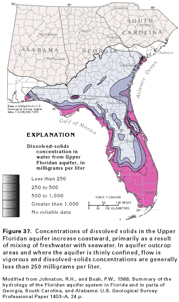
Figure 37 Map showing concentrations of
dissolved solids in the Upper Floridan aquifer (36K)
 editable eps file A037.eps.gz
(380K compressed)
editable eps file A037.eps.gz
(380K compressed)
 This illustration contains a placed image. Download the Adobe Illustrator
6 eps file A027.eps.gz (6.8M compressed)
which contains an imbedded Adobe Photoshop 3 (eps) file. You may also want
to download the editable Photoshop
file A027ph.eps.gz (6.7M compressed)
This illustration contains a placed image. Download the Adobe Illustrator
6 eps file A027.eps.gz (6.8M compressed)
which contains an imbedded Adobe Photoshop 3 (eps) file. You may also want
to download the editable Photoshop
file A027ph.eps.gz (6.7M compressed)