GROUND WATER ATLAS of the UNITED STATES
Introduction and National Summary
Sandstone and carbonate-rock aquifers
There are two different files for each illustration
- A 72 ppi GIF file, suitable for screen viewing is accessed
through the thumbnail image.
- An eps file, suitable for downloading to be printed or edited
is accessed through the "eps file" link. Most files
are Adobe Illustrator 6.0, exceptions are noted. These files
have been compressed with GNU's gzip utility. If your web browser
defaults to a screen display of the file, turn on the "Load
to local disk" option before downloading. Download and process
these eps files as ascii, not binary.
Sandstone and carbonate-rock aquifers
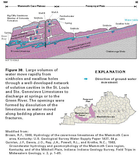
Figure 38 Cross section showing the movement of water through
the unconfined and confined parts of the limestone aquifers that
underlie the Pennyroyal Plain and Mammoth Cave Plateau (36K)
 editable eps file A038.eps.gz
(168K compressed)
editable eps file A038.eps.gz
(168K compressed)
Figure 39 Graphs comparing the recharge
rate of wells completed in sandstone and carbonate-rock aquifers
(24K)
 editable eps file A039.eps.gz
(16K compressed)
editable eps file A039.eps.gz
(16K compressed)
 editable eps file A038.eps.gz
(168K compressed)
editable eps file A038.eps.gz
(168K compressed) 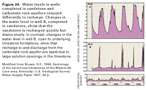 editable eps file A039.eps.gz
(16K compressed)
editable eps file A039.eps.gz
(16K compressed)