GROUND WATER ATLAS of the UNITED STATES
Introduction and National Summary
Unconsolidated sand and gravel aquifers
There are two different files for each illustration
- A 72 ppi GIF file, suitable for screen viewing is accessed
through the thumbnail image.
- An eps file, suitable for downloading to be printed or edited
is accessed through the "eps file" link. Most files
are Adobe Illustrator 6.0, exceptions are noted. These files
have been compressed with GNU's gzip utility. If your web browser
defaults to a screen display of the file, turn on the "Load
to local disk" option before downloading. Download and process
these eps files as ascii, not binary.
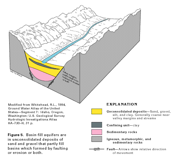
Basin-fill aquifers
Figure 5 Diagrammatic section showing the structure
of basin-fill aquifers (24K)
 This illustration contains a placed image. Download the Adobe Illustrator
6 eps file A005.eps.gz (56K compressed)
which contains an imbedded Adobe Photoshop 3 (eps) file. You may also want
to download the editable Photoshop
file A005ph.eps.gz (32K compressed)
This illustration contains a placed image. Download the Adobe Illustrator
6 eps file A005.eps.gz (56K compressed)
which contains an imbedded Adobe Photoshop 3 (eps) file. You may also want
to download the editable Photoshop
file A005ph.eps.gz (32K compressed)
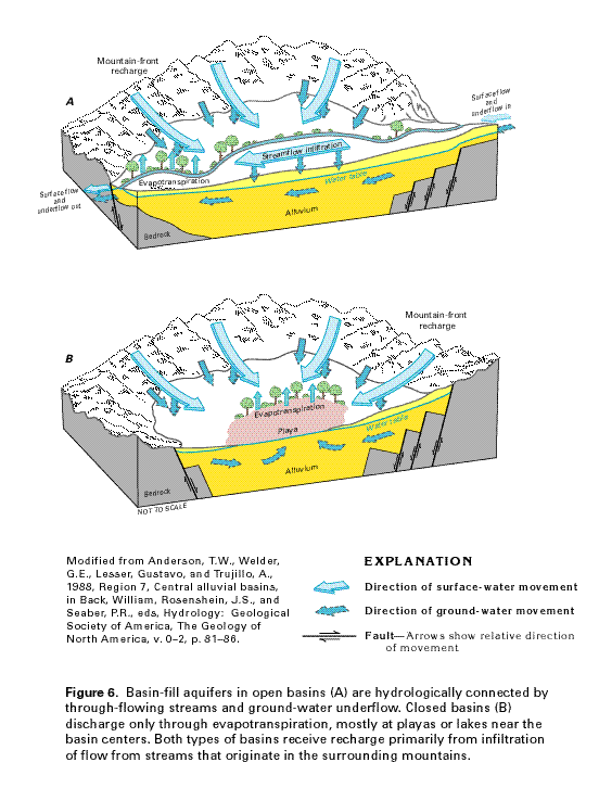
Figure 6 Diagrammatic section showing flow
through open and closed basin-fill aquifers (40K)
 This illustration contains a placed image. Download the Adobe Illustrator
6 eps file A006.eps.gz (176K compressed)
which contains an imbedded Adobe Photoshop 3 (eps) file. You may also want
to download the editable Photoshop
file A006ph.eps.gz (52K compressed)
This illustration contains a placed image. Download the Adobe Illustrator
6 eps file A006.eps.gz (176K compressed)
which contains an imbedded Adobe Photoshop 3 (eps) file. You may also want
to download the editable Photoshop
file A006ph.eps.gz (52K compressed)
 This illustration contains a placed image. Download the Adobe Illustrator
6 eps file A005.eps.gz (56K compressed)
which contains an imbedded Adobe Photoshop 3 (eps) file. You may also want
to download the editable Photoshop
file A005ph.eps.gz (32K compressed)
This illustration contains a placed image. Download the Adobe Illustrator
6 eps file A005.eps.gz (56K compressed)
which contains an imbedded Adobe Photoshop 3 (eps) file. You may also want
to download the editable Photoshop
file A005ph.eps.gz (32K compressed)