REGIONAL SUMMARY
INTRODUCTION
California and Nevada compose Segment 1 of the Ground Water Atlas of the United States. Segment 1 is a region of pronounced physiographic and climatic contrasts. From the Cascade Mountains and the Sierra Nevada of northern California, where precipitation is abundant, to the Great Basin in Nevada and the deserts of southern California, which have the most arid environments in the United States, few regions exhibit such a diversity of topography or environment.
Since the discovery of gold in the mid-1800's, California has experienced a population, industrial, and agricultural boom unrivaled by that of any other State. Water needs in California are very large, and the State leads the United States in agricultural and municipal water use. The demand for water exceeds the natural water supply in many agricultural and nearly all urban areas. As a result, water is impounded by reservoirs in areas of surplus and transported to areas of scarcity by an extensive network of aqueducts.
Unlike California, which has a relative abundance of water,
development in Nevada has been limited by a scarcity of recoverable
freshwater. The Truckee, the Carson, the Walker, the Humboldt,
and the Colorado Rivers are the only perennial streams of significance
in the State. The individual basin-fill aquifers, which together
compose the largest known ground-water reserves, receive little
annual recharge and are easily depleted. Nevada is sparsely populated,
except for the Las Vegas, the RenoSparks, and the Carson
City areas, which rely heavily on imported water for public supplies.
Although important to the economy of Nevada, agriculture has not
been developed to the same degree as in California due, in large
part, to a scarcity of water. Some additional ground-water development
might be possible in Nevada through prudent management of the
basin-fill aquifers and increased utilization of ground water
in the little-developed carbonate-rock aquifers that underlie
the eastern one-half of the State. The potential problem of withdrawals
in excess of natural recharge, however, will require careful management
of ground-water withdrawals.
CLIMATE
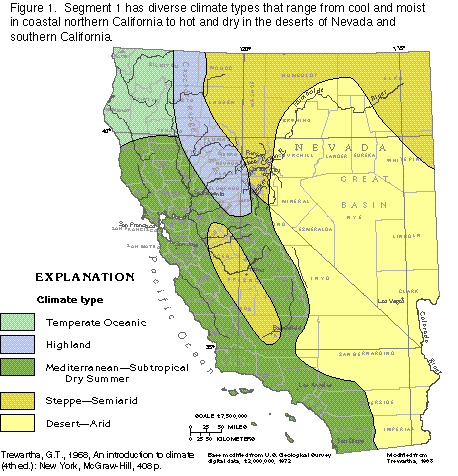
The diverse physiography and north-south extent of Segment
1 result in marked climatic contrasts within the region. Five
climate types in the Segment are based primarily on differences
in temperature and rainfall (fig. 1):
· Temperate Oceanic-Adequate precipitation in all seasons,
moderate summers and mild winters, cloudy conditions prevail
· Highland-Altitude, for the most part, controls the weather,
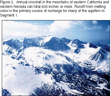
large amounts of precipitation as rain and snow in the mountains
(fig. 2), large diurnal temperature
ranges, rain shadows present on the leeward sides of mountain
ranges
· Mediterranean (Subtropical Dry Summer)-Modest precipitation
in winter, warm summers and mild winters, abundant sunshine
· Steppe (Semiarid)-Little precipitation, falling mostly
in winter, large annual temperature range
· Desert (Arid)-High temperature, scant precipitation,
large diurnal and annual temperature ranges, low relative humidity,
little cloud cover
Precipitation and Temperature
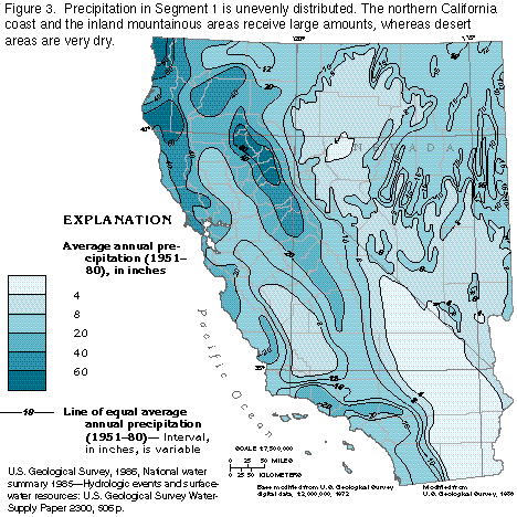
In California, much of the climatic variation results from the
patterns of global weather systems. Precipitation is greater in
the northern part of the State than elsewhere (fig.
3). However, prominent mountain ranges in California and western
Nevada also have an important influence on moisture distribution
in the region. Temperatures are cooler in the higher altitudes
of the mountains. As eastward-moving, moist, unstable air masses
rise up the western slopes of the mountains, the air is cooled
and water vapor condenses and falls as rain, snow, or ice. When
these air masses descend the eastern slopes, they become warmer
and more stable and thus retain most of the remaining moisture.
Consequently, precipitation amounts are much greater on the western
slopes of the north-south-trending mountain ranges of western
and eastern California, whereas semiarid to arid conditions prevail
east of the mountains, as in much of Nevada and in central and
southern California.
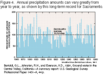
Storms that bring moisture to the region are most frequent in winter; about 80 percent of the annual precipitation falls between October and April. The extreme northern part of California has slightly wetter summers than the rest of the segment. However, amounts of precipitation vary greatly from year to year; for example, from 1860 to 1980 the average annual precipitation of Sacramento, Calif., was 18 inches, but precipitation ranged from 35 to 195 percent of the average annual precipitation (fig. 4), or from about 6 to 35 inches per year. Fog occurs frequently on the coast and provides some additional moisture that is used primarily by vegetation.
Mountain ranges that parallel the coast also affect temperature distribution. Seaward of the mountains, temperature is moderated by the ocean, and the range between daily high and low temperatures is usually less than 20 degrees Fahrenheit. Winters are cool, but they are not generally cold in coastal areas, although temperatures drop sufficiently in the coastal part of northern California to cause some frost and a dormant season for plants. Summers in coastal areas are mild, but temperatures occasionally become hot in southern California. In contrast, the valleys east of the coastal mountains experience much greater temperature extremes. In these valleys, summer daytime temperatures can be greater than 90 degrees but fall to 55 degrees or less at night. Winters in the interior valleys are relatively mild, and freezes are uncommon.
Temperature ranges in the mountains of western California and
eastern Nevada, as well as in the desert parts of Nevada and southern
California, are much greater than in other parts of Segment 1.
In the mountains and deserts very little moisture is in the air
to absorb the rays of the sun, or to retain heat at night. Consequently,
solar radiation is intense during the day, but the heat stored
in the ground is released rapidly after sunset. Temperature extremes
are hotter and colder in the desert than in other lowland areas
elsewhere in the segment, but mountainous areas are warm in summer
and extremely cold in winter.
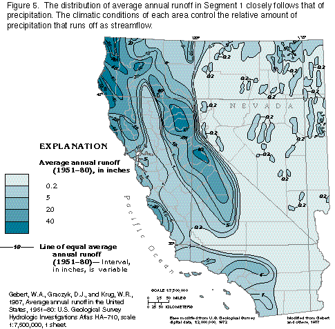
Runoff
Runoff is the amount of water left from precipitation that can
be measured as streamflow after losses to evaporation, transpiration
by plants, and the replenishment of storage within the aquifers.
The areal distribution of runoff from 1951 to 1980 (fig.
5) closely followed the areal distribution of precipitation
for the same period (fig. 3), but the
relative amounts of runoff varied as a result of climatic conditions.
Runoff is greatest in the mountains, where the majority of precipitation
falls as snow, which melts in the spring and runs off with minimal
evapotranspiration (the process by which liquid water is converted
to water vapor either by evaporation or by transpiration from
plants). Runoff is greater than 40 inches per year in many mountainous
areas. The basins in the arid parts of Nevada and southeastern
California have virtually zero runoff because most precipitation
that falls is evaporated almost immediately. However, high-intensity
storms or rapid snowmelt in the mountains that border the basins
may cause flash floods that reach the floors of the basins. Coastal
areas have a direct relation between the amount of precipitation
and runoff.
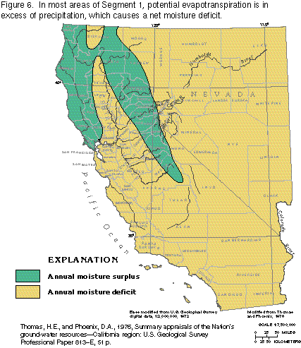
Water Surplus and Deficit
The relation between precipitation and evapotranspiration is a
major factor in water availability. Generally, if annual precipitation
exceeds annual potential evapotranspiration, then there is a net
surplus of water and streamflow is perennial. However, annual
potential evapotranspiration can exceed annual precipitation,
which causes a net deficit of water. A net annual moisture deficit
is present almost everywhere in California and Nevada (fig.
6). The only areas with an annual moisture surplus are the
northern California coast, which receives considerable rainfall
from winter storms, and the mountainous regions of northern and
east-central California, where condensation of water vapor in
rising, moist air masses results in abundant rain or snow. Water
is available to recharge aquifers only at times when precipitation
or snowmelt is greater than actual evapotranspiration. Thus, not
all areas mapped as having a net water surplus in figure 6 are
recharge areas.
In most of Nevada and in southern California, nearly all streams that head in the mountains are ephemeral and lose flow to alluvial aquifers within a short distance of where the streams leave the mountains and emerge onto the valley floors. In much of northern California and in the Humboldt, the Truckee, the Carson, and the Walker River drainages of Nevada, however, runoff is sufficient to support perennial streams. The Colorado River is supplied primarily by runoff from the Rocky Mountains. Before the inception of agriculture, the largest rivers in the vast Central Valley of California overflowed their banks during periods of peak winter flows and formed extensive marshlands. An elaborate flood control system and the lowering of the water table by withdrawals for irrigation now keep these rivers within their banks.
The geographical distribution of moisture in Segment 1 greatly influences patterns of agricultural and urban development. Much of Nevada receives little precipitation, and, consequently, ground- and surface-water supplies are limited. This limitation has severely restricted urban development and has put constraints on agricultural development. Las Vegas, the largest urban area in the State, obtains most of its water from the Colorado River, which is many miles away.
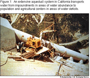
California receives relatively abundant precipitation. However, the precipitation is concentrated in areas of the State remote from most of the large urban centers and major agricultural areas. A further complication is the unpredictability of precipitation on an annual basis, which can often make surface-water supplies undependable. To provide a dependable, year-round supply of water to areas where it is most needed is a full-time, massive undertaking, and is accomplished by careful water management and an extensive water-transportation network (fig. 7).
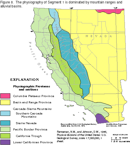
PHYSIOGRAPHY AND LAND USE
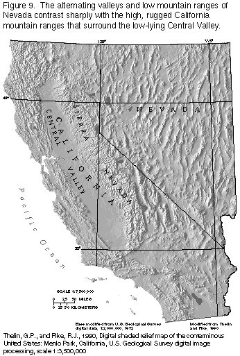
The physiography of the region (fig. 8) is a product of the geologic history of the area. Several coastal mountain ranges underlain by severely folded, faulted, commonly metamorphosed marine and continental sediments, form the Pacific Border and the Lower Californian Physiographic Provinces. In the interior, the granitic rocks that underlie the fault blocks of the Sierra Nevada and the volcanic rocks of the southern Cascade Mountains join to form the eastern border of the low-lying California Trough, which contains the Central Valley. East of the Sierra Nevada, the land is characterized by a series of low, north-south-trending mountain ranges and intervening valleys (fig. 9); the ranges and valleys were created by faulting that resulted in the horst and graben structures that form the Basin and Range Physiographic Province. In the extreme northeastern part of Nevada, the southernmost extent of the Columbia Plateaus Physiographic Province is formed by basalt lava flows.
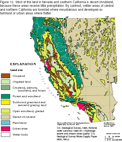
Land use in Segment 1 is directly related to topography and the availability of water. Major land uses in California and Nevada are shown in figure 10. The flat floor of the Central Valley of California, one of the Nation's most important agricultural areas, is used almost entirely for growing crops. Most of the cropland, however, must be irrigated. The mountains that surround the Central Valley are areas of rugged topography and, accordingly, are used predominantly as forest and woodland, even though they receive large amounts of precipitation. Almost all of Nevada and large parts of southern California receive little precipitation; accordingly, most of the land in these areas is desert shrubland (compare figs. 5 and 10), although sufficient water is available to allow livestock to be grazed in some places.
The major cities in the coastal areas of California appear as large areas of urban sprawl on figure 10. Although coastal California receives moderate to large amounts of precipitation, surface-water and ground-water supplies in those urban areas are not sufficient to provide the water needs of the population. As a result, a huge network of reservoirs, canals, and aqueducts has been constructed in California to transport water to these urban areas and other areas of water deficit.
MAJOR AQUIFERS
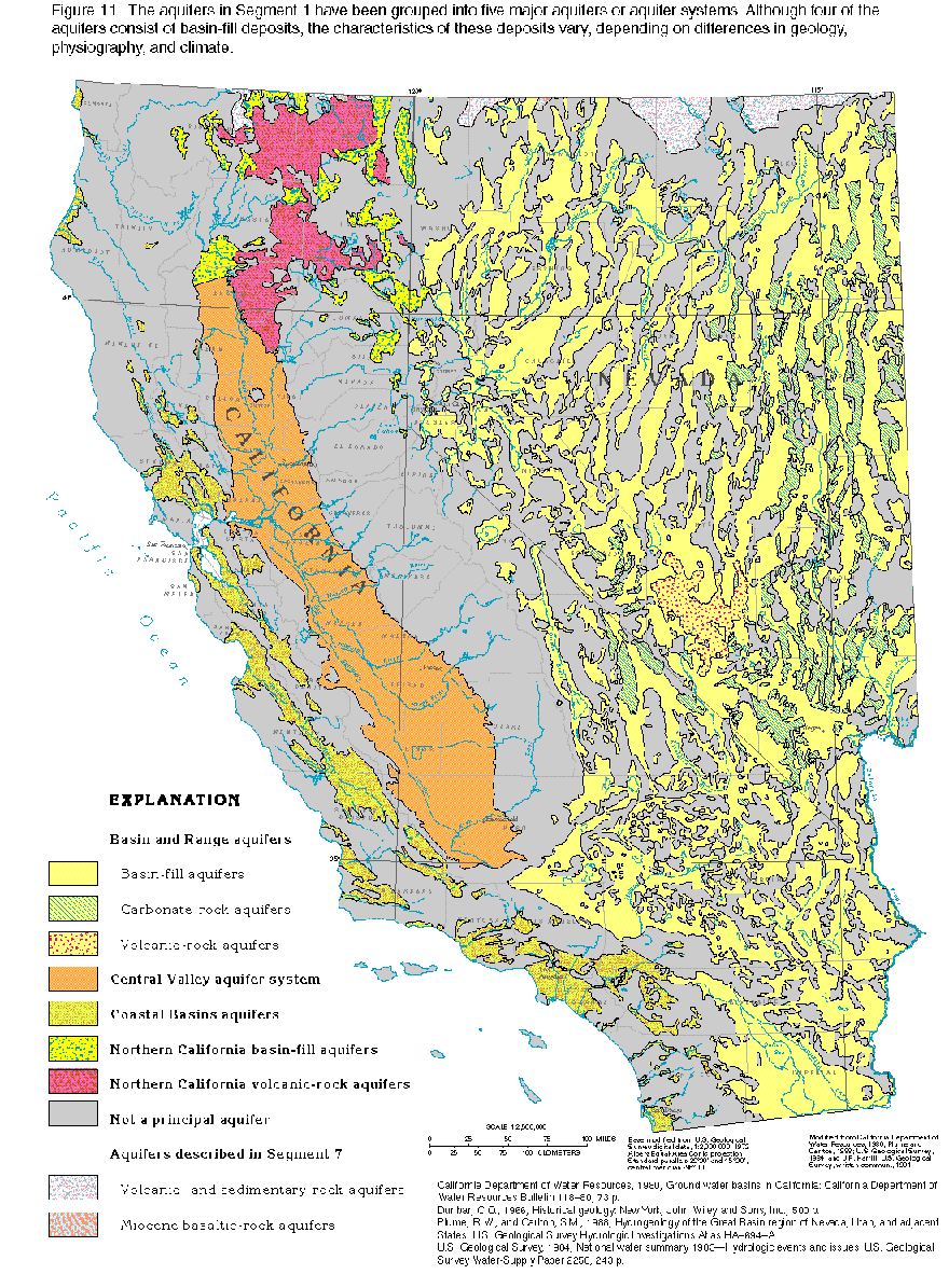
Ground water in Segment 1 is contained in five major aquifers (fig. 11), four of which consist primarily of basin-fill deposits that occupy structural depressions caused by deformation of the Earth's crust. The four basin-fill aquifers are the Basin and Range aquifers, the Central Valley aquifer system, the Coastal Basins aquifers, and the northern California basin-fill aquifers. The fifth major aquifer is the northern California volcanic-rock aquifers. Few of these aquifers extend over an area large enough to be termed "regional." An exception is the Central Valley of California, which is a very large basin-fill aquifer best described as a "regional" aquifer. Some water in Segment 1 is obtained from areally-extensive volcanic and carbonate rocks, but water within these rocks is mostly in fractures or solution openings and, consequently, the rocks generally yield little water. One notable exception is in eastern Nevada, where some alluvial basins are hydraulically connected by widespread deposits of permeable carbonate rocks that underlie the alluvium. In some places, consolidated rocks are hydraulically connected to overlying unconsolidated deposits and, thus, are part of the same aquifer or aquifer system.
Because of the scattered, local nature of most of the aquifers, it is difficult to classify them. The grouping used herein is based on geology, physiography, and climate but is not the only one possible. The areas designated "not a principal aquifer" lack sufficient basin-fill sediments or permeable consolidated rock to yield significant amounts of water to wells.
The Basin and Range aquifers are located in an area that comprises most of Nevada and the southern California desert (fig. 11). The water-yielding materials in this area are in valleys and basins, and consist primarily of unconsolidated alluvial-fan deposits, although locally flood plain and lacustrine (lake) beach deposits may yield water to wells. Also, the consolidated volcanic and carbonate rocks that underlie the unconsolidated alluvium are a source of water if the consolidated rocks are sufficiently fractured or have solution openings. Many of these valleys and basins are internally drained; that is, water from precipitation that falls within the basin recharges the aquifer and ultimately discharges to the land surface and evaporates within the basin. Ground water is generally under unconfined, or water-table, conditions at the margins of the basins, but as the unconsolidated deposits become finer grained toward the centers of the basins, the water becomes confined. Rarely, basins might be hydraulically connected in the subsurface by fractures or solution openings in the underlying bedrock. These multiple-basin systems end in a terminal discharge area, or sink, from which water leaves the flow system by evaporation. Also, several basins or valleys may develop surface-water drainage that hydraulically connects the basins, and ground water flows between the basins, mostly through the unconsolidated alluvial stream/flood plain sediments.
The Central Valley aquifer system (fig.11) occupies most of a large basin in central California between the Sierra Nevada and the Coast Range Mountains. The Central Valley is the single most important source of agricultural products in the United States, and ground water for irrigation has been essential in the development of that industry. The basin contains a single, large, basin-fill aquifer system, the largest such system in the Nation. Although the valley is filled with tens of thousands of feet of unconsolidated sediments, most of the fresh ground water is at depths of less than 2,500 feet. Ground water in the valley is under unconfined to confined (artesian) conditions, primarily depending on depth; most of the shallow ground water is unconfined.
The Coastal Basins aquifers occupy a number of basins in coastal areas from northern to southern California (fig. 11). These basins have similar morphology and a Mediterranean climate. All are in structural depressions formed by folding and faulting, all are filled with marine and alluvial sediments, and all are drained by streams that contain water at least part of the year. Nearly all the large population centers in Segment 1 are located in these basins, and the available ground water is used primarily for municipal supplies. In most of the basins, however, population has grown to such an extent that local ground-water supplies are no longer adequate, and surface water must be transported from distant sources to meet demand. Ground water in the basins is under unconfined to confined conditions, and two or more vertically sequential aquifers can be present in a basin, separated by confining units that consist of fine-grained sediments. In nearly all basins that contain more than one aquifer, however, the aquifers are hydraulically connected to some degree. Seawater intrusion is a common problem in nearly all the Coastal Basins aquifers.
Interior northern California is sparsely populated, and most ground-water demand is for agricultural irrigation. The most productive and highly-utilized aquifers in the area are the northern California basin-fill aquifers (fig. 11). These aquifers are in unconsolidated alluvial sediments. However, in some basins, wells drilled into underlying volcanic rocks might produce large quantities of water, often more than wells completed in the unconsolidated sediments.
The northern California volcanic-rock aquifers consist of volcanic rocks that yield water primarily from fractures and locally from intergranular spaces in porous tuffs. Because water-yielding zones in these rocks are unevenly distributed, wells that yield water are outnumbered by dry holes; however, in some areas, wells completed in the volcanic-rock aquifers yield large volumes of water. The northern California volcanic-rock aquifers are relatively unexplored and undeveloped.
GEOLOGY AND GEOLOGIC HISTORY
Rocks and deposits exposed at the surface in Segment 1 range in age from Precambrian to Quaternary (fig. 12). They consist of igneous intrusive rocks, pyroclastic and extrusive volcanic rocks, and marine and continental sediments, many of which, particularly the older rocks (pre-Mesozoic) have been intensely metamorphosed, folded, and faulted.
The principal water-yielding units are unconsolidated continental clastic deposits of Cenozoic age that partly fill structural basins created by faulting. Volcanic rocks, which are principally lava and pyroclastic flows of Cenozoic age, are important aquifers in scattered areas. Paleozoic limestones and dolomites associated with basin-fill Cenozoic clastic deposits in eastern Nevada are the only older rocks with significant water-yielding potential.
During Precambrian time and the Paleozoic Era, an almost uniform thickness of approximately 40,000 feet of marine sediments was deposited in the Cordilleran geosyncline. This geosyncline was an elongated trough that extended north to south in western North America and included the area that is now eastern Nevada and southern California. Sedimentation was marked by two periods of alternating clastic and carbonate deposition that resulted in the following sequence: quartzite and siltstone, limestone and dolomite, argillite and quartzite, and limestone.
At the end of the Paleozoic Era, volcanoes were active on a grand scale in eastern California and western Nevada. This volcanism marked the beginning of igneous activity that was to become increasingly important during Mesozoic time.
A number of shallow marine invasions inundated parts of the region during the Mesozoic Era. Conditions were such that marine formations alternated with nonmarine deposits derived from erosion of rocks in the continental interior. During this time, a coastal strip as much as 400 miles wide was formed by a combination of marine sedimentation and igneous activity, granitic intrusions, and subaerial volcanism, and was welded to the western margin of the preexisting continental mass.
The early Mesozoic seas spread inland as far as central Utah and Wyoming but were soon blocked by a narrow uplift in central Nevada. During the remainder of the Mesozoic Era, only intermittent subaerial deposition took place east of this uplift. West of the uplift, a thick sequence of Mesozoic marine and continental sediments was deposited, interspersed with lava flows, volcanic breccia, and tuff.
The close of middle Mesozoic time culminated in the first great orogeny in the western part of North America since Precambrian time. As mountain ranges rose, the marine, continental, and volcanic deposits of the Pacific Coast were folded, metamorphosed, and complexly faulted. Intense deformation of the older rocks spread eastward across most of Nevada. Late in the Mesozoic Era, the Pacific coastal region was again downwarped and the sea intruded.
During the Cenozoic Era, volcanic rocks and sedimentary deposits accumulated over wide areas of Segment 1, to thicknesses of as much as 50,000 feet. Early in the Cenozoic Era, the Basin and Range area was a high mountain surface with external drainage. During middle to late Cenozoic time, however, large-scale block faulting formed the Coast Range Mountains, the California Trough, and the Sierra Nevada and caused the Basin and Range structures. These structures are a sequence of alternating horsts and grabens that trend north-south and are reflected in the present-day topography. Volcanism, which still continues today, formed much of the Cascade Mountains.
In late Cenozoic time, the California Trough and the structural basins in the Coast Range were filled with marine and terrestrial deposits that ranged from a few thousand to as much as 50,000 feet in thickness. The grabens of the Basin and Range were filled with continental deposits and minor lava flows to thicknesses of generally less than 2,000 feet, but locally as much as 50,000 feet. The late Cenozoic also was the time of development of basins in the mountains of northern California and Nevada. These basins were filled with clastic sediments and numerous basaltic lava flows.
FRESH GROUND-WATER WITHDRAWALS
Ground water is an important resource in California and Nevada and accounted for nearly 40 percent of all freshwater used in the two States during 1985 (fig. 13). Fresh ground-water withdrawals in California during this period were about 16 times as much as those in Nevada. In Segment 1, irrigated agriculture accounts for the greatest amount of ground-water use, followed by withdrawals for public supplies. More than 25 million people, or about 66 percent of the population of the two-State area, depend on publicly supplied ground water.
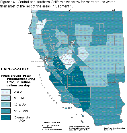
Total withdrawals of fresh ground water during 1985, by county, are shown in figure 14. Counties with the largest withdrawals are those where vast areas are irrigated, such as the Central Valley of California, or counties having large population centers. The large withdrawals shown for central Nevada and some southern California counties are somewhat misleading. These areas are largely desert, and because of the extremely large size of some of the counties, small withdrawals in scattered pumping centers plot as unrealistically large withdrawals when totalled for counties that contain hundreds of thousands of square miles.
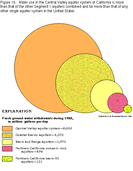
The Central Valley aquifer system had the largest ground-water withdrawal in Segment 1 during 1985 (fig. 15). Approximately 9,000 million gallons per day (about 10 million acre-feet per year) was withdrawn from the Central Valley aquifer system. Of that amount, approximately 8,000 million gallons per day, or 8.9 million acre-feet per year, was withdrawn for irrigation and accounted for about 11.5 percent of all ground-water withdrawals in the United States. One acre-foot, or 43,560 cubic feet of water, is the volume of water that will cover an area of 1 acre to a depth of 1 foot.
The Coastal Basins aquifers supply the largest population centers in Segment 1 and are second only to the Central Valley aquifer system in total ground-water withdrawals (fig. 15). Much ground water is withdrawn for agricultural use in these coastal basins, but public supply accounted for about 54 percent of the approximately 4,370 million gallons per day (about 4.9 million acre-feet per year) withdrawn during 1985; this is due primarily to the large population in the coastal cities of southern California that depend heavily on ground water for public supply.
Irrigated agriculture is the largest user of fresh ground water withdrawn from the Basin and Range aquifers. Although ground water is a significant source of water for public supplies, large population centers, such as Las Vegas, the Carson City area, and the RenoSparks area, depend heavily on surface water for their public supplies. The desert basins receive little precipitation during the year, and surface and ground water are scarce, which limits population growth in the region.
The northern California volcanic-rock aquifers and the northern California basin-fill aquifers together supplied only 5 percent of the total fresh ground water withdrawn in Segment 1 during 1985. These aquifers compose only a small part of the segment, and the demand for ground water in northern California is not great.