INTRODUCTION
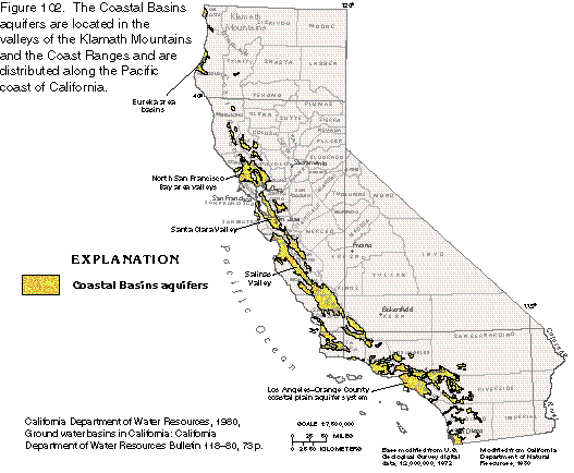
The California coastal region has been subjected to intense tectonic
forces for millions of years. Folding, faulting of marine sediments,
and associated volcanism resulted in the formation of the Klamath
and the Salmon Mountains in northern California and the Coast
Ranges that extend along most of the California coast. Terrestrial,
marine, and volcanic rocks deposited in intermontane valleys compose
the aquifers herein called the Coastal Basins aquifers (fig.
102). The California Department of Water Resources considers
more than 100 coastal basins to be "significant" because
of the amount of ground water potentially obtainable or the scarcity
of surface-water sources in a basin. Nearly all of the large population
cen-ters in California are located in the coastal basins.
The climate along the coast of California is moderated by the Pacific Ocean and is essentially Mediterranean, characterized by cool winters and warm summers. Precipitation is seasonal and usually in the form of rain. The greatest amounts of precipitation fall during late autumn, winter, and early spring. Precipitation amounts are greatest in northern California and progressively decrease southward. Altitude also influences precipitation patterns; the greatest amounts of precipitation fall in the mountains. Potential annual evaporation in the valleys exceeds annual precipitation from San Francisco Bay southward. As a result, most unregulated rivers in southern California are dry in their lower reaches during the summer months.
GEOLOGIC SETTING
The intermontane basins in the coastal mountains of California are structural troughs or depressions that parallel the coastline and formed as a result of folding and faulting (fig. 103). Most of the folds and faults trend northwestward and result from the deformation of older rocks by the intense pressures of colliding continental plates. The rocks that underlie the basins and form the surrounding mountains are primarily marine sediments and metamorphic and igneous rocks, all of which are of Mesozoic age but locally include rocks of Cenozoic age.
The basins are partly filled with unconsolidated and semiconsolidated marine sedimentary rocks that were deposited during periodic encroachment of the sea and with un-consolidated continental deposits that consist of weathered igneous and sedimentary rock material which was transported into the basins primarily by mountain streams. These marine sediments and continental deposits are tens of thousands of feet thick in some basins. In the basins just north of San Fran- cisco Bay, permeable basalt and tuff compose a portion of the materials overlying the older consolidated rocks. In most basins, however, almost all of the permeable material consists of unconsolidated continental deposits, primarily sand and gravel (fig. 103).
GEOHYDROLOGIC SETTING
In all the basins, most of the freshwater is contained in aquifers that consist of continental deposits of sand and gravel that might be interbedded with confining units of fine-grained material, such as silt and clay. The aquifers and confining units compose an aquifer system. Water enters a typical coastal-basin aquifer in several ways. Runoff from precipitation in the surrounding mountains infiltrates the permeable sediments of the valley floor either at the basin margins or through streambeds where the water table is lower than the water level in the stream. Precipitation that falls on the valley floor provides some direct recharge, but in the coastal basins, most of the precipitation evaporates or is transpired by plants. In a few basins that are hydraulically connected to other basins, water can enter an aquifer system as lateral subsurface flow from an adjacent basin. Of these methods of recharge, runoff from the mountains and percolation through streambeds provide the largest amounts of water to the ground-water system.
Natural movement of water in the aquifers is generally parallel to the long axis of the basin (fig. 103) because of impermeable rocks that commonly form a barrier between the basin and the sea. However, in a few coastal basins, most notably in the Los AngelesOrange County coastal plain, the coastal barrier is absent, and the natural direction of flow is perpendicular to the long axis of the basin or from the inland mountains to the sea. Before major development, ground water in all the basins discharged directly into the ocean or into bays connected to the ocean. After development, however, most or all the ground water is withdrawn by wells in the basins.
Although all the coastal basins have similar hydrogeologic settings, each is different in its geologic history and land- and water-use characteristics. Because it is beyond the scope of this Atlas to describe all of the coastal basin aquifers, only the basins with the largest ground-water withdrawals are described in this section.
FRESH GROUND-WTER USE AND MANAGEMENT
During the early years of ground-water development in the coastal basins, from the 1850's to early 1900's, the principal use of water was for irrigated agriculture. Although agricultural ground-water use remains substantial, urbanization has gradually replaced most agricultural land in the larger basins and the greatest collective ground-water demand is now for public supply. The largest water users are cities and suburbs from San Francisco southward, but because of the unequal distribution of rainfall, most of the freshwater is in northern California. Accordingly, it has become necessary to regulate streamflow and import water into many coastal basins from the Sierra Nevada, the Colorado River, the Owens Valley, and northern California through an extensive system of aqueducts.
For many years, rapidly growing populations in several basins resulted in ground-water withdrawals that exceeded natural recharge on a long-term basis; this led to marked water-level declines. The consequences of these excessive withdrawals ranged from mild, such as increased pumping costs, to severe, such as land subsidence and seawater intrusion. Today (1995), ground water in the coastal basins of California is carefully managed. The current supply of water from all sources, including imported water, approximately balances demand. However, because the natural recharge to many basins, especially southward from the San Francisco Bay area, is far less than the volume of ground water currently (1995) withdrawn, increases in population will require either additional imports, more conservation, an increase in the amount of water now reclaimed, or a combination of all three. More than any other environmental factor, water availability will likely determine the size of the population these basins can support.
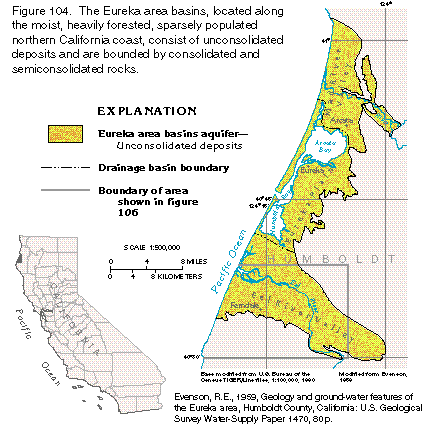
EUREKA AREA BASINS
The Eureka area basins, which consist of the Mad River Valley, the Eureka Plain, and the Eel River Valley, are located southwestward of the Klamath Mountains at the north end of the Coast Ranges (fig. 104). The basins are not densely populated; agriculture and timber are the major industries in the area, and pastureland accounts for most of the agricultural acreage.
The predominant feature of the Eureka area is Humboldt Bay, which is separated from the ocean by spits. Humboldt Bay, the northern end of which is known as Arcata Bay, extends 12 miles parallel to the coastline and is 0.5 to 4 miles wide. The land on the inland side of the bay is flat to gently rolling. The shoreline of the bay has a well-developed beach from which dunes extend inland a short distance over the alluvial plain.
The major streams that drain the area are the Eel River, which flows into the Pacific Ocean south of Humboldt Bay, and the Mad River, which flows into the Pacific Ocean north of the bay. Several small streams also flow into Humboldt Bay. All the streams are tidally influenced and have brackish-water marshes and mud flats along their banks for as much as 1 to 2 miles inland.
Coastal northern California has a Temperate Oceanic climate, which is characterized by moderate temperature and precipitation. Dense fog is frequent and tends to attenuate temperature fluctuations. The average annual precipitation at Eureka is approximately 40 inches per year, most of which falls during the autumn and winter months. Precipitation increases with altitude, and amounts are greater inland in the foothills and mountains.
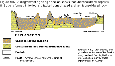
Aquifers and Confining Units
Unconsolidated deposits of sand, gravel, silt, and clay, which
are Pliocene and younger and primarily of alluvial origin, compose
the Eureka area aquifers (fig. 104).
Near the coast, the alluvial deposits interfinger with estuarine
sediments and locally are underlain by marine sediments. The thickness
of the unconsolidated deposits ranges from only a few feet to
as much as 1,000 feet (fig. 105). The
unconsolidated deposits range from coarse to fine grained. The
most permeable deposits are surficial alluvium and dune sands.
Virtually all fresh ground water is withdrawn from these deposits,
but deeper beds yield water in some places. The permeability of
the unconsolidated sediments varies with location, however, and
well yields vary accordingly. Consolidated and semicon-solidated
rocks of minimal permeability form the boundaries of the aquifer
system.
Distinct confining units are scarce in the unconsolidated deposits, but large total thicknesses of fine-grained sediments can impede vertical flow sufficiently to create an increase in hydraulic head with depth. Consequently, depending upon the permeability and depth of the water-yielding deposits at a particular location, ground water can be under either confined or unconfined conditions.
The primary fresh ground-water body in the Eureka area is in the Eel River Valley, where ground water under unconfined, or water-table, conditions is available nearly everywhere at depths of 30 feet or less. An exception is in the vicinity of Ferndale, where sediments are fine grained, have minimal permeability, and yield little water to wells except near the mouths of streams, where the sediments are coarse grained and fluvial. A perched water table is above clay beds that form a local confining unit in terrace deposits near the Eel River. Water in the deeper parts of the aquifer in the Eel River Valley, near Humboldt Bay in the Eureka Plain, and in the Mad River Valley, between Eureka and Arcata, is under confined or partially confined conditions.
Ground-Water Movement
The aquifer is recharged primarily by runoff from the hills that
surround the stream valleys and by seepage from the upper reaches
of streams. Minor recharge is by lateral movement of water from
adjacent rocks and by direct precipitation. Deeply-buried sediments
are recharged by precipitation where they crop out and by leakage
from shallower water-yielding beds to which they are hydraulically
connected, especially where withdrawals from the deep sediments
are sufficient to cause a downward hydraulic gradient. Ground-water
movement in the surficial deposits is generally toward the coast
(fig. 106), where the water mostly
discharges into estuarine reaches of the rivers; some water discharges
directly into Humboldt Bay or the Pacific Ocean, or is withdrawn
by wells. Water in the deeper sediments is discharged by vertical
flow to shallower deposits where the hydraulic gradient is upward,
or is withdrawn by deep wells.
Fresh Ground-Water Withdrawals
Irrigation of pastureland accounts for most ground-water use in
the Eureka area, followed by withdrawals for industry and public
supply. Most of the withdrawals for irrigation are in the coastal
plain of the Eel River Valley. The cities of Eureka and Arcata
use surface water for their public supplies, whereas many of the
smaller communities use ground water. Total estimated ground-water
withdrawals during 1972 were 9,000 acre-feet in the Mad River
Valley, 15,000 acre-feet in the Eureka Plain, and 10,000 acre-feet
in the Eel River Valley. This is more than double the estimated
total withdrawal of 15,000 acre-feet during 1952, but current
(1995) rates of ground-water withdrawal do not appear to be in
excess of natural recharge. Therefore, no shortage of water is
likely as long as surface-water supplies remain adequate to supply
municipal demands.
Ground-Water Quality
The quality of ground water in the Eureka area is generally acceptable
for most uses, although concentrations of dissolved iron in water
from many wells may exceed the U.S. Environmental Protection Agency's
secondary drinking-water recommendation of 300 micrograms per
liter. Chloride concentrations in excess of the 250 milligrams
per liter drinking-water recommendation are reported in water
from wells near the Eel River as much as 4 miles inland from the
Pacific Ocean, suggesting that the source of the chloride is brackish
water from the tidal reaches of the river. Shallow wells in the
dune sands also are prone to seawater intrusion because they must
obtain freshwater from a thin lens that floats on saltwater. Excessive
withdrawals or minimal recharge lower the freshwater head in the
dunes and allow salty water to be drawn into wells.
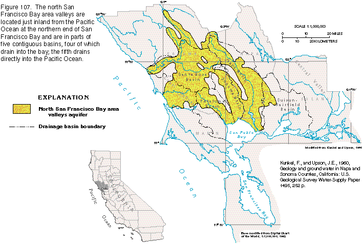
NORTH SAN FRANCISCO BAY AREA VALLEYS
Among the Coast Ranges north of San Francisco Bay are several valleys underlain by aquifers from which moderate to large volumes of water are withdrawn (fig. 107).The Petaluma, the Sonoma, the Napa, and the SuisunFairfield Valleys drain into San Pablo Bay, and the Santa Rosa Basin drains into the Russian River, which empties into the Pacific Ocean.
The north San Francisco Bay area valleys contain a mixture of urban and agricultural lands. Population growth since the 1970's has been rapid and urban areas have replaced much of what was formerly agricultural land. Nonetheless, agriculture remains important to the local economy. Orchard crops are a significant part of the total agricultural output but are being replaced in many areas by vineyards. Many formerly unplanted hillsides now grow wine grapes.
Ground-water supplies in the area are limited by local availability and, to a degree, by the quality of the water. Most of the water used in the area is surface water, much of which is either derived from the Russian River or imported from the Central Valley. Ground water, however, remains the primary source of supply for agriculture, stock watering, and domestic uses and is an important source for municipal supply.
The five drainage basins of the north San Francisco Bay area valleys are structural troughs filled to great depths with marine and continental sediments and volcanic deposits. The basins each have a flat to gently rolling valley floor formed primarily on alluvial fan deposits. The slope of the fan steepens near the foothills at the base of the surrounding mountains. Some streams that drain mountain valleys are perennial only in their upper reaches because the water table falls below the level of the streambed during the dry season. The lower stream reaches are seasonally intermittent.
The North San Francisco Bay area has a Mediterranean-type climate, characterized by moderate temperatures and markedly seasonal precipitation that falls primarily during late autumn to early spring. Precipitation amounts are dependent on altitude, with average annual amounts that range from less than 20 inches in some valley locations to more than 60 inches in the higher elevations of the Coast Ranges.
Aquifers and Confining Units
The principal water-yielding materials in the north San Francisco
Bay area valleys are unconsolidated and semiconsolidated marine
and continental sediments and unwelded tuffaceous beds in volcanic
rocks (fig. 108). Consolidated rocks
of Cretaceous and Jurassic age that underlie the entire area have
little permeability and form the boundaries of the ground-water
flow system. The permeability and extent of water-yielding deposits
varies considerably. In all the valleys, alluvial-fan deposits
and stream-valley alluvium compose the major part of the aquifer.
Locally, marine and estuarine deposits of sand beneath the Santa
Rosa and the Petaluma Basins are an important source of ground
water. Volcanic tuff of Pliocene age in the areas of volcanic
rocks shown in figure 108 yields water to wells in the Sonoma
and the Petaluma Basins.
Ground water is under unconfined, or water-table, conditions in shallow alluvial deposits and locally where it is near the land surface in other types of rocks. The ground water is confined or semiconfined in deeper parts of the alluvial deposits and nonalluvial formations. Because of their lenticular nature, water-yielding deposits in the north San Francisco Bay area valleys are generally discontinuous and isolated. Further, many of the deep deposits are displaced by faults. As a result, the valleys are a collection of variously connected and isolated aquifers. Generally, the alluvial-fan and stream-valley alluvial deposits in each basin are sufficiently continuous to be considered single aquifers; however, because of the geologic complexity of the area and the limited availability of data, the exact extent and degree of continuity of many deep aquifers is unknown.
Ground-Water Flow System
Recharge to the ground-water flow system enters permeable sediments
at the valley margins primarily as runoff from precipitation in
the mountains and hills that surround the val-leys. Other sources
of recharge are precipitation that falls directly on permeable
deposits in low-lying areas of the valleys and seepage through
streambeds in areas where the water table is lower than the stream
level and the streambed sediments are sufficiently permeable to
permit infiltration into the aquifers. Discharge is by seepage
to gaining reaches of streams, spring discharge, evapotranspiration,
and withdrawals from wells.
All the basins are drained by streams that are perennial only in their upper reaches. The lower reaches become dry in summer because of infiltration where they are underlain by permeable deposits. The ground-water flow system in most basins is essentially self-contained, and interbasin transfer of water is minor.
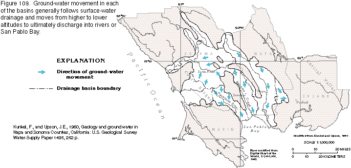
Ground-water movement generally followed surface-water drainage under natural, or predevelopment, conditions (fig. 109). The discontinuous nature of deep water-yielding materials makes it impossible to construct accurate basinwide water-level maps. However, the ground-water flow pattern in deep aquifers is likely to be similar to that of shallow aquifers. Withdrawals alter the direction of ground-water movement locally and can affect significant changes in regional flow patterns if withdrawal rates are relatively large. Present-day (1995) flow patterns, in general, do not differ significantly from those of predevelopment conditions except locally near withdrawal centers. Withdrawal in the past, however, has reversed the freshwater gradient and induced the intrusion of saltwater in the lower parts of the Napa, the Sonoma, and the Petaluma Valleys.
Fresh Ground-Water Withdrawals
Surface and ground water are used conjunctively in the north San
Francisco Bay area valleys. Several municipalities obtain a significant
amount of their supplies from imported surface water, either from
the Russian River or the aqueduct systems that serve San Francisco
Bay area cities to the south. Nonetheless, ground water is used
for some municipal supplies, as well as for irrigation, stock
watering, and domestic uses.
Currently (1995), ground-water recharge and discharge are approximately in balance on an average annual basis in most areas, and withdrawals in excess of recharge are not common. However, because of the relatively limited storage capacity of the aquifers, as well as water-quality concerns, the amount of additional ground water that can be withdrawn without adverse effects is restricted. Although lowering of the water table can allow infiltration of additional recharge that might normally be rejected, withdrawal in excess of recharge can deplete ground-water reserves and possibly cause the migration of poor-quality water into wells. Careful monitoring of local and regional water levels will always be necessary to ensure proper use of the resource.
Ground-Water Quality
The quality of ground water in the north San Francisco Bay area
valleys is generally suitable for most purposes. However, some
problems, such as locally large concentrations of chloride, sodium,
boron, nitrate, iron, and manganese, might restrict use of ground
water for some applications.
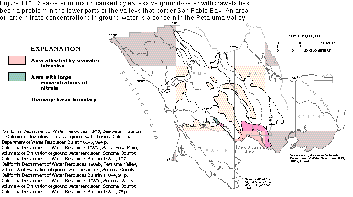
Large concentrations of chloride can make water unusable for drinking and can also be toxic to plants. Drinking-water recommendations of the U.S. Environmental Protection Agency suggest a chloride concentration of less than 250 milligrams per liter. However, chloride in concentrations as low as 106 milligrams per liter may be toxic to some plants; such concentrations have been detected in ground water in the Santa Rosa Basin. Sources of chloride in the north San Francisco Bay area aquifers include seawater intrusion, thermal water, and dissolved minerals from marine and volcanic rocks. The valleys most affected by large chloride concentrations are the Petaluma, the Sonoma, and the Napa, in which seawater intrusion caused by excessive ground-water withdrawals has been the primary source (fig. 110). Reduced withdrawals and increased surface-water imports have helped alleviate the salinity problem.
Excessive sodium in irrigation water can be toxic to plants and can decrease soil permeability. Possible sources of sodium in the north San Francisco Bay area valleys include cation exchange between ground water and clay minerals, upward migration of salty water along faults, dissolved minerals in water from marine sediments, thermal water, and seawater intrusion.
Sodium is often the dominant cation in ground water in the north San Francisco Bay area valleys and has been reported locally in concentrations in excess of 250 milligrams per liter, which is sufficiently large to be of concern. The problem is widespread in the Santa Rosa Basin, where large sodium concentrations are thought to be related primarily to cation exchange. The source of excessive sodium in the other four valleys could be one or all of the sources listed above, but seawater intrusion is the primary source in the alluvial-fan deposits in the southern ends of the Petaluma, the Sonoma, and the Napa Valleys.
Although essential to plant growth in small amounts, boron in excess of 0.5 milligram per liter can be stressful or toxic to many plants, and water with a boron concentration of greater than 2.0 milligrams per liter is toxic to most plants. Boron is usually associated with water that has a large sodium concentration and the sources for boron in the area are generally the same as for sodium. Ground water that has a boron concentration of 0.5 milligram per liter or larger is found in scattered wells throughout the north San Francisco Bay area.
The presence of nitrate in ground water is usually an indication of contamination by septic tanks, fertilizers, or waste from farm animals. Large nitrate concentrations can cause methemoglobinemia (a blood disease) in infants, and State drinking-water standards in California have been set at 45 milligrams per liter of nitrate, or 10 milligrams per liter nitrogen. Nitrate is not a widespread problem in most of the north San Francisco Bay area, except locally, northwest of Petaluma (fig. 110) where nitrate concentrations are as large as three times the maximum allowed for drinking water. The probable sources appear to be septic-tank leachate plus livestock and poultry manure that was placed in unlined pits.
SANTA CLARA VALLEY
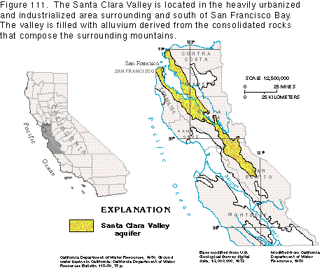
The Santa Clara Valley is located at the southern end of San Francisco Bay (fig. 111). Once devoted largely to agriculture, most of the land in the valley is now dedicated to industrial and urban uses. Population growth has resulted in a large water demand, which has exceeded the valley's natural supply since the early 1940's. Withdrawals of ground water in excess of recharge caused large water-level declines, which were followed by seawater intrusion and land subsidence surpassed in California only by that in the San Joaquin Valley. Since the 1940's, importation of surface water has been essential to the control of these problems.
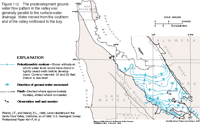
The Santa Clara Valley is in a structural trough that parallels the northwest-trending Coast Ranges. The drainage basin, which includes San Francisco Bay, is bounded by the Santa Cruz Mountains on the southwest and the Diablo Range on the northeast. The basin is about 75 miles long and has a maximum width of 45 miles. The San Andreas Fault is in the Santa Cruz Mountains to the southwest, and the Hayward Fault is on the northeast side of the valley and parallels the Diablo Range (fig. 112). The Santa Clara Valley, which occupies the southern end of the basin, is about 60 miles long, about 30 miles of which extends southeastward beyond San Francisco Bay. The valley has a maximum width of about 15 miles and a total area of about 590 square miles. The altitude of the valley floor ranges from about 350 feet at the southern end to sea level at San Francisco Bay.
The Mediterranean climate of the valley is moderate and has distinct wet and dry seasons. The wet season extends from November to April. Average annual rainfall is about 14 inches on the valley floor.
Aquifers and Confining Units
The aquifer system of the Santa Clara Valley is bounded on three
sides by the relatively impermeable consolidated rocks that form
the mountains surrounding the valley (fig.
112) and underlie the valley at depth. Ground water in the
valley is contained primarily in coarse-grained lenticular deposits
of sand and gravel that alternate with discontinuous beds of fine-grained
clay and silt that have minimal permeability. The combined thickness
of the coarse- and fine-grained deposits is as much as 1,000 feet
in some parts of the valley. The alluvial-fan and river-channel
deposits near the valley margins contain a higher percentage of
coarse-grained materials than deposits near the valley axis and
are thus more permeable.
Although interspersed with coarse-grained channel deposits, the cumulative thickness of clay and silt is sufficient in the central two-thirds of the valley to produce confined conditions in the subsurface from southeast of San Jose to beneath San Francisco Bay. Water below a depth of 150 to 200 feet in that area is confined or semiconfined, whereas shallower water is generally unconfined. The confined part of the aquifer system is as much as 800 feet thick, but locally it contains beds of fine-grained deposits that separate it into zones of permeable material sufficiently distinct to be recognized as individual aquifers.
Ground-Water Flow System
Water enters the aquifer system at the valley margins by infiltration
from the small streams that emanate from the mountains and by
rainfall that falls directly on the valley floor. The natural,
or predevelopment, flow pattern was generally parallel to the
direction of stream drainage, and water that did not leave the
aquifer system by way of evapotranspiration discharged into San
Francisco Bay (fig. 112). The Hayward
Fault acts as a major impediment to flow on the northeastern side
of the valley.
In 1915, the hydraulic head was above land surface throughout much of the valley, and flowing wells were common. However, by 1967, an increase in ground-water withdrawals, as well as below-normal rainfall, resulted in water-level declines of more than 200 feet below 1915 levels in some parts of the valley (fig. 113). Large withdrawals lowered water levels to below sea level over much of the valley and reversed the freshwater gradient in the confined zone from seaward to landward. This reversal resulted in seawater intrusion that was detected in wells as far as 10 miles inland. The large withdrawals also caused widespread land subsidence.
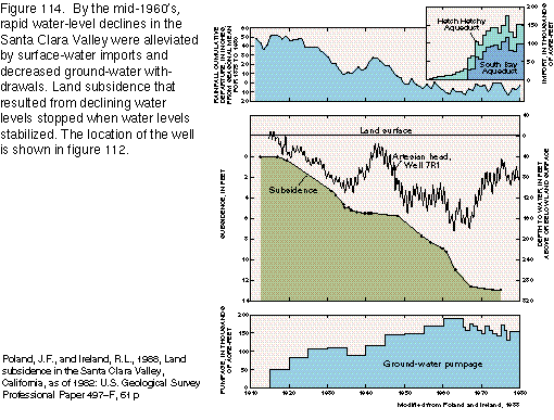
Beginning in the mid-1960's, the decline in artesian head was halted and reversed by a combination of surface-water imports and decreased ground-water withdrawals (fig. 114). Water importation into the Santa Clara Valley began in about 1940 by way of the Hetch Hetchy Aqueduct and was increased in the mid-1960's through the South Bay Aqueduct. By 1980, surface-water imports approximately equaled ground-water withdrawals. Projections of future water demand made in 1983, however, indicated that by 2000 small amounts of additional surface water will have to be imported and the distribution system improved.
Fresh Ground-Water Withdrawals
Significant ground-water use in the Santa Clara Valley began about
1900 with the development of irrigated agriculture. Average annual
agricultural withdrawals increased from about 40,000 acre-feet
per year from 1915 to 1920 to a maximum 5-year average of about
103,000 acre-feet per year from 1945 to 1950. After 1945, urban
and industrial development increased rapidly, and irrigated acreage
began to decline; agricultural withdrawals decreased to an average
20,000 acre-feet per year from 1970 to 1975. Meanwhile, municipal
and industrial withdrawals increased from about an average of
22,000 acre-feet per year from 1940 to 1945 to an average of 131,000
acre-feet per year from 1970 to 1975. Total withdrawals in the
valley increased from 50,000 acre-feet per year from 1915 to 1920
to 185,000 acre-feet per year from 1960 to 1965, and then declined
to about 150,000 acre-feet per year from 1970 to 1975 when surface-water
imports increased sufficiently to offset the excessive ground-water
withdrawals.
Municipal and industrial ground-water use began to exceed agricultural use early in the 1960's. Currently (1995), municipalities and industries account for about 90 percent of the water used in the valley. Ground water used for irrigated agriculture averaged about 14,000 acre-feet per year from 1975 to 1980, while the amount withdrawn for municipal and industrial use was about 150,000 acre feet per year. The combined annual agricultural, municipal, and industrial ground-water withdrawals of about 164,000 acre-feet were about one-half of the total water used in the valley.
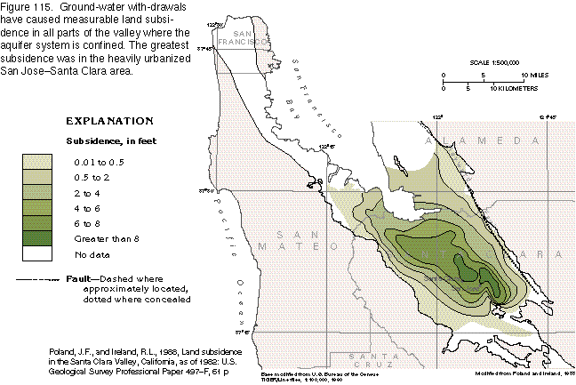
Land Subsidence
The Santa Clara Valley is underlain by large amounts of clay that
readily compacts as a result of excessive ground-water withdrawal,
thus causing land subsidence. Land subsidence has been evident
over much of the valley and is greater than 8 feet in some places
(fig. 115). Subsidence has resulted
in flooding in coastal areas and damage to roads, bridges, railroads,
and sewer systems. The cost of remedial measures has been estimated
to be between $30 million and $50 million annually. The rate of
subsidence slowed in 1967 as increased surface-water imports and
reduced ground-water withdrawals allowed the hydraulic head to
stabilize and start to recover. Under current (1995) conditions
of ground-water use and availability, further subsidence is not
likely. However, because the compression of the clay is irreversible,
land subsidence that has already occurred is permanent.
Ground-Water Quality
Ground-water quality is not a serious concern in the Santa Clara
Valley, except near San Francisco Bay, where seawater has intruded
locally as a result of large ground-water withdrawals. The encroachment
has been arrested, for the most part, by a decrease in withdrawals
and an increase in recharge from surface-water sources.
SALINAS VALLEY
The Salinas Valley, the largest southern California coastal basin, lies within the southern Coast Ranges between the San Joaquin Valley and the Pacific Ocean (fig. 116). The valley is drained by the Salinas River and extends approximately 150 miles from the headwaters to the mouth of the river at Monterey Bay. The total drainage area of the basin is about 5,000 square miles.
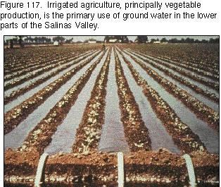
The major land uses in the Salinas Valley are agriculture, rangeland, forest, and urban development. In general, forest lands are on steep slopes, rangelands are in rolling to steep hills, and agricultural and urban development are in areas where slopes are gentle, especially near the Salinas River and its tributaries. Agriculture is the primary water use in the basin and is most intensive near the coast between the city of Salinas and Monterey Bay, where land is devoted primarily to vegetable production (fig. 117). Less land is under cultivation south of King City, where the major crops are grain and wine grapes. Most of the water used in the basin is ground water withdrawn near where it is used. No water is imported, and all recharge originates as precipitation in the drainage basin.
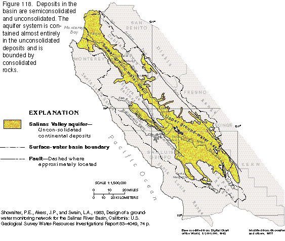
The Salinas Valley lies almost entirely in a northwest-trending structural trough filled principally by unconsolidated continental deposits. The valley is bounded by the San Andreas Fault on the northeast and by a series of aligned and interconnected faults on the southwest (fig. 118). The mountains that bound the valley were formed by uplift and deformation caused by crustal shortening and are underlain by consolidated marine sediments, intrusive igneous rocks, and metamorphic rocks.
The Salinas drainage basin (fig. 118) is bounded on the south by the La Panza Range, on the southwest by the Santa Lucia Range, and on the northwest by the Sierra de Salinas; the 200-mile- long Diablo Range and the shorter Gabilan Range bound the basin on the northeast. The mountains that form the northeastern, northwestern, and southwestern margins of the basin slope steeply and are dissected by streams that have carved steep canyons into the valley walls. The southeastern margin is characterized by gently rolling hills and broad valleys.
The Salinas Valley is about 30 miles wide in the south, about 20 miles wide in the middle of the valley, and about 10 miles wide in the flat lowland areas north of Greenfield. The valley floor has an altitude of about 1,200 feet at Santa Margarita in the south and about 400 feet at San Ardo, and is near sea level at the shoreline of Monterey Bay. Stream gradients are relatively steep in the southern headwater region, and the valley floor is deeply dissected by the streams. As the valley becomes less steep from near San Ardo to Monterey Bay, stream gradients lessen also, and the tributary drainage area becomes smaller.
Climate in the valley is Mediterranean and is moderated by the Pacific Ocean; summers are mild and winters are cool. Precipitation is almost entirely rain, which falls mostly in late autumn, winter, and early spring. Little rain falls from May through October; 87 percent of the yearly total falls from November through April. Average annual rainfall ranges from about 12 to 40 inches within the basin and depends mainly upon altitude. Rainfall on the valley floor ranges from about 12 inches near the center of the valley to about 16 inches near the base of the surrounding mountains.
Aquifers and Confining Units
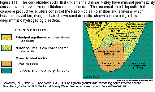
The Salinas Valley aquifer is contained within a structural trough
that is underlain and bounded on the margins by a complex of igneous
and metamorphic rocks of pre-Tertiary age. The crystalline rocks
in the trough are overlain by consolidated sedimentary rocks of
marine origin that yield only small volumes of water (fig.
119). The consolidated marine sedimentary rocks are in turn
overlain by semiconsolidated deposits of marine origin. Unconsolidated
continental deposits, which include the Paso Robles Formation
and constitute the principal aquifer, are the uppermost deposits
and fill the valley to depths of 1,000 feet or more.
Freshwater is contained mainly in the unconsolidated basin-fill deposits. In a few areas, sufficient water for domestic and stock use can be obtained from the semiconsolidated and consolidated rocks where they are fractured or weathered. The deeper unconsolidated deposits contain the largest amount of water in storage, but the shallower alluvial-fan and stream-valley deposits currently (1995) yield more water. Very permeable deposits of windblown sand are generally above the water table and, therefore, largely unsaturated; they do, however, form important recharge areas.
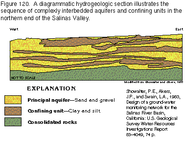
The Salinas Valley aquifer system is divisible into upper and lower ground-water basins. The upper basin extends from near the headwaters of the Salinas River and its tributaries to San Ardo, where the unconsolidated deposits narrow. The lower basin extends from San Ardo to Monterey Bay.
In the upper ground-water basin, the degree of confinement varies locally and depends on the presence and total thickness of deposits of fine-grained materials (fig. 120). Most ground water in deep deposits is confined, but the shallow ground water is, for the most part, unconfined. The thickest area of the aquifer in the upper basin is in the Estrella Valley where the unconsolidated deposits are as much as 1,750 feet thick. Recharge in the upper basin is from precipitation, infiltration from streams, and irrigation return flow. Ground-water discharge in the upper basin is by loss to streams, withdrawals by wells, and evapotranspiration. Nearly all the tributary flow to the Salinas River is in the upper basin.
Ground water in the lower basin is mostly under water-table conditions except on the northwest side of the valley from near Gonzales to Monterey Bay. In this area, a clay layer near the land surface provides varying degrees of confinement to water in the aquifers below. Infiltration from the Salinas River provides most of the recharge for aquifers in the lower basin. Nearly all the discharge in the lower basin is by withdrawals from wells.
Ground-Water Flow System
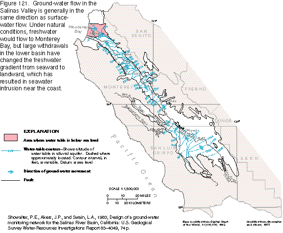
Ground-water movement in most of the valley is in the direction
of surface-water flow and follows the gradient of the land surface
seaward (fig. 121). In dry years, withdrawals
in the upper basin can disturb the natural ground-water flow patterns,
but normally the flow direction approximates predevelopment conditions.
In the lower basin, however, large withdrawals near Salinas have
diverted the natural seaward ground-water flow, and much of the
water now moves toward wells.
Much of the water that enters the upper basin from the surrounding mountains runs directly into the Salinas River and its tributary streams. The streams gain water by seepage from the aquifer system because the water table in the headwater area of the Salinas River is above the river level. From approximately San Miguel in the upper valley to Soledad, which is about 40 miles upriver from Monterey Bay, the water table in the vicinity of the river is approximately at the same altitude as the river level, so no water moves between the stream and the aquifer. At Soledad, the water-table altitude is lower than the river level, and the river loses water to the aquifer system.
Fresh Ground-Water Withdrawals
Water use in the valley has increased with a growth in agriculture
and population. During 1985, total ground-water withdrawals approximately
equaled the basinwide annual recharge of about 700,000 acre-feet.
Water levels in the upper basin have shown little decline because
of minimal ground-water development. Throughout the lower basin,
however, agricultural and municipal withdrawals caused a general
decline until the mid-1950's. In 1956, the flow of the Salinas
River became perennial with the regulation of the Nacimiento River.
Ground-water levels ceased to decline from San Ardo to Gonzalez
because the increased streamflow maintained recharge to the ground-water
system by seepage from the river. In 1967, a second dam was completed
on the San Antonio River and helped to maintain the year-round
flow of the river. Nonetheless, large and increasing withdrawals
near Monterey Bay downstream from the city of Salinas have resulted
in continued water-level declines, although availability of surface-water
recharge has increased. Water levels in wells in this area have
remained below sea level since the late 1940's and have resulted
in saltwater encroachment from Monterey Bay.
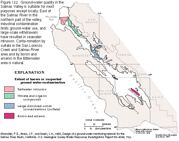
Ground-Water Quality
Ground-water quality in the upper basin is generally acceptable
for most uses, except in local areas. Dissolved-solids concentrations
in the water range from about 200 to 700 milligrams per liter.
The only major area of concern is the so-called Bitterwater area
in the upper basin (fig. 122), where
boron and arsenic that have been leached from aquifer materials
and consolidated rocks can be at excessive levels. Despite the
near absence of regional water-quality problems, agricultural
and industrial activities have resulted in localized aquifer contamination.
Dissolution of gypsum beds in the deep unconsolidated sediments and in consolidated marine deposits on the east side of the valley causes large concentrations of sulfate in ground and surface waters along the Salinas River and San Lorenzo Creek (fig. 122). Dissolved-solids concentrations in ground water in this area are as much as 3,000 milligrams per liter. Because the ground-water system receives recharge from surface water in the lower basin, ground-water quality in areas without gypsum beds can be affected by infiltration from streams that drain areas with such beds. Water in streams on the southwest side of the valley is less mineralized and partly dilutes the highly mineralized water during the wet season.
Aquifers near the coast are subject to seawater contamination when ground-water withdrawals in the area exceed natural recharge. Large withdrawals for agricultural and municipal supplies have lowered the potentiometric surface east of the city of Salinas until it is considerably below sea level (fig. 121). As a result, the natural freshwater gradient has been reversed from seaward to landward, which allows saltwater to enter the aquifer system where it crops out on the sea floor. Saltwater intrusion was already a concern when monitoring began in 1943, and, as of 1995, the area affected has increased greatly in size. The contamination has resulted in the abandonment of some wells.
Another area of concern in the lower basin is on the east side of the Salinas River between Soledad and Salinas (fig. 122). Organic pollutants and excessive nitrate concentrations that result from industrial and agricultural activity are possible threats to ground-water quality in this area.
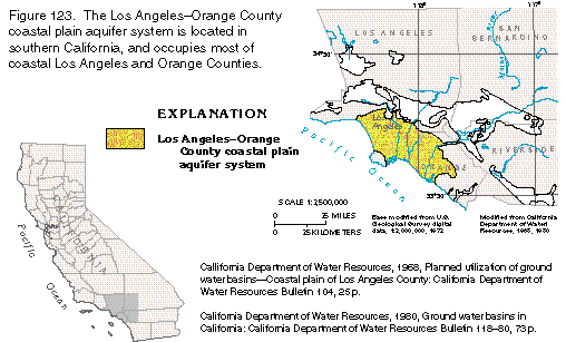
LOS ANGELESORANGE COUNTY COASTAL PLAIN AQUIFER SYSTEM
The Los AngelesOrange County coastal plain aquifer system
is located in southern California and is contained in a coastal
plain basin that extends over an area of approximately 860 square
miles (fig. 123). Ground-water development
began in the basin in the 1870's, when the demands of irrigated
agriculture began to exceed surface-water supplies; however, urbanization
subsequently displaced most of the agriculture in the basin, and
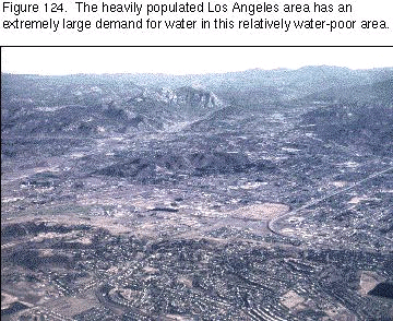
today the predominant use of water is for public supply. Because
metropolitan Los Angeles and the surrounding area is one of the
largest population centers in the world (fig.
124), the demand for water is great. In addition to local
ground-water sources, water is imported from the Colorado River,
the Owens Valley, and northern California by an aqueduct system.
Also, reclaimed wastewater is spread in recharge areas for ground-water
replenishment and is pumped into the aquifer system near the coast
to prevent seawater intrusion.
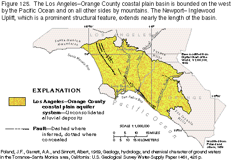
The Los AngelesOrange County coastal plain basin is bounded on the north and east by the Santa Monica Mountains and the Puente Hills, on the south by the San Joaquin Hills, and on the west by the Pacific Ocean (fig. 125). The mountains are underlain by consolidated rocks of igneous, metamorphic, and marine-sedimentary origin. These consolidated rocks surround and underlie thick unconsolidated alluvial deposits. The major drainages in the basin are the Los Angeles, the San Gabriel, and the Santa Ana Rivers, all of which have headwaters outside the basin.
Marine sediments deposited during periodic encroachment of the sea and alluvium derived from weathering and erosion of the rocks in the surrounding mountains have filled the basin with a thick sequence of deposits. The surface of the basin is relatively flat, but upwarping along the NewportInglewood Uplift (fig. 125) has formed hills that rise in places as much as 400 feet above the surrounding coastal plain. Also, along the coast from just north of Long Beach southward to the San Joaquin Mountains, resistant sediments of late Pleistocene age underlie several mesas. The mesas are separated by erosional gaps through which the major drainages either now flow or have flowed historically.
Climate in the basin is Mediterranean, characterized by warm summers, cool winters, and markedly seasonal rainfall. Nearly all rain falls from late autumn to early spring; virtually no precipitation falls during the summer. The average annual rainfall in Los Angeles is about 15 inches. Potential evapotranspiration in the coastal plain exceeds precipitation on an annual basis, and, under natural conditions, the lower reaches of rivers that drain the basin are dry in summer.
Aquifers and Confining Units
The Los AngelesOrange County coastal plain basin is a structural
basin formed by folding of the consolidated sedimentary, igneous,
and metamorphic rocks that underlie the basin at great depths.
Although the subsurface structure of the basin is complex, two
major northwest-trending troughs (fig.
126), which are separated for most of their length by an uplifted
and faulted structural zone, contain the sediments that compose
the aquifer system. These sediments are as thick as 30,000 feet
in some areas.
The coastal plain aquifer system is made up of as many as 11 locally named aquifers. Each consists of a distinct layer of water-yielding sand and gravel usually separated from other sand and gravel beds by clay and silt confining units (fig. 126). In many places, however, either the water-yielding sediments are in direct hydraulic contact or the intervening confining units contain sufficient sand and gravel to allow water to pass between adjacent aquifers.
A layer of clay and silty clay of marine and continental origin, which is at or near the land surface over most of the basin, is a competent confining unit where it does not contain large amounts of sand and gravel. This confining unit ranges from less than 1 foot to about 180 feet in thickness. Near Santa Monica and San Pedro Bays, the confining unit is not present, and ground water is under unconfined, or water-table, conditions.
Freshwater is contained within deposits that range in age from Holocene to late Pliocene. The main freshwater body extends from depths of less than 100 to about 4,000 feet. At greater depths, the water is saline and unpotable. The freshwater body is thickest near the axis of the troughs where water-yielding sediments reach their greatest thickness and thinnest where these sediments overlie anticlines or become thin at the margins of the aquifer system.
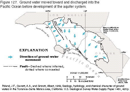
Ground-Water Flow System
Before development, ground water in the basin flowed generally
toward the Pacific Ocean (fig. 127).
Natural recharge, which is virtually all from precipitation, entered
the aquifer system at the basin margins as runoff from the mountains,
losses along stream channels, subsurface flow from adjacent basins
to the north, and precipitation that fell directly on the basin
floor. Where aquifers are hydraulically connected and sufficient
differences in hydraulic head existed, some water doubtless flowed
from one aquifer to another.
Structural features, such as faults and anticlines, alter or restrict ground-water flow at several places in the Los AngelesOrange County coastal plain basin. The most prominent structural zone is the NewportInglewood Uplift (figs. 125 and 126), which trends northwestward, extends virtually the entire length of the basin, and is approximately perpendicular to the direction of natural ground-water flow. The aquifers might be interrupted by faults or thinned near the upwarped structural zone, but, for the most part, such restrictions are not complete barriers to ground-water flow. The sediments that form the mesas along much of the coast have minimal permeability and also impede ground-water flow; however, erosion formed gaps in the mesas, which subsequently filled with alluvial deposits; these gaps allow water to move between the inland aquifers and the sea.
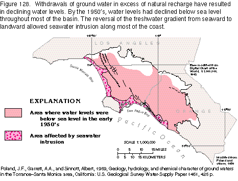
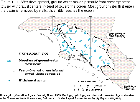
Ground-water flow directions have been altered by withdrawals in the basin. Rapid urban development and the accompanying increase in withdrawals resulted in severe declines in water levels that began in the early 1900's. As a consequence, ground-water gradients near the coast reversed from seaward to landward in some areas in the 1920's, and saltwater intrusion was detected in 1932. Virtually the entire coastline was affected by the 1950's (fig. 128). The hydraulic gradient is now (1995) primarily from recharge areas toward withdrawal centers, rather than toward the ocean (fig. 129). Withdrawals in the deeper aquifers also have created a downward hydraulic gradient over much of the basin. Large expanses of the basin surface have been urbanized, thus decreasing the potential for direct recharge to the aquifer system and increasing the potential for saltwater intrusion.
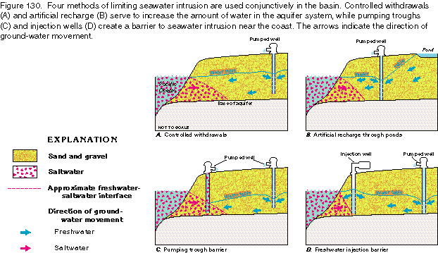
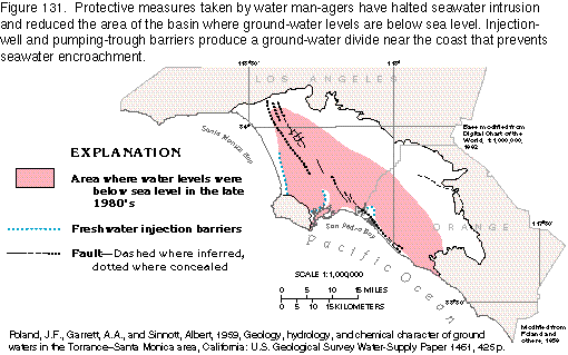
The critical need for a solution to the seawater encroachment problem brought about coordinated management of water use in the basin beginning in the 1950's. Several methods have been employed to stop the steady progression of seawater into the basin (fig. 130). Ground water, which accounted for 40 to 50 percent of the water used in the basin, was augmented by large amounts of surface water imported from the Colorado River, the Owens Valley, and northern California. In some areas, particularly near the coast, withdrawals have been reduced or wells abandoned (fig. 130A). This has, to some extent, lessened the landward gradient. Artificial recharge (fig. 130B) through ponds or by water spreading, using imported water or reclaimed wastewater, replaces some of the ground water lost from storage and partly compensates for the loss of recharge potential that results from urbanization. Three barriers have been constructed near the coast in areas where seawater was encroaching into the freshwater aquifer system. The barriers consist of a series of either pumping wells that will remove saltwater from the aquifer and form a trough barrier (fig. 130C) or injection wells that pump reclaimed waste water into the permeable sediments, and thus establish a narrow zone in which the freshwater gradient is seaward (fig. 130D). In some places, wells that withdraw saline water from the aquifer system on the seaward side of the injection wells are part of the barrier. To date (1995), the combination of methods has been successful in halting seawater intrusion and also reducing the area of the basin with ground-water levels below sea level (fig. 131).
Ground-Water Quality
The quality of water in the confined aquifers in the basin is
generally suitable for most uses. Dissolved-solids concentrations
in the water are generally less than 500 milligrams per liter
and concentrations of chloride do not exceed drinking-water standards
recommended by the U.S. Environmental Protection Agency. Water
imported from the Owens Valley and the Colorado River for recharge
has larger concentrations of dissolved solids, chloride, and sulfate
than the ground water, but the quality of the mixed native ground
water and imported water is within State and Federal standards
for drinking water.