GROUND WATER ATLAS of the UNITED STATES
California, Nevada
HA 730-B
Basin and Range aquifers
There are two different files for each illustration
- A 72 ppi GIF file, suitable for screen viewing is accessed through
the thumbnail image
- An eps file, suitable for downloading to be printed or edited is accessed
through the "eps file" link. Most files are Adobe Illustrator
5.5, exceptions are noted. These files have been compressed with GNU's gzip
utility. If your web browser defaults to a screen display of the file, turn
on the "Load to local disk" option before downloading. Download
and process these eps files as ascii, not binary.
Ground-water flow systems - -Partly drained, closed basin
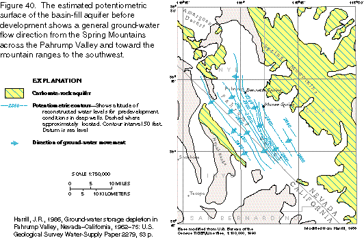
Figure 40 Map of potentiometric surface, Pahrump Valley (21K)
 editable eps
file b040.eps (77K compressed)
editable eps
file b040.eps (77K compressed)
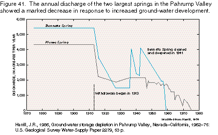
Figure 41 Map of potentiometric surface,
Pahrump Valley (9K)
 editable
eps
file b041.eps (11K compressed)
editable
eps
file b041.eps (11K compressed)
Figure 42 Graph of ground-water withdrawals, Pahrump Valley (9K)
 editable eps
file b042.eps (11K compressed)
editable eps
file b042.eps (11K compressed)
Figure 43 Map of water-level decline, Pahrump Valley (22K)
 editable
eps
file b043.eps (78K compressed)
editable
eps
file b043.eps (78K compressed)
Figure 44 Graph of water level, Pahrump Valley (10K)
 editable eps file b044.eps
(16K compressed)
editable eps file b044.eps
(16K compressed)
Figure 45 Map of ground-water withdrawals, Pahrump Valley (19K)
 editable eps
file b045.eps (92K compressed)
editable eps
file b045.eps (92K compressed)
 editable
eps
file b041.eps (11K compressed)
editable
eps
file b041.eps (11K compressed) 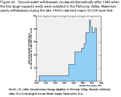 editable eps
file b042.eps (11K compressed)
editable eps
file b042.eps (11K compressed) 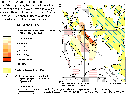 editable
eps
file b043.eps (78K compressed)
editable
eps
file b043.eps (78K compressed) 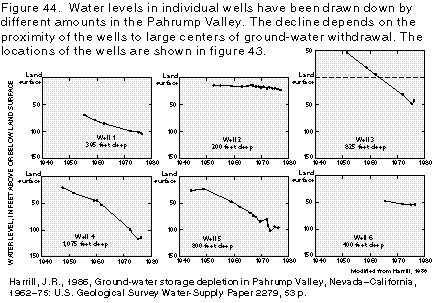 editable eps file b044.eps
(16K compressed)
editable eps file b044.eps
(16K compressed) 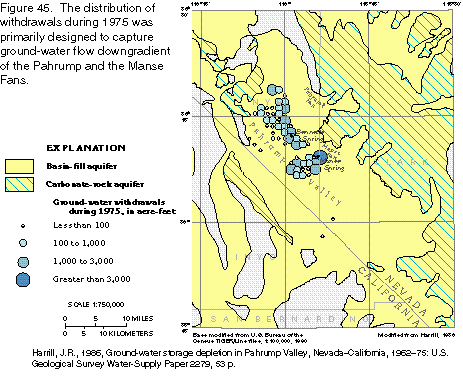 editable eps
file b045.eps (92K compressed)
editable eps
file b045.eps (92K compressed)