GROUND WATER ATLAS of the UNITED STATES
California, Nevada
HA 730-B
Basin and Range aquifers
There are two different files for each illustration
- A 72 ppi GIF file, suitable for screen viewing is accessed through
the thumbnail image
- An eps file, suitable for downloading to be printed or edited is accessed
through the "eps file" link. Most files are Adobe Illustrator
5.5, exceptions are noted. These files have been compressed with GNU's gzip
utility. If your web browser defaults to a screen display of the file, turn
on the "Load to local disk" option before downloading. Download
and process these eps files as ascii, not binary.
Ground-water flow systems - -Terminal sink basin
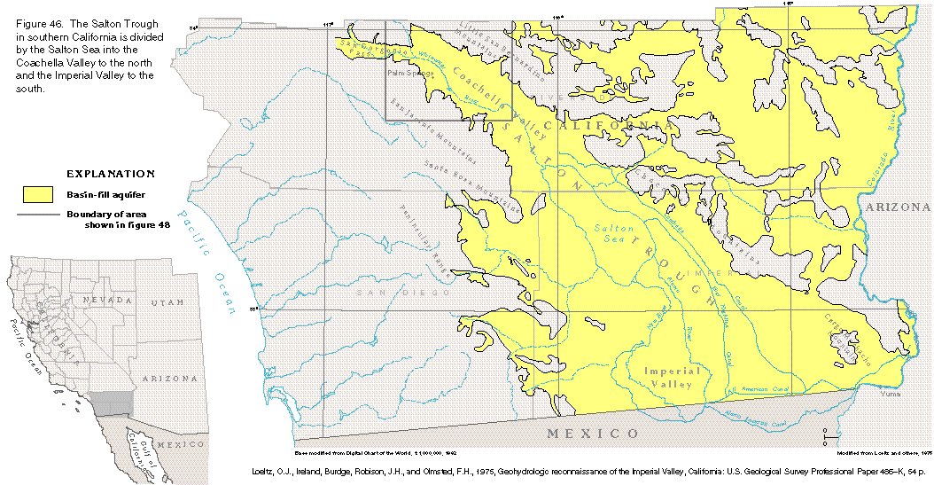
Figure 46 Map of Salton Trough, California (55K)
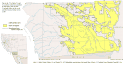 editable eps
file b046.eps (214K compressed)
editable eps
file b046.eps (214K compressed)
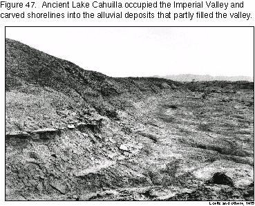
Figure 47 Photograph of shorelines
of ancient lake Cahuilla (101K)
 This illustration contains
a placed image. Download the Adobe Illustrator 6 eps
file b047.eps (1.3M compressed) which contains an imbedded Adobe Photoshop
3 (eps) file. You may also want to download the editable
Photoshop file b47psh.eps.gz(1.3M compressed)
This illustration contains
a placed image. Download the Adobe Illustrator 6 eps
file b047.eps (1.3M compressed) which contains an imbedded Adobe Photoshop
3 (eps) file. You may also want to download the editable
Photoshop file b47psh.eps.gz(1.3M compressed)
Figure 48 Map of upper Coachella Valley, California (15K)
 editable eps
file b048.eps (47K compressed)
editable eps
file b048.eps (47K compressed)
Figure 49 Map of geology, Salton Trough (41K)
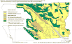 editable
eps
file b049.eps (234K compressed)
editable
eps
file b049.eps (234K compressed)
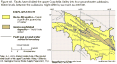
Figure 50 Map of water-level rise, Imperial Valley, California (18K)
 editable eps
file b050.eps (45K compressed)
editable eps
file b050.eps (45K compressed)
Figure 51 Graph of annual water-level loss, Imperial Valley (10K)
 editable eps
file b051.eps (12K compressed)
editable eps
file b051.eps (12K compressed)
Figure 52 Map of potentiometric surface, Salton Trough (42K)
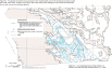 editable eps
file b052.eps (161K compressed)
editable eps
file b052.eps (161K compressed)
 This illustration contains
a placed image. Download the Adobe Illustrator 6 eps
file b047.eps (1.3M compressed) which contains an imbedded Adobe Photoshop
3 (eps) file. You may also want to download the editable
Photoshop file b47psh.eps.gz(1.3M compressed)
This illustration contains
a placed image. Download the Adobe Illustrator 6 eps
file b047.eps (1.3M compressed) which contains an imbedded Adobe Photoshop
3 (eps) file. You may also want to download the editable
Photoshop file b47psh.eps.gz(1.3M compressed)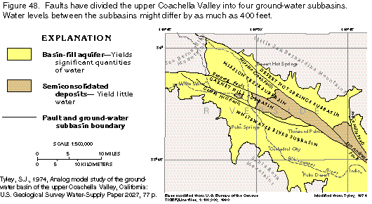 editable eps
file b048.eps (47K compressed)
editable eps
file b048.eps (47K compressed) 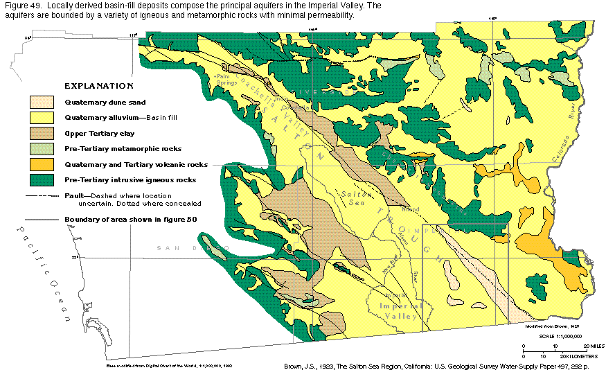 editable
eps
file b049.eps (234K compressed)
editable
eps
file b049.eps (234K compressed) 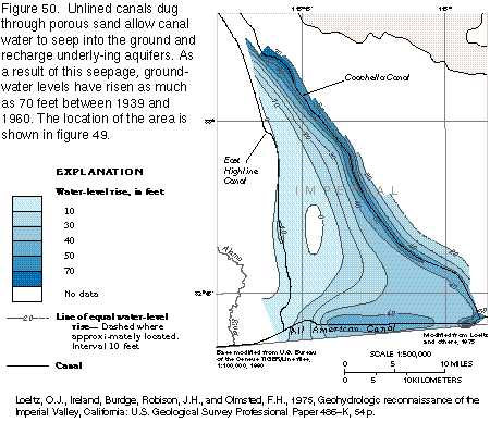 editable eps
file b050.eps (45K compressed)
editable eps
file b050.eps (45K compressed) 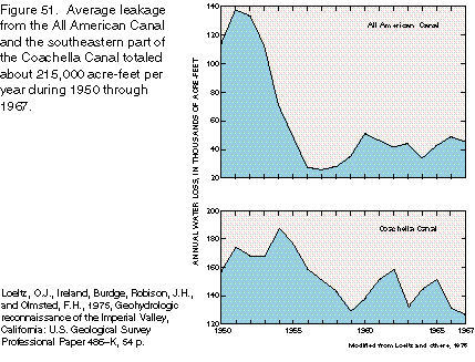 editable eps
file b051.eps (12K compressed)
editable eps
file b051.eps (12K compressed) 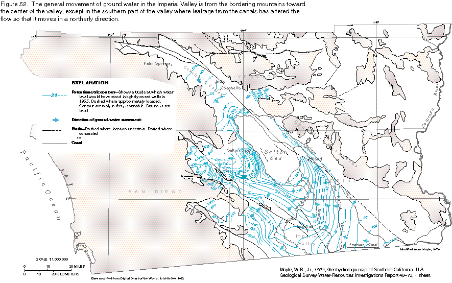 editable eps
file b052.eps (161K compressed)
editable eps
file b052.eps (161K compressed)